Monday, July 27, 2020

Back on the maintenance road: stock pond is still dry


I was curious to see the stock pond that I normally take the dogs on.  Was there water in it?  What about any wild flowers?  It has been over a month since I last walked the dogs here and I wanted to see any changes.

I took the four old dogs on a morning sunrise walk at 5:20am  All four were excited to finally get out of the yard again and did well.  Sadie's hind legs gave out briefly at the start, but she quickly recovered.  Minnie was slower than the rest but not a hindrance.  I wanted to make sure this was a walk and not a speed race.

Clouds were overhead when the sun rose at 5:34am for a brief outburst of color.  There was no water in the stockpond, and Minnie's disappointment was obvious.  She looked down into the empty pit and didn't rush into it like the other three, who were happy to chomp on some grass.  There weren't any wildflowers, either.

We did a mere 1.15 miles.  I turned around and then focused on the backyard once back home. Other than some catnip, there was nothing else salvageable from my container garden.  There was nothing left of the potted strawberries. Plants that were still in pots had died from lack of water.  It was all sad to look at, after all the attention I gave the plants, especially the strawberries that were busy reproducing, earlier this year.

Clouds were forming overhead and it looked like rain.  Susan later said she was hit hard coming back from Tombstone, but nothing fell over us.  We agreed to meet at 5:30pm for a quick walk up Miller Creek.  There was one car in the parking lot and no one else on the trail.  The clouds cleared during our mile-long walk.

We both found an Eyed Click Beetle along the path.  The black-white coloring of the beetle against the dead leaves stood out along the trail and caught our attention. This two-inch-long beetle has two fake eyes that make it look spooky, but it's actually a beneficial beetle to have while in the larvae stage.  When placed on its back, the beetle can jump up and bend itself back on its legs and move on. My Google phone was dead, so Susan took the posted photo of the beetle.

Sadie now collapsed four more times during this slow walk.  Watching her was like watching someone trip over a tree root; nothing serious. She didn't always fall completely. She always got back up without a whimper. Susan thinks it's because of lack of exercise in the past month, but I fear she has developed canine degenerative myelopathy, where the back legs slowly weaken to the point where total paralysis sets in.  This is what Sammy had in the last three months of his life, 2016-2017, which got problematic because of his arthritis n that last month of his life when I'd help him get up on his feet.  There is no cure nor treatment for this physical disability.  His last week alive was very painful for him.

I love Sadie so much.  She took me through the rough years post-military.  Her condition is in its early stage; she can still get up on her own and enjoy life and enjoy her walks.  She does spend most of her time now napping on the patio, but at 12+ years she has deserved that privilege. I dread the day she will have to be gently euthanized.  A dog as loyal as she does not deserve to suffer.

***
Global cases: 16,563,556
Global deaths: 656,587
US cases: 4,399.135
US deaths: 150,100
AZ cases: 162,014
AZ deaths: 3305
IN cases: 62,907
IN deaths: 2906

Sunday, July 26, 2020

Pine Park trail in the Chiricahuas, southeastern Arizona

Distance: 7.4 miles (this includes exploring the creek around the campsite)
Elevation: 5852' -7959'
Significance: Creek water at the start, scenic views at the peak

I woke up with the sun, which under deep canopy was more like 6:11am.  It had been a quiet night with a pleasant wake-up temperature of 62F.. No one ever came to join me in the John Hands campground where I had parked for the night.  I drove up to the Herb Martyr campground a mile up the road (which now charges $15/night), parked the Honda and walked down to the creek to look for any trails starting there at 6:34am.  The last time I was here was when Kevin and I camped out with Eric, and Sara and Sammy got skunked.  That had to have been in 2011.  All I remember was the rushing creek and access to several trails.  Where were the trail heads now?

The most recent forest fire of 2011 has made the creekbed more rocky and part of the trail washed out, but this is still a pleasant trail that is easy to follow. The creek was rushing well.   I passed three campers as I began this adventure.  I walked around for almost a mile around the campsite, found the Herb Martyr Little Dam and walked along the creek for Zeke's benefit, before finding the trail that took me up to Pine Park.  It was my first time up this trail and it worked well in the end.  The official trail is only three miles one way and I made this a 7.4-mile hike,  Most of the extra mileage was along the creek.

I started this hike at 7:11am under the cool shade of early morning.  The aroma of wet pine needles was refreshing. The trail starts at the Herb Martyr campground as the Basin Trail and follows the creek for a half mile before climbing up a steady incline through new growth of scrub oak.The second mile is higher up and more exposed, with new growth oaks not more then ten feet tall.  I still had morning shade going up, but coming back down with the sun higher up, this section was a bit warm. I'm glad I started this hike early, as doing this at high noon would have been far less pleasant.

I hiked at a steady pace.  The grade is rated as moderate but I had no trouble.  I stopped once for Zeke to give him some water.  I could see Pine Park all throughout this hike, but the closer I got to my destination, the narrower the trail became.  Trees that had been burned in that last fire are less noticeable now with the ample new growth of pines and oaks and, near the park, of fern still wet with morning dew.

I enjoyed that last mile.  While the trail got narrower, it also opened up to great views of the various peaks in the Chiricahuas.  I passed a spring near the peak, took a break 1/4 mile from the peak when I got a phone call from Carol.  She had been released from the hospital on Friday and is back to using 24-hour home care.  She sounded in good spirits.  I hope now she follows doctor's orders and takes her electrolyte supplements.  It was a relief to hear her chirpy voice.  I just hope she means what she says about following doctor's orders.

The seven-minute call gave Zeke a break in the shade.  We didn't have much farther to go to reach Pine Park.  Many old trees survived the fire and are still alive and standing tall, but the new growth is going to be dominated by oak.  Ferns cover the lower ground.  The park is a nice area to set up camp if one is continuing on via the Snowshed trail. Before the fire this must have been a shady area to rest for the day. This could be another hike I could do from another trailhead on the western side of the mountain range for another time.  The views alone are worth it.

We went back the way we came.  There was still enough shaded parts to make this a very enjoyable hike.  It took us 3:40 hours.  Campers were breaking down their campsites as I got back to my Honda.  It was 10:10am and I was looking forward to getting home to Kevin and the dogs.  This hike was a great way to end my road trip, with good news about Carol and good weather with low humidity for the final hours.  Clouds were billowing over the Chiricahuas but it never rained until early in the evening, when thunder rumbled over the Huachucas.

I got home at 12:24pm.  The dogs were happy to see me.  The pups were at first unsure, but then rememered who I was and jumped up on me. I then saw what Kevin was referring to about the pups' damage: my entire potted strawberries and herb garden was dug up.  Nothing remained of all the new growth this year.  Nothing.  And there were cans and other kinds of trash strewn all throughout the back yard.  I cried quietly.  The same few dishes that were in the sink when I left a month ago were still in the sink, with a few more dirty dishes added. Couldn't Kevin have at least washed all those dishes?  Bad back, replied Kevin.  I have a bad, chronically pained back, too, but standing and walking are fine with me.  It's the constant bending over that pains me.

Despite this, I was glad to be back home and off the road for a while.

***
Global cases: 16,432,937
Global deaths: 654, 018
US cases: 4,371,451
US deaths: 149,845
AZ cases: 162,014 (1388 in Cochise County) 
AZ deaths: 3,305 (43 in Cochise County)
IN cases: 62,372 (6716 in Lake County)
IN deaths: 2,903 (281 in Lake County)

Saturday, July 25, 2020

Truth or Consequence's Healing Waters trail and a few other shorter trails in the Gila Mtns


I slept good.  I had stopped at a truck stop in Lemitar, NM with a direct view of the sun rise.  The sky was still very cloudy and it remained so all morning, allowing me a cool walk in Truth or Consequences (Palomas Hot Springs) off I-25.  ToC is a small town of just 6000.  I like passing through this town on road trips because it has all the amenities, but this morning the Black Cat Coffee shop was closed and the microphone at the McDonald's drive-thru wasn't working well so I drove off from the drive-thru with no coffee to start my day.  Drinking Diet Pepsi gives me some caffeine, but it's just not the same.

I googled the town for any parks along the Rio Grande and found Rotary Park, a primitive green space to launch rafts from.   I figured I'd do whatever trail there was, no matter how short.  I was in luck.  A sign prominently posted in the parking area showcased the "Healing Waters Trail" but there was no mention of its length.

I decided to explore this part, crossing a metal bridge over a pond before continuing uphill. The trail never gets to the river, just near it. I needed to walk a bit to loosen my body after sitting in the Honda for so long.

People were already fishing from the banks as I walked past.  Rafters were getting their gear ready for the river, which was following nicely. The storm from last night had washed more debris across the trail. It's not a developed area, but it's a good place to start the Healing Waters trail, among the smells of the desert and the sounds of rushing water.  This trail is not listed in Alltrails.com, perhaps because it is an urban trail for most of its route. 

I climbed up a small hill, walking up still very damp sand.  The hill felt brittle, as if it would collapse into the river at any time.  The trail is lined with large rocks and railroad ties, many which have rolled downhill.  The trail here could use some maintenance but it's mostly easy to follow.


Metal stairs took me up a steep section which Zeke refused to take. The Carrie Tingley Veterans Hospital is at the top of this hill.  Tingley established this clinic initially for "crippled children."  It's now a Veteran's Hospital.


I stopped to read all the historical markers along the way.  The town became popular through its hot springs 100 years ago, but seems to have fallen on hard times more recently. An older woman in a plaid blue shirt passed me by quickly. I never could catch up to her as she walked with a purpose.  We didn't exchange any greetings.

I topped out at the hill by the Veteran Memorial before continuing on South Broadway's sidewalk going into the historic district.  The natural trail now gave way to city pavement and loud traffic.  While I love history of all kinds, the calming, natural part of the trail was now over.

I enjoyed the river area, but walking on that sidewalk so close to traffic was not my cup of tea and I cut this walk short. I don't mind urban trails, but this one was too loud for Zeke and I didn't enjoy trucks roaring so close to us. 

I took a residential street back to where I parked, passing by some yards that looked like they came out of Bisbee.  Dips in the streets were filled with water, which ravens were using as their bathwater. We had walked 2.6 miles and the sky was still cloudy, with darker clouds east of the Rio Grande. A local man was out holding anti-Trump signs across from the dog park.  I stopped at the dog park but Zeke showed no interest in other dogs.  It was time to move on.

I continued on via S I-10, then took NM152 into Hillsboro, over the Black Range and into Silver City.  This area took a brutal hit during a 2005 wildfire.  Treeless hillsides are still visible. This is a scenic drive but definitely no short cut, as some of the curves require one's full attention.  Clouds were looking stormy when I reached the 8228' Emory Pass.  I've always wanted to spend some time in this mountain range, as there are many trailheads accessible right off NM152.

I stopped at the Lower Gallinas trailhead and walked the creek dowhill for  1.2 miles. constantly in the cool shade.  It was a different story once I made it into town, when that cool 67F became 83F.

Silver City is taking covid seriously.  People were wearing face masks while walking down the street. Even the Toad Creek Brewery has limited hours.  My dinner was a mediocre combo meal at Del Taco and then I decided to try the Dragonfly trail on the east side of town.  I did this two years ago with Sadie and never did see any petroglyphs.  Today I walked the trail counter-clockwise and still didn't see any.  The creekbed was dry, too, despite last night's rain.  This is a pretty trail with minimal elevation gain that one can take into the wilderness to other trails higher up.  Alltrails says it's 3.2 miles but again I got more than 4 miles.  My GPS read 6.9 miles with all the exploring I did again.

I wanted to hunker down in Silver City for the night and then opted to leave and camp in the Chiricahuas for the night, with a possible last hike there before heading home.  I left the area at dusk, wishing now I had left earlier to catch the sunset over the Chiricahuas.  I must make Silver City a long weekend destination, as there are so many trails I still need explortng in the Black Range

Friday, July 24, 2020

Foss State Park, OK


I left the rest area before sunrise.  I wanted to get to Tinker AFB and use the gym to shower.  But I somehow got through the wrong part of the base where there was no gym.  I didn't want to waste time finding a gym and left, only to land a few hours later at Foss State Park just west of Oklahoma City.  This was a nice three-hour break from driving.  I realize now I don't give Oklahoma enough credit for prettiness.

The park is 12 miles north of I-40 on Foss Reservoir.  Day use is $10 and the park office has a credit card machine outside. I paid the fee, then drove down to the tent site area where I washed up.  There was a truck parked nearby, but didn't see any tent so perhaps the people were sleeping in the large truck.  I felt alone enough to wash my hair, let Zeke wade in the clear water, and explore the park.

The park is a haven for water sports.  It has a marina on the south side of Foss Lake, and a beach on the north side.  No dogs are allowed on the swimming beaches.  The tent campground was at a part of the south lake with no beach.  The red sand bluffs on the shore were at least six feet tall and littered with snags. Alltrails.com mentioned The Great Western Trasouil running through the park and I wanted to hike on it for a few miles.  It was 9:30am and the weather was partly overcast and low 70s.

The park has a short "Heart Healthy" trail that connects the Cottonwood campground with the Cedar Point campground, but I was looking for something more along the lakefront.  I found an unmarked road off the Cottonwood campground and walked on that.  That was a pleasant 0.7 miles to a boat launching site, more red bluffs and snags, and dead trees in the water.  This must not be a popular site!  A more grassy trail came in from the west and I continued on that trail.  This was mostly a prairie trail, with star thistle and lots of blue-bellied dragonflies.  My GPS showed me walking in a loop, but no official trails showed up on the map.

The grassy trail became more overgrown the longer I was on it.  At one point I came across an abandoned picnic table erected in August 2017 by Eagle Troop 355, with a sign stating that hunting was not allowed past this sign.  So was I walking on a hunting trail up to this point?  There were definitely deer around watching us. I turned on the trail leading from the picnic table, but now the grass was even more overgrown.  It was not conducive to hiking so I went back on the loop to complete 2.6 miles.

I drove around the park to explore more.  OK64 travels north over Foss dam.  Here is where the beaches are. There were no waves on the south shore, but they were certainly rolling in on the north shore beach, where most of the visitors were.  I stayed away from the beach as dogs are not allowed in the swimming areas.  The park continues on the north shore with more campgrounds, but I was now ready to move on.  I will visit Red Rock Canyon on my next drive through Oklahoma.

I stopped in Elk City at a Braum's and had a simple poppyseed-chicken salad that also had blueberries and strawberries thrown in.  Braum's is all over the central Midwest and serves good ice cream and burgers and also has its own line of groceries in each store.

The sky was getting dark as I drove west on I-40.  I didn't veer off Route 66 this time; I stayed on the interstate to make good time.  My next planned stop was Amarillo.  I wanted to stop at the Six Car brewpub in the downtown area, discovering along the way that my favorite Mexican restaurant, Acapulco, has closed!  The interior was completely gutted and two homeless men were sleeping out front.  What had happened for this established business to close?  All I could find out is that in late January there was an eviction notice on the front door, so they have been closed at least six months.  Many Yelp reviews stated the restaurant had a bad smell and that often the music was too loud.  Well, those two things will certainly keep me away.  The owner, Robertino Alberran, also has a criminal record with three DUIs and one for public intoxication going back to late 2010-June 2016 but I haven't found any recent health code violations.

My stay at the SixCar brewpub was as long as it took me to have two beers.  I didn't go inside as masks were required and I had left my mask in the car.  Touchless menus were available scanning barcodes via cellphone cameras, and beer was served in plastic cups.  This wasn't quite the atmosphere from my last visit, where kids played out in the patio and the tables were crowded, but it's a nice brewpub with a kid and dog-friendly ambiance.

Storm clouds continued to grow as I continued west.  I stopped at the one Texas rest area on I-40, walked around wild sunflowers (only to get stung painfully by a fire ant!).  I see more sunflowers in Texas than in Kansas.  It's a nice rest area, with a museum inside talking about the panhandle history and its wind, free wifi, and a tornado shelter on either side of the building.  The first of several storms exploded over me when I was inside using the bathroom..and I had left the rear windows open for Zeke .

I stopped in Cline's Corner in New Mexico where another storm exploded.  A few hours later I settled at a rest area on the south side of Albuquerque.


***
C/76 Acapulco Mexican Restaurant 727 S. Polk St. Several items uncovered during storage; employees did not wash hands when changing gloves or changing tasks; ice machines need to be cleaned; sanitizer in bucket in salsa bar at improper strength; dirty dishes on prep line with clean dishes; placecard was removed (placecard must not be defaced or removed, resulting in a re-inspection fee charged. Additional action or fines may be applied for tampering or removing the sign again). COS. Clean dishes must be completely separated from dirty dishes at all times. To be corrected within three days. Faucet in women’s restroom not working properly; English hand washing sign needed in men’s restroom; no soap in men’s restroom; thermometers needed in all coolers holding potentially hazardous foods; accessible hand sink must be available in all food prep areas; items in hand sink; hand sink in ware washing area blocked by dishes. To be corrected within 10 days. No certified food manager; inside coolers/freezers need to be defrosted and/or cleaned; under sinks/equipment in bar needs to be cleaned; grease build-up needs to be removed; floors, walls and ceilings need to be kept clean at all times; several cutting boards need to be resurfaced or replaced; date marking labels found on clean dishes; prep sink with an indirect waste connection needs to be installed. To be corrected within 30 days. 3/11/2018 

Thursday, July 23, 2020

Giant City State Park, southern Illinois

Distance:  three short trails totalling 2.8 miles
Elevation
Significance: shaded trails in and around interesting rock formations

I woke up to dense fog that diffused the sunrise.  I had climbed up the park's water tower - observation deck to see the canopies, but I got very little to see in the mist.  As soon as the official sunrise was over at 6:18am, I drove off to the first trail, the 1.3-mile long Trillium Trail north of the lodge and near the group campground. 

Fog was still dampening any light, but I could see the trail clearly.  Bright orange chanterelle mushrooms dotted the path as I maneuvered around interesting sandstone rock formations, some with dripping water, and a trickling brook.   The smells alone were worth this trail, as a  around me I saw cool greens and browns.

I was done in 40 minutes, then drove off to the next trail, the Indian Creek Nature Trail.  Access to this trail is also off the Giant Creek Road. This one-mile loop was even more interesting, with more of an elevation, stairs, and even more grandiose geology.

Deep, narrow paths were formed here from powerful water, creating "streets" in the rock.  It was like walking through a medieval village with its narrow paths. Lush green moss grew on the rock walls.  Wet flora scented the area as I explored in and around the rock.  Part of this trail also consisted of stairs to get over the wet rock.  I found this trail the most scenic of the three that I explored.


The third and last trail was the much shorter Devil's Standtable trail. The trailhead is right off the Giant City Lodge road.  It's listed as 0.3 miles but I clocked in 0.54 miles, exploring the rocks in greater detail.  The actual standtable resembles more a devil's penis, but I will say no more.

Old graffiti from the late 19th century were still evident in the sandstone below the standtable.


I never met anyone on any of these trails, but by now power walkers were on the road greeting me.  I left the park at 8am as the rest of the park was just waking up.

I visited this park because SteveT recommended it.  I'm glad I went out of my way to see this.   I never saw any trash along the trails.  This park is harder to reach than Starved Rock State Park and the smaller crowds make this park more enjoyable. I hope to be back on my next summer road trip as I left so much unexplored, both in Carbondale and in the park.

Getting back on my route was more difficult, though.  It was all backroads for several hours, through the Shawnee National Forest.  I toured parts of the Southern Lincoln Heritage trail, including a stop in the small town of Jonesboro, where Abrahm Lincoln and Senator Stephen Douglas held their third debate on September 15, 1858 (Douglas won and retained his Senate term).  A half-mile path around a pond complimented my stay at the Lincoln Memorial park, along with standing next to a life-size statue of Lincoln.  He was over 6' tall, while Douglas in comparison didn't seem taller than 5'6".

I took IL127 back toward I-57, but then missed the turn-off to Cairo, a river town straddling both the Mississippi and Ohio Rivers.  It was once a busy town in the days of Mark Twain and I've toured the city at least twice.  I wanted to see if businesses have come back, as the town was dead the last two times I was there.  Alas, I didn't have a quick way to get into Cairo, and just resumed my drive into Missouri and then Arkansas.

This last stretch was not very scenic at all.  I was driving through the flat Mississippi River Valley where the best crop to grow is cotton. Towns in both Missouri and Arkansas looked abandoned. Storm clouds intermittently interrupted the boredom I felt on this stretch.

I drove through Popular Bluff, MO via US60.  That was a disappointment except for its interesting old theatre and its marquee.  I should have stayed on I-57 until reaching I-40 as I lost a lot of time in these pokey little towns.  Most everything was closed, too, thanks to covid fears.

I made it to Fort Smith, AR and the Bricktown Brewery at 7:40pm, with 20 minutes before closing.  Its large patio is dog friendly.  I like this chain brewpub and I like their spicy chicken sandwich with spicy cole slaw.  I had that with a blueberry ale before resuming my drive.  Unlike my last two visits to Fort Smith, I did not walk the grounds of the historic fort along the Arkansas river.  My goal now was to get across Oklahoma as fast as possible.  Driving through Oklahoma at night at least was more tolerable rather than the high humidity and scenic-less driving I endured driving through the state a month ago.  I pushed myself to stay awake, making it to just outside Oklahoma City and a very busy rest area.

Wednesday, July 22, 2020

Kankakee River State Park, IL

Distance: 2.2 miles of a 10.5-mile paved multi-use trail along a shaded river bank
Elevation
Significance: cool, shaded paved path under a thick camopy of trees native to Illinois
https://www2.illinois.gov/dnr/Parks/Activity/Pages/KankakeeRiver.aspx

What a busy morning!  It all took off as soon as I got up at 6:37am to let Zeke out to pee.  I packed garden supplies from Carol's garage that she allowed me to take with me, washed the bed sheets, took more phone calls from Adrene (who still doesn't know that Carol doesn't want her working for her anymore because of her attitude), and met Hank when she stopped by at noon.  I had planned on being on the road by 9am, so obviously I was still on schedule. I always seem to leave for road trips at N hour + 3.

Hank is Carol's cousin with whom she's close.  They grew up together.  Hank told me that even as teenagers, Carol was bossy and at times gruff with her.  Hank is now in charge of all of Carol's household chores like paying bills and balancing the checkbook, buying groceries, etc.  Lately Carol has been disrespectful toward her, according to Hank, and Hank is losing patience with her.  Yet she still comes over to help Carol out.  For how much longer, though?  Hank is now 70 and has a bad back; she can't be Carol's caregiver for much longer.  She, too, is supporting the family plan of getting Carol in an  assisted-living environment.  John, Carol's younger brother, is already working out a plan, Hank revealed.

I finally left Crown Point by 1pm, deep in thought about Carol, our future, and how to move forward.  This may be the last time I get to stay in this spacious townhome when I come back to the Region.I got to know Crown Point better because of my frequent stays here.  I don't like leaving her while she is still in the hospital, but staying at her place all alone is also awkward. Driving off was bittersweet

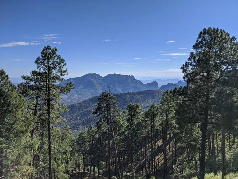
Once I got into Illinois, though, I was back to road trip fever.  Kankakee is only 50 miles from Crown Point and the state park there is rated one of Illinois' top five.  I wanted to check out the River state park, walk around for at least four miles, and drive on.

Kankakee River State Park is 12 miles northwest of the town of Kankakee and on both banks of the river by the same name, extending for 11 miles. Hiking and biking trails are only on the north end.  The southern bank is for kayakers and equestrians. Native tribes like the Potawatomi and Miami tribes called this river their home until they were removed after the 1838 Black Hawk war.  There are several historical plaques in the park describing the native tribes and then the French fur traders of the 17th century.

I didn't research where the three-mile hiking trail along Rock Creek is, the river that flows into the Kankakee river in the state park on the north end.  I found the paved bike trail -- the trail dominates the park --and walked 2.2 miles going  north, then turned around the way we came, occasionally walking down to the river bluffs to let Zeke drink.

It was a very refreshing walk that got me out of the humidity for a while.  There are mile markers every half mile and many unmarked trails that take one to the river.  The river here is like a much younger version of Starved  Rock SP, but with much smaller ravines and less dramatic canyons.

There were a lot of walkers and cyclists on the paved trail.  I enjoyed the walk, walking under shagbark hickory, Eastern hemlocks, Eastern Redbud  and River birch, all trees that are not native to Arizona.  These trees are all sweet-smelling, giving the bike trail a pleasant aroma and a dark shade. I kept Zeke on leash and only let him road when we were at the river.

I enjoyed the park.  People were fishing and wading in Rock creek.  I will explore the trail there another time.  The town outside the park, Borbonnais, is named after a French fur trader who lived in the area.  It's also home to Olivet Nazarene University, where the Chicago Bears do their training during their off season.  Ethan is a big Bears fan and I thought of him and missed him.

I didn't explore any eateries after my walk.  I got on I-57 and resumed my drive south, passing  corn and soybean farms. I saw a pretty sunset over Rend Lake.   I also saw at least two interstate marquees reminding Illinoisans to mask up.


I decided at the last minute to take a slightly different route back by stopping in Carbondale, where my friend SteveT lived for many years and home to Southern Illinois University.  Illinois gets hilly once one is south of I-70, but by the time I got into town, it was already dark.  The lone brewpub still listed as open in Google, Buckwater Brew works, had just closed when I walked in at 9pm and pretty much the rest of the town was shuttered for the night because of the covid pandemic.  The brewpub looked very cozy and I must visit on my next road trip! Southern Illinois and Indiana are so unlike the northern parts of their states.

With everything closed for the night, I opted to drive down to Giant City state park and park in the lodge parking area.  This proved to be a great idea, as the lodge also had many cabins spread apart with wide parking areas.  There were cars parked near the cabins but the lodge was closed.  Only the restaurant was open during meal times.  I never saw a person while walking the grounds with Zeke.  That turned out to be good, as pets are not allowed in the cabins. A statue dedicated to the Civilian Conservation Corps worker wore a blue face mask, accentuated by the lighting.  We saw deer, fox and raccoons before settling in for the night under the stars and loud cicadas.  I will explore the trails here in the morning before resuming my drive.