I finally had a day off to take all the dogs down to the canyon and let them romp away from mainstream. I wanted Zeke and Sammy to get some exercise and see how Sadie was doing. She's back to running again and looks fine, and even Minnie, who had been hacking yesterday evening, seems better. We think she had a wood splinter or cactus thorn caught in her throat.
We walked downhill rather than upstream. There was a target shooter uphill who had startled the dogs and the dogs started barking, so I did an aboutface and walked the other way, far enough to get down to where homes were along the creek. This also means being closer to other people and their pets, and farther away from a water source. The oaktrees here were badly burned and haven't had new growth come up. Broken asphalt from old roads now line the creekbed. The damage after the fire here was massive, and there are still signs of that destruction.
When I heard a dog bark, I turned around again and took the dogs back to the car. They all were panting hard, especially Minnie, and she was no longer hacking. Maybe she needed to run hard to expel whatever foreign object in her throat?
____
It was nice to take time away from the animal shelter and focus on my own dogs. I can't save all the dogs, but perhaps promoting the Facebook page will help get the word out that there are great animals in need of new homes.
https://www.facebook.com/pages/Friends-of-the-Huachuca-City-Animal-Shelter/134920913341965
Wednesday, October 23, 2013
Sunday, October 20, 2013
Mount Lemmon loop

I led the hike today. Expected weather for Mount Lemmon was 70F with a low of 36F. SteveS, SteveA, JohnS, Mac were my hiking partners. I brought Minnie but kept Sadie at home to give her more time to recover. Although she runs and fetches balls in our back yard, the last two hikes with her, she has been sluggish and slow. I had done this hike back in May 2010 with Sadie and wanted to see if the aspens that were regrowing since the 2005 fire had gotten any bigger since my last hike.

The Mount Lemmon loop is a combination of several trails: The Mount Lemmon trail, the Lemmon Lookout Trail, the Wilderness of Rocks Trail, back up to the Mount Lemmon trail and Meadow trail. The last three miles are uphill and can be exhausting. There are many loose rocks and tree roots along the way; one must watch one's footing. There were three GPSs on this hike and all three had three different distances of within a .5 mile.


From the pools we continued on the Wilderness of Rocks trail as it meandered up and around hills. This two-mile stretch is the most level section of the hike as it passes hoodoos and other interesting rock formations. Rappel Rock, a popular rock climbing wall, is visible along most of this section as its walls glisten in the sun.
John and SteveS were up front. I took the middle, making sure Mac and SteveA, who slowed down for Mac, was always within eye sight. Mac was steady but slow as we began our big ascent back up the Mount Lemmon trail at 1:45pm. Would we make it back to the cars by 4pm?

My right knee was slowing me down. I could feel every uneven step I took. My backpack also felt very heavy, as I had brought two gallons of water for Minnie and me, even though there were several creek stops along the Wilderness of Rocks trail (more than last time) so that the only dry part for her were the last three-four miles. The grade along this section started out moderate, but in the second mile we climbed up a long, steep section just before reaching the intersection with the Sutherland trail. The 2005 Aspen fire reached this area, but there were still small sections of mature Ponderosa pines that provided shade.


Mac and SteveA arrived by 5:20pm. Again the parking lot was filling up with people wanting to see the sun set. We just wanted to get off the mountain and out of the cold! There were some pretty colors around vistas as we drove the 26 miles back into Tucson, finishing off the day with dinner at Buddy's Bar and Grill on Houghton Avenue. Minnie slept in the truck and was quite content getting a break. What a trooper she is.
Everyone in the hiking group agreed this was a challenging and beautiful hike. I'm glad I had such good company.
Friday, October 18, 2013
West Hunter Canyon trail


Sadie was still not running like she used to, although she was better today than on Monday. She's still on the slow side. I do hope there is nothing wrong with her. She should have fully recovered from the hikes earlier this week.


This is a short, steep work-out. The creek by the old homestead is a perfect turn-around for the dogs. I let the dogs drink water, sniff around, and usually turn around here. (The trail officially ends here, with a more reclusive "illegal" trail going up a steep hillside to the ridgeline.) This steep side of the mountains has drastically changed since the 2011 fire. One can't tell anymore that a homestead was once here. The trail is heavily overgrown with weeds, weeds that grew from the seeds the Forest Service dropped over these mountains to prevent hillside erosion. The landscape has been reclaimed by nature.


Monday, October 14, 2013
Carr Peak with Sadie and Minnie

There were heavy clouds over the peak in the morning so I waited until early afternoon to get going. It looked like it could rain, but the clouds stayed over the mountains and avoided the valley. There were still dark clouds above when I drove to the trail head, but I had to get out and up that mountain. I knew I had missed the fall foliage but the elms were still turning yellow.
I got to the trail head at 1:17pm. There were several cars in the parking lot. There was already a sign on the parking lot dumpster that there would be no trash pick-up during the "government shut-down." The camp ground across the road, Reef Townsite, was also closed. Trespassers would be fined $5000 if caught anywhere within the closed-off area.

Fall was clearly in the air today. I smelled moist leaves. Sadie was looking tired and I hope it's just from yesterday's exhaustion and not that she picked up giardia from the canyon creek. I didn't see any diarrhea from either dog, though. She moved slowly and never ran, always staying near me and walking at a consistent pace. Minnie was her usual spunky self and running ahead.

The colors today were a mixture of yellows, lush green, and grey. The recent mountain moisture must be rejuvenating many of the fall flowers, or at least keeping the foliage alive.
I stopped at the Old Sawmill Spring to let the dogs drink. They did, and they also cooled off their paws in the mud. I noticed a wildlife camera on a nearby tree aimed at the spring. How long has that been there? What kind of animals is it looking for?

The aspens were already past their prime as we walked through, but the elms were still changing. There were still plenty of wildflowers that were slowly changing to seed. In two weeks even they will be dead and the colors return to blah browns and greys.


The dogs had fun. The clouds were spectacular today despite the wind. I didn't see any migrating hawks, though, or much wildlife in general. I was aware of bears but perhaps the dog's movements scared off the big animals ahead of time. Nature is slowly setting in for the upcoming winter.
I passed a USBP van going up the mountain road as I was going down. There was just enough light for that agent to get to the top in daylight and ready for the night shift.
I got back home by 5:30pm and learned that Kevin was laid off again because of the government shut-down. His recall only lasted three days! We will have to pinch our pennies for a while.

Sunday, October 13, 2013
Mansfield Canyon loop in the eastern Santa Rita foothills
Distance: 8.1 miles, loop hike using FR72A and FR4091
Elevation: 4708'- 6301'

 Mansfield Canyon was a heavily-mined canyon many decades ago in the southeastern Santa Ritas north of the town of Patagonia off AZ82. The mines are abandoned now (but not closed!) and ruins remain in the heavily-polluted creek. The mining trail is now a Forest road that is used as an ATV/hiking trail. This is an exposed, steep trail and provides views of the Patagonia area.
The Santa Rita mountains is area that is popular with equestrians, hunters, ATVers, mountain bikers and hikers. The foothills have long, steep grades. Oak trees and desert cactus provide what little shade there is in the upper elevations.
I hadn't been in this area for years. This was the first time Sadie or Minnie were here.
 It was a clear day and temperatures were expected to reach the 80s. I had packed two gallons for two dogs and me. I was assured there would be water in the canyon.
Rod led this hike. JohnS, SteveA, Mac, SteveS and I were in this group of six. For most of us this was our first time in Mansfied Canyon.
We carpooled from Sierra Vista and drove toward Patagonia 53 miles away, turning north on 1st Avenue just west of the Patagonia high school. The road then turns into a dirt road and becomes FR72 and part of the Arizona Trail as it meanders in a northerly direction toward Walker Basin, but we didn't go all the way up the road. We had to turn west on FR72A (Mansfield Canyon Road) for the trailhead another .8 miles up a rocky section. We decided to start the hike on the exposed ridge and to return via the more shadier canyon.
 It was almost 10am before we actually got started, because Mac was late and we waited an hour for him, reconnoitering the road and chatting. It was already getting warm when we finally got going and it didn't take the dogs long to feel heated. I stopped a few times to give them water, worried I'd run out since my jug was leaking. The first three miles of this hike were the hardest because of the lack of shade and the steep grade, but at least we had splendid views of the area. On a cooler day with some overcast skies this would be a lovely hike.
The road just kept going uphill as it switchbacked in long sections. The Hopkins Observatory and Mt Wrightson were to our north. I watched the dogs closely as Minnie was panting badly, considering dropping out and going low to keep them in the shadier canyon, but I stayed with the guys and walked the ridge up to be able to walk the cooler canyon during the heat of the day. The Dixie mine was our first mine and several building foundations were still visible.
 This turned out to be to our benefit, because once we reached the crest the walking became easier. There were more mature oak trees for the dogs. FR4091 is the road we took off FR72A to our left and descended into Mansfield canyon. (Had we stayed on FR72A we would have reached the Juniper Cabin area of the Mt Wrightson Wilderness, 7.6 miles away.)
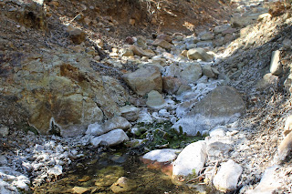
FR4091 is where there were many mines that have scarred the canyon here, leaving creek bed rocks with a white or yellow residue. The largest mine here is the Hosey mine, an active area from the 1880s through 1936. Pyrite is very visible in the tailings. We rested briefly here on large rocks. The dogs got their first snacks.
While there was cooling shade, there was also a lack of beauty as most of the canyon floor was ripped open from Hosey mine and everything downstream from that mine. Flood waters had added more erosion as we cautiously watched our footing. We had a late lunch along rocks in a dry section of the creek bed. Sadie was especially tired and lay near Mac as she napped.
The food energized us all. The dogs had two bags of jerky and snacks as we finished off the last two miles in an especially rocky downhill section. There were plenty of mines here, left open but with warning signs to stay out. The water here is used by grazing cows and all the cowscat I saw looked runny.
 The one big excitement for the dogs was chasing a herd of cows that was seeking shade under a large oak tree, a mile from the finish. I didn't see the cows fast enough to get them on their leashes, nor did they chase them for long. Another herd of cows ran up a side trail going uphill as I held back the dogs. This part was no fun as Minnie is a powerful dog when she gets the scent of cow, and I had to carefully watch my footing.
 The hike took us six (!) hours. We did a lot of stopping to rest in the shade. My dogs slowed us down but this wasn't a race anyway.
I was glad to see our vehicles at the end of the trail. Both vehicles were parked in the shade and no one else was around. No one else seemed to have been on this road all day as we saw no one.
While I am glad I did this hike and saw a new part of the Santa Ritas, the weather was too hot and dry for this hike. The wildflowers were already past their prime. There was little wildlife and even the vista was hazy. Had there been running water in the canyon, this would have been more enjoyable.
 We finished the hike in Patagonia at the town's historic hotel-restaurant, the Wild Horses. I had a cheese burger and a Diet Coke with lemon. The dogs napped contentedly in the truck with the windows open.

I definitely will be back in this area.
Elevation: 4708'- 6301'


The Santa Rita mountains is area that is popular with equestrians, hunters, ATVers, mountain bikers and hikers. The foothills have long, steep grades. Oak trees and desert cactus provide what little shade there is in the upper elevations.
I hadn't been in this area for years. This was the first time Sadie or Minnie were here.

Rod led this hike. JohnS, SteveA, Mac, SteveS and I were in this group of six. For most of us this was our first time in Mansfied Canyon.
We carpooled from Sierra Vista and drove toward Patagonia 53 miles away, turning north on 1st Avenue just west of the Patagonia high school. The road then turns into a dirt road and becomes FR72 and part of the Arizona Trail as it meanders in a northerly direction toward Walker Basin, but we didn't go all the way up the road. We had to turn west on FR72A (Mansfield Canyon Road) for the trailhead another .8 miles up a rocky section. We decided to start the hike on the exposed ridge and to return via the more shadier canyon.

The road just kept going uphill as it switchbacked in long sections. The Hopkins Observatory and Mt Wrightson were to our north. I watched the dogs closely as Minnie was panting badly, considering dropping out and going low to keep them in the shadier canyon, but I stayed with the guys and walked the ridge up to be able to walk the cooler canyon during the heat of the day. The Dixie mine was our first mine and several building foundations were still visible.

FR4091 is where there were many mines that have scarred the canyon here, leaving creek bed rocks with a white or yellow residue. The largest mine here is the Hosey mine, an active area from the 1880s through 1936. Pyrite is very visible in the tailings. We rested briefly here on large rocks. The dogs got their first snacks.

While there was cooling shade, there was also a lack of beauty as most of the canyon floor was ripped open from Hosey mine and everything downstream from that mine. Flood waters had added more erosion as we cautiously watched our footing. We had a late lunch along rocks in a dry section of the creek bed. Sadie was especially tired and lay near Mac as she napped.
The food energized us all. The dogs had two bags of jerky and snacks as we finished off the last two miles in an especially rocky downhill section. There were plenty of mines here, left open but with warning signs to stay out. The water here is used by grazing cows and all the cowscat I saw looked runny.


I was glad to see our vehicles at the end of the trail. Both vehicles were parked in the shade and no one else was around. No one else seemed to have been on this road all day as we saw no one.
While I am glad I did this hike and saw a new part of the Santa Ritas, the weather was too hot and dry for this hike. The wildflowers were already past their prime. There was little wildlife and even the vista was hazy. Had there been running water in the canyon, this would have been more enjoyable.


I definitely will be back in this area.
Subscribe to:
Posts (Atom)