Saturday, January 30, 2021

Ivanhoe mine shaft

The rain forecasted for yesterday never came.  The storm stayed north of us.

Ellen and I ended up not hiking the Cottonwood Peak route the hiking club had on today's schedule.  Rod was now not leading it after his wife Cassie came down with a cold. In case that turned out to be the coronavirus, though, he opted to stay home and let SteveS lead the hike.  Rod told me Steve still had the intent on hiking Cottonwood Peak.  After the deep snow up Thompson saddle on Wednesday (6786'), I was in no mood to posthole to 7100'. My Merrell boots are still wet from that hike and I need to get new gaiters as well.  When Ellen told me she was exhausted after attempting to hike up Huachuca Peak on Friday with Rob (they didn't make it to the peak because of high snow drifts), she told me she needed to take it easy today.  And that made it easy for me to bow out, too.  We will bag Cottonwood Peak another time, when conditions are more favorable and it is more of a hike and not a physical strain.

I didn't have any concrete plans for today other than to take the dogs somewhere snow-free but cool. I had stuff to do in the kitchen, and I certainly have a lot of cleaning to do in the living room, but for today I just wanted to get out and enjoy the 50F sunny weather. I then thought of exploring the Gold Hill area some more--there are plenty of mines I could explore--and when Susan asked me at 10:30am if I was hiking anywhere, I suggested the Gold Hill area.  It's hilly but not challenging, and hopefully there would be some water in the drainages after last week's storm.

This hike gave me the opportunity to try out my new sand-colored Keen Explore Vent Mid hiking boots, made from mostly breathable mesh best suited for non-snowy terrain.  I like Keen shoes because they always fit me nicely; there is no "wearing in" time with Keens.  These are also light, with grippy rubber soles.  These are replacing my Clorts.

By noon we were on our way to the trailhead, driving in convoy fashion with five happy dogs in tow.  We saw one woman and a dog start ahead of us on the trail, but we never saw her on the trail.

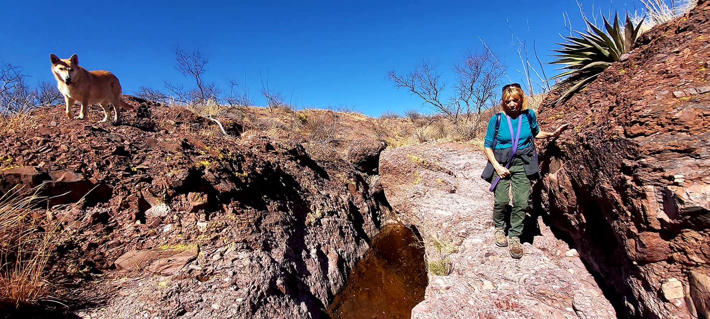
The trail felt damp the entire way.  The color was still a monotone khaki, though, with no improvement here after the rain. I'm sure this area got hit hard with snow, but the only snow left now is in shady spots on the northern slopes.  We started on the unmarked trail I went on the last time I explored Patio Peak earlier this month, but when we got to a hilltop on the main road and saw the water in the drainage below, we decided to bushwhack down the hill so that the dogs had water. It was such a contrast to be in the drainage; it was much more appealing to the eye.

The drainage adds some contrast to an otherwise dull trail to Patio Peak. The drainage curves in a southerly direction, travels around the rocky mounds, and then connects with an easterly road that then connects to the main road to Patio Peak.  I may take the group up this route when I lead the March 6th hike to the peak, creating a loop hike with some diversity.


The dogs concurred with this decision  to follow the drainage and we could tell they were having fun.  Zeke stayed close by but the other dogs were busy chasing each other, running up and down the rocky hillsides, in between ocotillos and cow patties.   Despite the many cow patties, we didn't see any cows, just crazed birds and a few daring desert hares.  Some of the water holes were deep enough for Hansel to swim in, and he took advantage of that to stay cool.

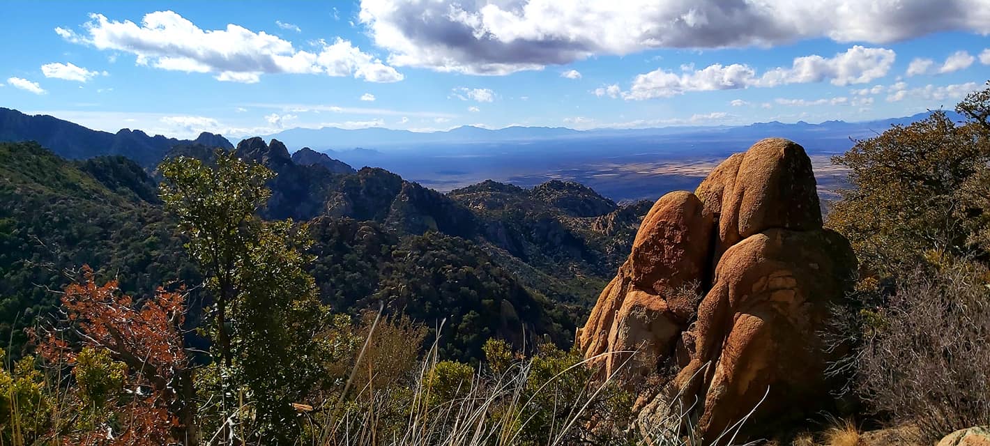
The farther south we walked in this drainage, the more interesting the rock formations became.  Amazing how energized the area now looked after some moisture, despite no shade trees.  The conglomarate rock appeared to have some fossiled wood in it.  And farther on we found big boulders with geodes protruding from them, eroded smoothly from monsoonal rains over the millennia.  We were in a hidden paradise!  Even Susan suggested I should lead a hike here with the group now that we have explored the path.  I'd love to explore this area even more once the ocotillo go into bloom in early March.  I hope we get a few more intense rains, too, to make that happen.


We could see the mine tailings once we had a clear view of the south.  The tailings were our destination, a two-mile hike from where we had parked.  We stayed in the drainage as it meandered south, then took an old mining road up to where the tailings were.  We walked around the fenced-off shaft that I learned later was the old Ivanhoe mine shaft drilled in 1922 to a depth of 375'.  Despite the large tailings and the flat top by the shaft, we didn't find anything else.  All the structures have been torn down and no relics remain.  I did see what looked to be more smaller mines higher up the hillside, but we opted to leave those for another day to explore. 

We rested on our return walk back in the drainange, sitting on shaded rocks and noticing the boulder we were by.  The giant boulder was full of geods!  I picked up some trash here, all of which originated in Mexico.

We went back along the drainage to stay near water, but then saw another ATV trail going up a hillside.  My tracker showed that trail would lead us to the main trail we started on, so we looped back to the cars via the "high water trail" with  views of the Warren mine and the homes off Yuma Trail, where we parked.

We had hiked just under five miles in 2.5 hours, and an elevation gain of just 763 feet.  I had accidentally turned my tracker off for a good half mile before noticing the error, so the official recording ended up with 4.4 miles.  (We had hiked 2.6 miles to and around the mine shaft before turning around)  

https://www.bisbeeminingandminerals.com/ivanhoe-copper-company-?fbclid=IwAR0bGkRmcsjGy5gUv9UQM211P26KBKu47SM_HbOF4JeA7p42_NGDw6lnh4U

Global cases 103,228,328
Global deaths 2,240,630

The US infection rate has dropped 33% since 9 Jan 21
US cases 26,655,715 (+139,089)
US deaths 450,381 (+3233)
AZ cases 753,379 (+5119)
AZ deaths 13, 098 (+76)
CA cases 3,296,912 (+15,595)
CA deaths 40,682 (+379)
IN cases 624,959 (+2334)
IN deaths 9967 (+42)
PA cases 844,519 (+4631)
PA deaths 21,658 (+140)


Thursday, January 28, 2021

Perimeter trail under a full moon

I decided in the morning to walk a short section of the Perimeter trail after school.  The full moon rose at 5:56pm and I invited Ellen and Susan to join me.  Ellen and Rob showed up and I brought the pack.  We walked 3.12 miles in 1:15 hours.


It was a warm day, reaching the low 60s.  Now all the snow and ice in the streets had melted and dirt roads were wet from the icemelt.  The Perimeter trail was also mostly snow-free so I chose that as the walk.  I wanted to avoid anything higher that would get icy after a refreeze.  This was a good choice

We had an overcast sky for most of the day and I wasn't too sure if we would see the moon rise.  By late afternoon most of the clouds had thinned out except along the eastern horizon.  Sure enough, we didn't even see the moon until 20 minutes later, when it appeared behind the clouds.


Ellen and Rob said the dogs behaved well, staying mostly up front with me.  The pups were busy chasing each other while Zeke and Sweetie stayed behind me.  We never met anyone else so the dogs being off-leash weren't a problem.

***

Global cases 102,227,484

Global deaths 2,214,740

US cases 26,338,555 (+176,748)

US deaths 443,769 (+4445)

AZ cases 743,232 (+4671)

AZ deaths 12,819 (+176)

CA cases 3,260,175 (+19,252)

CA deaths 39,576 (+689)

IN cases 619,995 (+2819

IN deaths 9879 (+34)

PA cases 830,295 (+6079)

PA deaths 21,356 (+194)


Wednesday, January 27, 2021

Thompson Ridge in the snow

Ellen loves snow.  As a native Arizonan, she enjoys hiking in virgin snow.  While we didn't have time to hike Carr Peak today (the Forest Service closed the road two days ago), I suggested we hike up to Thompson Ridge in Ash Canyon.  It's a north-facing switchback with a steep grade, offering a challenge and views for the hiker in a short time.  She had never been up this old mining trail.

Wednesdays is our early release day.  Students are done at noon and teachers then have professional development until around 1:30pm.  I kept up with grading so at 1:30pm, I left to pick up the dogs, get into my snow gear, and meet Ellen at 2:15pm at the mouth of Ash Canyon.  I had all four dogs anxiously waiting to get out and hike for 15 minutes before she did arrive.  I then lead the way to the trailhead, but just past the Ash-Lutz Y in the road, the ice on the road got to be too much for my Honda and I lost traction, so we turned around and parked at a safe turn-off.  We got started at 2:30pm, a good time as it was still sunny and warm.


Today's high was 45F and some of the snow was already melting (only to refreeze after sunset).  I didn't have my leashes because I had hoped to start at the trailhead.  There were a few families building snowmen in the snow but the dogs left them alone.

The dogs were loving the snow, especially Hansel.  He and Sweetie would leap into the deep, fluffy snow off the trail, run down a slope, and dredge back up the trail.  Hansel had no trouble, but Sweetie, being the smallest of my dogs, was having trouble in the deeper, steeper sections.  At one point early on, she got separated from the pack and traveled back down the hill.  We could hear her barking and it sounded far away.  So she either decided to walk back to the car, or her barking was muted by a low spur she was in.  We walked back a bit, I yelled out her name, and just as I was ready to walk back down the hill to find her, she came leaping out of the snow. Whatever happened to her, she stayed close after that.


Tire tracks made the first mile up the hill easy, but the tracks disappeared before we reached the gate a mile up.  From here on up it was all virgin snow, 8-12 inches.  The exposed parts had little to no snow, so it was not a constant slog. We all took turns blazing the trail and postholing in the snow.  The higher we got, the deeper the drifts became.  I wasn't about to give up, though.  As long as we had enough daylight for the return hike and the snow was manageable, I was ok with the challenge.  


It took us 1:31 hours to get to the ridge in the 2.7 miles. The saddle was snowfree and a relief for us all. My feet were damp but not yet cold as long as I was moving.  The dogs continued to chase each other (they have no concept of "taking a break).  Ellen enjoyed the views.  We took a few photographs and then started our return hike.  I'm sure the dogs were happy to get back to the car, as now they stayed close.

Two families were still sledding on the road as we walked past.  The ice was now freezing and the snow was behind the mountains.  We got back to the cars, still safely parked off the road, at 5:30 as the near fullmoon was now visible from the east.  It had taken us only an hour to walk back down.  We had timed this hike just right, even with the two added miles.

Another storm is due in Friday and may add fresh snow to the higher elevations, so I'm glad I got my annual snow march in early.  If we had a foot of snow at 6786', I'm curious how much is on Carr or Miller Peaks.

***

Global cases 101,606,537

Global deaths 2,198,881

US cases 26,166,371 (+145,688)

US deaths 439,521 (+3880)

AZ cases 738,561 (+5918)

AZ deaths 12,643 (+195)

CA cases 3,233,200 (+17,882)

CA deaths 38,634 (+673)

IN cases 617,176 (+2230)

IN deaths 9845 (+38)

PA cases 824,216 (+5865)

PA  deaths 21,136 (+221)

Tuesday, January 26, 2021

Snow!

 Yesterday was cold and blustery and I fell short of my daily mileage quota of 5.5 miles, and before I left school yesterday, the school district told us we were all teaching from home today because of a forecasted 5-8 inches of snow on the ground in town for Tuesday.

It began raining at around 5pm yesterday, but at 35F, the snow was melting as it hit the ground.  It didn't turn into snow until around 8pm.  And it snowed all night long.  Our winter weather advisory was extended until 8pm today.

When I got up at 2am today to look outside, there were at least three inches of snow on the ground. Since we were told to teach from home and the first period today was a planning hour, I took the pups, Minnie, Zeke and Sweetie, down to the maintenance road for a quick romp.  

That's when I learned how bad the roads were.  Hereford Road wasn't plowed or sanded  (not that I expected that) and SR92 was no better.  In fact, all that rain yesterday had frozen to the pavement and the streets were completely iced over.  I saw a two-car accident at Ramsey Road and SR92 when I drove to my parking area on the cul-de-dac and emergency vehicles were still there when I drove home an hour later.  Drivers were moving at 30mph.  It looked like a scene from Chicagoland in a blizzard. More snow clouds were moving in from the mountains and the south.  It was the perfect day to stay inside.

People were coming to the area to try donuts on the ice.  I didn't want my dogs to get hit by an out-of-control car so I stayed on the dirt road and  walked south to the maintenance road, checked out the dry stockpond which was covered in snow, and walked back to the parked Honda. My feet had gotten wet enough in that short distance to get cold and stay cold all day.

The pups didn't seem to mind the snow.  They chased each other as usual.  Zeke and Sweetie walked through the desert without a care.  Only Minnie seemed to whine in pain.  I need to have her checked out.  Every step she takes is an effort and her steps are short.

I got back home at 8am and spent an hour trying to get my feet warm before class. I never did go back out into the snow for a second round after school. I only walked 1.5 miles today, the shortest distance this year. The snow in the backyard remained on the ground by nightfall, the first time in 16 years here that I've seen that.  Normally snow melts by noon. Even after the storm had passed in the evening, I opted to stay inside.  It was the perfect day to take a break from all that walking.  I'll be back on the trail tomorrow when Ellen and I attempt Thompson ridge tomorrow.


***

Global cases 100, 406,685

Global deaths 2,163,573

US cases 25,861,545 (+153,681)

US deaths 431,392 (+1887)

AZ cases 727,895 (+5321)

AZ deaths 12,239 (+1)

CA cases 3,199, 895 (+27,306)

CA deaths 37,527 (+467)

IN cases 613,228 (+9728 (+2189)

IN deaths 9728 (+12)

PA cases 813,665 (+4714)

PA deaths 20,702 (56)


Sunday, January 24, 2021

Winterstorm coming!


We had rain on January 20th in the evening, then again overnight into the 21st.  It was a steady rain but nothing that would get the San Pedro river rushing high, or the stockpond refilled.  This storm that came through on my weather app this morning looks promising.

Since rain was forecasted for 7am, I went ahead and took the four hiking dogs (Sadie and Minnie stayed home) down to the maintenance road for a quick romp.  Walking that road east at sunrise is still the best area for a wide-angle sunrise view.  This morning the eastern sky and the mountains were all shrouded in grey clouds, though, so the only time I saw the rising sun was briefly as it poked over the Mule mountains before disappearing again.  I even saw snow above 6000'!

It was a steady drizzle and not a soaking rain.  The ground felt damp but not saturated.  I ended up walking the dogs for three miles up and down both dirt roads, watching a full rainbow come and go and the wet grass glisten in the early sun.  I was damp and cold, but the dogs had fun and that's all that matters.

I spent most of the morning back home trying to warm up.  I felt damp and cold all day. More rain and then snow was in the forecast, but there was a dry window between noon and 3pm, so Susan and I got together at 1pm for a river walk.  This time even Minnie came, but again Sadie showed no interest. Storm clouds were over the peaks and to the south, but we had dry weather over us, albeit a cold wind.  It didn't seem to bother the dogs, though.  Gretel seemed quiet and Susan even noted that.  She wasn't racing after Hansel although she still liked to ambush him.

There's something invigorating by walking in cold, windy weather.  To Susan it feels like being back in England, but what I like is the warm feeling I get being back indoors after a cold romp outside, and the sweet citrusy smell of lemon-ginger tea.  

We got another 2.25 miles in.  I got home by 3pm and as forecasted, the first flakes of snow began to fall.  It's going to be one very cold week and a week staying warm drinking hot herbal teas.

***

Global cases 99,529,812

Global deaths 2,145,035

US cases 25,579,471 (+184,052)

US deaths 427,713 (+3649)

AZ cases 715,357 (+7316)

AZ deaths 12,170 (+169)

CA cases 3,151,617 (+23,126)

CA deaths 36,820 (+533)

IN cases 608,519 (+3093)

IN deaths 9,693 (+51)

PA cases 805,242 (+5336)

PA deaths 20,564 (+199)


Saturday, January 23, 2021

Abril mine from Soren Pass

Distance: 8.7 miles 

Elevation : 1072'

Significance: exploring mines and enjoying the views

https://www.strava.com/activities/4670332222


This was the big day! After taking Ellen and Rob to the Abril mine on New Year's Day and them enjoying the mine so much they wanted to do it again, we finally had a good date with good weather (upper 50s early afternoon but with a windchill) to go back to the mine for some real exploring.  I took a fresh headlamp and brought Zeke, who wore a bright orange vest and a collar lamp himself.

We met at Fry's in town at 8am.  We were all punctual and left promptly.  I ended up driving myself but told Ellen that if Middlemarch Road got too rutted, that I would stop and continue on in her vehicle.  I have not driven Middlemarch Road past the Forest Service sign to Soren Pass since 2015, when I last went exploring there with Zeke, Sadie and Minnie.   It never should have taken this long to come back here!  I love exploring the Dragoons, but it's at least an hour's drive each way, and the rocks get too hot when it's warm out, so winter is the only time I can enjoy this mountain range.

The only obstacle today were some obstinate cattle in the middle of the road that refused to make way for us.  I had to make Zeke growl before they were able to move for us so we could safely drive on by.  So much for the effectiveness of cattle guards!

The road was surprisingly in good shape for my Honda.  I was even able to drive all the way to the old camp site in my Honda, 1.4-miles from the turn-off!  It seems the road had been graded some, too, and a new barbed wire fence installed just before getting to the old camp.  The old windmill is still there.  The water retainer was full of algaeic water.

We had no one on the trail near us at this point.  We were just three hikers walking the old mining road to its dead end. It was chilly, too!  I put on three layers at home but took my rain jacket and a sweat shirt in the Honda.  I put on the sweatshirt for added warmth and then never took it off!  Even when it did reach the upper 50s on our return hike, the wind chill kept the temperatures down nicely.  It was 39F when we started our hike at 9am, walking up a. former mining road surrounded by oaks, agave, cholla and lots of hillside shindaggers.


Ellen was totally enjoying this hike.  We entered two small mines right off the road but neither was very long.  Zeke followed me obediently without fear.    The views from the pass impressed her and Rob, and even more exciting was the mine we found up a hillside that we went into.  It had a large opening!  We didn't enter the mine from here due to the steep and loose rock.  Ellen said this opening is a big air shaft that we came near the last time we were here three weeks ago.  We went back out, then followed a faint foot trail that ended up by another mine shaft behind a wooden cable tower.  


We rested here a bit to drink water and have some snacks, then entered the mine from here.  The tunnels were solid rock and I never felt nervous.  We followed some arrows and ended up circling around inside, hitting cave structures formed from dripping minerals off the ceilings.


We avoided all the ladders and straight shafts.  There must have been a massive rock slide inside that closed off some tunnels, but the main adits were walkable.  Others come here to explore, as evident by the many beer cans and bottles on the mine floor.   The broken beer bottles bothered me, as the glass is hard to pick up. I don't mind picking up whatever trash can fit into my backpack, but my pack was packed to the hilt with food, water and first aid supplies that I had no other room.


This mine tunnel is not visible from the main road as it's behind the cable tower and overgrown with shrubbery, but this was a huge, complex mine operation at one time.  We only explored the safe passages; who knows what else is underground here. My cellphone doesn't take good low-light photos, and so many pictures didn't turn out.


We basically did a big loop in this mine, coming out by the adit that we had entered from three weeks ago.  We then took the mining road back to the pass.  This is an exposed trail and even though the fog had cleared, the wind chill was back.  We had another snack at the campsite by the pass before walking back to our cars.  We were now just north of China Peak (a hike scheduled for February 27th with the hiking club), and we noticed a flag waving from the peak.  I told Ellen that was most likely from an ATV that had made it to the summit.

It was now approaching 2pm.  Several campers had set up camp at a few other side roads.  Ellen treated me to some chocolate muffins as part of my birthday surprise, and as we stood by our cars to eat, three more jeeps thundered on by.  Thank goodness we were not driving back yet, as the road to Soren pass is not very wide!  I noticed more mine adits near the Middlemarch Road turn-off that we need to explore at a later date.


More traffic was on Middlemarch Road (FR345) as we made our way way back to SR80.  It was after 3pm now and a Cochise County Sheriff Deputy vehicle came barreling down the road, blowing up a dust trail and flashing its lights.  Then a county vehicle followed, and then a second  CCSD vehicle roared on past us.  What had happened?   Ellen told me later two 27-year-old hikers had gotten lost in the Cochise stronghold when they took a wrong turn, but that was two days ago. I later learned that a 65-year-old man fell off a horse on some remote land and needed to be sent to a hospital.

I got home just as the 4pm NPR news came on the radio. Long-time interviewer Larry King died today, after being hospitalized for covid late last year.  He was a long-time beacon on CNN back in the 80s.  He was 86 years old.  And yesterday baseball great Hank Aaron died at age 87.

The dogs were happy to see me back home. I was too tired to walk them, but if it's cool and overcast again tomorrow, I may just take the whole pack back to Bisbee and explore the mining road that goes east of Gold Hill.  Weather will get cool and rainy tomorrow evening and snow is even in the forecast for Tuesday!


My Clorts hiking boots, which I bought on sale via Amazon four years ago, are now too torn to be effective.  These boots were comfortable, but the leather suede did not  survive my hiking style.  The leather was slowly coming ripped from the sole and today a big rip from the seam into the upper arch made these boots too airy for safety.  I'll never buy Clorts again as the boots I had were poorly made with cheap leather and low-grade rubber.  I usually wear out hiking boots via the soles, but these boots have worn down all over!  I do have new boots coming via sierra.com, though.

***
CDC is now reporting several variants of the coronavirus, but the UK variant appears to be very contagious and very deadly.  There is also a South African variant and a Brazilian variant and any of them may cause another surge of infections and deaths

Global cases 99,376, 580
Global deaths 27,711,655
US cases 25,566,737 (+184,052)
US deaths 427,635 (+3649)
AZ cases 715,357 (+7316)
AZ deaths 12,170 (+169)
CA cases 3,151,617 (+23,126)
CA deaths 36,820 (+533)
IN cases 608,519 (+3093)
IN deaths 9693 (+51)


Monday, January 18, 2021

Dry Canyon, Whetstones

Distance (two routes) 4.7 miles)

Elevation gain: 1079'

Significance: limestone rock walls, fossils, views

https://www.strava.com/activities/4642669569

https://www.strava.com/activities/4643054591

Exploring this canyon with its geologic uplifts has always been on my bucket list.  Ellen suggested it and I went along.  Getting to this area requires a high-clearance vehicle, so we went in her Toyota Cruiser.

The hikes from the last two days tired me out and I overslept for our 0800 hour meet-up.  I was tired all day but not sore.  The high today was in the low 70s and that didn't help my fatigue, either.

Dry Canyon Road is the most southern road into the canyon from SR83.  The road starts off as a fairly level road in the flat area, surrounded by dry campsites and catclaw, ocotillo, agave and desert shrubs.  The taller reefs of the Whetstones are to the north.  A popular target shooting area is at the intersection with Dry Canyon Road and a more rutted road that follows the eastern foothills. We stayed on Dry Canyon Road going in a westerly direction, following a dry wash and more geologic uplift.  We parked the Cruiser near the trail and hiked in from there, following the wash, then crossing it, as the trail approached the rock wall.


Hansel wore the bright yellow cape from yesterday.  He seemed so at ease around us, walking ahead but staying nearby.  Only once did he bolt to chase after a deer.  He was panting fast in the rising heat.

The trail we were on was constructed by University of Arizona students-rockclimbers.  The singletrack travels to "The Dry," a large shelter cave high above the uplift.  This trail then hugs the rockwall as it quickly gains altitude.  Climbing gear was stashed in crevices.  Hooks in the rock and a rope were dangling from the cliff.


The views to the east were impressive.  This area would be stunning in a wet winter and spring, but today it was looking parched like everything around me has been looking for a while. The limestone we were walking on contained various fossils (crinoids); I can visualize this canyon once being underwater.


We couldn't go far without safety gear, and I didn't want Hansel in any danger.  We rested near The Dry and then descended the way we came, then rested in the shaded wash to let Hansel recover. He seemed so at ease around Ellen, coming right up to her to lick her.  When we separated briefly, though, he always stayed with me.

The wash was overgrown in parts.  I told Ellen I would head toward a large tank while she continued along the wash to explore some boulders.  Near the tank was what I thought were some mine tailings, but it turned out to be brittle slate, slate that I discovered was all along the mountain range.  Ellen pointed out dykes of limestone protruding along the hillside. promising that we will be back to explore more of this canyon.  We finished off the short hike looking around a shaded wash with boulders and discovered what we think is an animal den. We had gone a mere 2.7 miles when we got back to the Cruiser to snack and rehydrate before resuming with a second walk on another unmarked dirt road.

"You could bring your pack here!" she said, and I agree.  We never came across other people until we were ready to start a second walk a mile away.  A red pick-up with two women rumbled on by.  We waved at each other as I held on to Hansel's collar.  This second dirt road dead-ended a mile up a hillside also covered in slate.

We were surrounded by limestone all around us, but none of the hills had trails.  Exploring this range would require a daylong hike up the uneven terrain.  Even Ellen's caving club hasn't been back there to explore.  Most of the mouth of the canyon is reserved for target shooters (who leave quite a bit of trash near the mouth of the canyon) so perhaps that is why few hikers venture into this area.

We came across Frank and Lynn, a hiking couple I first met via the SV Hikers.  Frank was Kevin's supervisor ten years ago before he retired to spend more time with Lynn traveling and hiking.  They had come to target shoot and then walk along the dirt road.  I hadn't seen either in a few years.

Our last stop before leaving the canyon was a stop at a cross, in memory of a 17-year-old migrant  who had died here in 2005

We had hiked just under five miles and now I was officially tired from this weekend's adventures.  It was 71F when I got back to my Honda at Ellen's place, and then I drove home only to meet Susan for another 2.5-mile slow walk along the river at 2:30pm.  Again Sadie opted to stay home as we took our time to let the dogs relax in the water.  Minnie loves to walk in deep water, and I'm sure it helps her arthritic joints. Winds were picking up, too, with interesting lenticular clouds high above us.  One briefly looked like a duck head.

I have hiked 26.87 miles over the three-day weekend and by the end of today, I felt them!


***

Global cases 96,197,155

Global deaths 2,062,070

US cases 24,626,389 (+150,779)

US deaths 408,623 (+1440)

AZ cases 679,282 (+5400)

AZ deaths 11,265)

CA cases 3,024,082 (+31,501)

CA deaths 33,739 (+192)

IN cases 592,709 (+2498)

IN deaths 9340 (+30)

Sunday, January 17, 2021

Carr Peak with Hansel and Sweetie

It was the perfect day to bag Carr for the month.  Wind was calm all day and the high was in the low 50s near the peak in mid-afternoon.

I expected to be very sore after yesterday's long, strenuous hike, but when I got up to get my coffee in the morning, I felt fine. Even my back had recovered.  That's when I knew I could bag the mountain in the afternoon and take Hansel and Sweetie.

I wanted to give Zeke a rest after yesterday's hike.  While he wanted to go with us today, I saw how exhausted he got during the hike.  His passion is still there, but his body is slowly aging.  It's time to give Zeke more rest and open up opportunities for other dogs.

I decided to chance it with Sweetie.  This was her first time up Carr Peak and she did better than expected.  I was nervous taking her: would she run off, harass other dogs, or fight with Hansel? I wouldn't know without giving her a try.

Sweetie and Hansel did briefly fight in the back of the car as I was driving up Carr Canyon Road.  When Sweetie fights, she goes all out and the last thing I wanted was two dogs fighting in my car.

"Stop that right now or I'm turning this car around!" I yelled at them both.  I meant it, too. They both calmed down right away. They don't like it when I yell.

I drove up to the Sawmill trailhead and faced three cars with out-of-state plates that were making the parking area their personal campground.  Two cars were from California, the third, on the other side of the lot, from Oregon and the driver was sunning herself in a camp chair facing the east.  I was a bit annoyed but didn't say anything, and that was for the better as both dogs jumped out of the car and ran up to the people.

It was 57F at the trailhead with calm winds and near-clear sky.  I took off at 1:30pm.

I never put either dog on leash although I had two in my backpack.  I watched both dogs the entire hike, especially Sweetie who ran all over the place exploring in that first mile.  I stopped a few times to call her and wait for her, wondering if I was going to have to stop and wait for the entire hike.  She did calm down once we got on the main trail and then always stayed within eyesight.


The mountain was full of people, both in the lower picnic areas and near the trails.  I made way three times for couples, going off trail with the dogs so that they wouldn't feel intimidated.  Both dogs came right to me and the only time Hansel got goofy was when we passed another young dog who was excited to see Hansel.  Once I passed the father-son-dog trio, I had the whole trail to myself.

I timed the hike well.  There are always fewer people on the trail in the afternoon, but the other thing I liked was the cooling shade for the dogs.  Hansel wore a bright yellow reflective vest I put on him to keep his back cool  The sun was already low when I started, but it got lower within the hour so that the only sun was at the top, and by then it was in the low 50s.

Sweetie took her new experience in very well.  She looked in awe of everything, as if she were seeing the world from this high up for the first time. She also got along with Hansel, even when he snapped at her when he walked out of the woods with a deer leg in his mouth that he wasn't about to share with her. 

I noticed ice crystals on the northern slopes above 8000'.  There was no snow or moisture anywhere else, though.

We got to the peak in 1:47 hours, which was pretty good considering I stopped once for water. I fed each dog a pouch of wet food as we sat by the shrubs and then discovered that the ladybugs were still there!  They came out of the crevices in the rocks at the peak, using the warmth the rocks emit as shelter.  I have never seen ladybugs on our peaks this early in the year.

I didn't stay long on the peak. It was 3:48pm when we resumed our return hike.  We got back to the car after 5pm.  The out-of-staters were gone, too.

I fed Hansel a can of Pedegree but didn't have a second can for Sweetie like I thought.  She looked hurt and I felt bad, so I stopped at the Speedway gas station to get us all one hotdog as reward.  Sweetie ate hers up right away.

While the hike didn't offer any color in flowers or new growth, I am very pleased with how both dogs behaved. Hansel behaves better when he is around an older dog. He'd be all over the trail if I had brought Gretel.

We are now expecting rain in the Tucson area starting Tuesday night and lasting into next weekend.  I hope we get at least rain from this winterstorm that is expected to drop a half foot of snow in the South Plains, as our land is parched.  Evergreens are dropping leaves to save themselves.  I opted to bag Carr this weekend so that I wouldn't need to hike in the snow, and I hope we do get snow in the mountains.

https://weather.com/news/weather/video/here-are-four-things-were-watching-in-the-weather-this-week

***

Global cases 95,647,676

Global deaths 2,051,426

US cases 24,481,998 (+162,002)

US deaths 407,202 (+1824)

AZ cases 673,882 (+6981)

AZ deaths 11,266 (+208)

CA cases 2,994,519 (+57,895)

CA deaths 33,593 (+766)

IN cases 590,211 (+3162)

IN deaths 9310 (+23)

PA cases 772,747 (+5643)

PA deaths 19,346 (+117)


Saturday, January 16, 2021

Cottonwood Canyon, Whetstone Peak Ridge Loop Trail (Whetstone Mts, AZ)

Distance: 10.6 miles

Elevation: 4709' -6665'; 2429'

Significance: oak-pinon canyon with creek; views from saddle

https://www.strava.com/activities/4632406642

https://www.strava.com/activities/4632406642

The Cottonwood Canyon trail #360, which joins the Guindani Trail in Karchner Caverns SP two miles up the trail when walking counterclock wise, is a beautiful oak-pinon agave manzanita scrub forest.  I was last here five years ago with HollyO and MaureenL and Sadie, but we turned around when we couldn't find the trail after the first mile.  I've been wanting to go back there since to explore the trail some more.  When Rod hosted this hike today, I jumped on the chance. I invited Ellen. This is her first time here as well.

We met in town at the Pizza Hut Bistro and then at 0800 hours caravanned to the state park where Rod, the official leader, was watiing for us.  We were eight people: RodC, SteveS, DougB, JohnS, BillC (first time we meet),  JimA, Ellen and I.  This is my first hiking club hike with the old gang this year.

I was dressed for 55F weather, but both John and Steve warned me that the forecasted high would be in the 70s.  That is not what my weather app told me earlier, but since it was already 44F at 8:30am, I took their word. I left my stuffed vest in the car and I'm glad I did.  I removed my wind breaker shortly before we got to the saddle and hiked the rest of the way in my beloved white hiking shirt with a white tshirt underneath, with jeans to prevent me from getting scratched up from shin daggers. 

Cottonwood Canyon had been chosen by the Forest Service to be Proposed Wilderness Area, or PWA.  No roads go into this canyon. The trail #386 meets up with the Guindani trail two miles into the hike. In a normal year, there is plenty of water.  Today the creek, springs and trough were all dry. Rock walls from the hillsides would create dramatic waterfalls.  I would have to come back here after a rain to explore the beauty.   Lots of bears live back here, as evidence in the over 50 piles of bear scat along the trail.  The more remote location had made this canyon a popular smuggle route going north, but today we didn't see any migrant trash.


We met a lone trail maintenance man near the 3.5-mile mark.  Originally from Pennsylvania, he moved to the area and single-handedly cuts down the overgrowth each spring.  The trail was easy to follow with the cairns along the way.  We only briefly lost the trail twice, and both times Ellen saw the cairns when the rest of us did not.


At 0.25 mile from the saddle we rested briefly at a dry trough.  I gave Zeke his water. (Ellen took photo)

We arrived at the saddle in 2:15 hours.  We could see to the northwest, with Rincon peak in the distance and the town of Mescal and I-10 below.  The trail here continues downhill few more miles to a green tank, which we could see below.  

A barbed wire with opening divides the national forest from private property at the sunny saddle.  We rested and had lunch here before starting our return hike via an ascent up Whetstone and East Peaks before the brutal descent and last two miles.


We followed a faint trail along the barbed wire and now were walking north, up an exposed hillside with plenty of shin daggers and catclaw at the peaks.  The soil itself was firm, though, and allowed for secure footing. From here we could see all the tall peaks of the Whetstones, this pristine beauty.  We rested near Whetstone Peak, where ladybugs adorned me, before now turning southwest along a ridgeline. 

We were now heading to our second peak, East Peak.  We could see parts of the Guindani trail and Rickets mine to our northeast.


 We saw a group of about eight people below in another saddle, all wearing red shirts and huddled by an oak tree.  Who were these people and what were they doing here?  We sure have met quite a few people in a remote canyon!  As we got closer to them we learned they were a search and rescue team out of Ajo, AZ, Paralelo 31, who were looking for a body near a water tank farther downhill.  We had seen the tank but didn't descend yet.  Paraleo 31 travels every month to find bodies of reported missing migrants so that families can have closure.  They are volunteers who pay for their own expenses, but do take donations as this work is not easy.  They all looked exhausted.  We chatted a bit before departing, we going uphill for a bit as they descended to the tank.  From this high point one can clearly see the north-south elongated uplift in the rock, a mixture of sedimentary and granite.

We were now on the steep descent once we made it past East Peak, and Zeke and I were getting exhausted.  The grade at times was 34%.  We advanced only 1.4 miles in the last two hours and we had the warming afternoon sun over us.  My knees were starting to hurt.  Rod fell and injured the same hand he broke a few years ago.  We didn't get back on tierra firma until we hit the 9,4 mile mark.  This last mile was at a much more humane grade, but but now we were all exhausted.  We stopped briefly at an old  ore processing mill but by now we were all in going home mode. We got to our cars shortly after 4pm and I attacked my cranberry juice while Zeke got his canned meal and ice water.


All of us were exhausted.  I thanked Rod for leading this hike and we quickly departed.  I stopped to get dinner for Kevin and me and went straight home, where excited dogs were glad to see me.  Hansel insisted I walk him around the block, so he, Sweetie and Gretel got a mini walk but now my legs were hurting.  My body needed to rest but I couldn't say no to the dogs. Once I got my boots off, I was in bed.

***

The UK variant of the coronavirus, B-117, is now showing up in the US in 14 states and is expected to create another C.  https://www.cdc.gov/coronavirus/2019-ncov/transmission/variant-cases.html

Global cases 95,133,700

Global deaths 2,043,902

US cases 24,305,991 (+229,795)

US deaths 405,261 (+3853) 9540 in Cochise County

AZ cases 666,901 (+8715)

AZ deaths 11,248 (+208) 191 in Cochise County

CA cases 2962,979 (+57895)

CA deaths 33,369 (+766)

IN cases 587,049 (+3889)

IN deaths 9287 (+41)

PA cases 767,104 (+6499)

PA deaths 19,225 (+206)