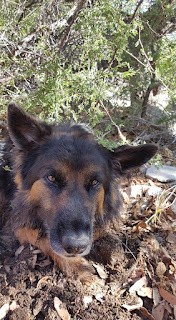
The full moon rise today was at 7:11pm. I scheduled a full moon hike with a few friends. SteveT and HollyW were able to make it. I picked up Holly at her house in town and then drove north another ten miles to pick up Steve. We were three humans and two dogs in one old Ford Escape. I let Steve drive to the trailhead in the state park.
The trailhead to the 4.2-mile Guindani Trail is at the end of the paved road in the Kartchner Caverns State park. Entrance to the park is $7 a car, $3.50 for Arizona veterans (which I am). We got to the gate at 5:40pm and no attendant was there, but self-serve envelopes were available. We parked in the most western parking lot where the trail begins.
The first mile of this trail around a hill is rather level, with a gentle uphill as it follows the Cottonwood Creek. It was dry today, and neither dog could find a watering hole. Luckily the sun was low enough not to bother us, but it was light enough to keep any predators away.
I hadn't been on this trail for three years. That second mile climbs steeply around the hill before it loops back around facing the west. It was a slow climb for us, but with clouds along the horizon, we were in no hurry to rush the hike because the rising moon was shrouded anyway. What we lacked in spectacular moon rise we more than made up for it with the sunset colors. We made it back around the hill just in time to see the Dragoons to the east light up in orange.
More later
Wednesday, June 27, 2018
Tuesday, June 26, 2018
The Gila
What a quiet night and morning it was. I woke up from sunlight. Where was everyone? Was I ready to hike the hotsprings? Sadie looked tired. I watched her move and decided that the 13-mile hike would be too much for her old body. I had to give her a break. Instead, I would hike the shorter route to the Middle Fork springs just a quarter-mile from the trailhead behind the visitor's center. Two cars were already parked there, telling me I'd have company.
The Middle Fork here winds through a floodplain that today was covered in sunflowers along the banks. No significant trees also meant much exposure, and it got hot fast this morning. I wanted to check out these hotsprings, measuring 109F, much hotter than the Jordan springs.
The trail descends quickly to the valley floor and follows the creek. The creek here is densely foliated with the tall sunflowers. But I quickly lost the trail. It suddenly stopped going uphill against a rock wall. Either the trail got covered by a recent rockslide, or I was to follow the stream. A rock cairn points to the hotsprings location, among tall reeds and some really muddy, steamy water.
Sadie put her front paws in the water and quickly pulled out. The edge of the river felt warm, not hot, but to her paws it surely doesn't feel normal. I was not about to take what surely would have been a steamy mudbath in the center of the springs. I simply turned around and walked back to the truck. We barely hiked over a mile. Now what?
The Gila Cliff Dwellings are just two miles north on the road and I wanted to explore the foot trail just north of the fee trail to the Cliff Dwellings. I had been to the Dwellings before and they are worth visiting, but dogs are not allowed and I didn't feel like paying $10. A uniformed volunteer brunette gal stood guard by the wooden footbridge over the Gila. When I asked her details about that trail, she couldn't say much other than that she and a few other employees got disoriented hiking there and ended up doing a big loop. Well, that is encouraging.
The Gila River trail promised to skirt the creek for several miles. I'd just do a few miles out, then back, and call it a day. This trail, however, quickly got away from the river and across an exposed meadow. The dogs enjoyed the two river crossings at the start, but the trail quickly got hot. Shortly after the first signed trail intersection, I concluded that this heat was not going to work well with me and the tired dogs and I turned around. The park volunteer was right: the trail here is poorly marked and confusing. I wanted a river walk, not a meadow walk.
I quickly came across a group of four men, a dad and his boys, who were looking for the TJ Corral trail. The trailhead for that is two miles south of the Cliff Dwellings, but I know there's also the marked trail that takes one into Bear Canyon. Again, it wasn't marked on the sign, and their park map didn't list that trail anywhere by name or number. I chatted with them for a bit and then wished them well, as they opted to hike uphill to Bear Meadow and camp out there somewhere.
Clouds were getting dark again. It looked like rain. We had hiked just under four miles on this trail and had had enough of heat and sun. Time to call it quits. I washed my hair at a water pump at a campsite across the road from the TJ Corral, and drove back toward Silver City.
I love this area, but it was time to leave. Two tired dogs, this constant heat and daily threats of storms were enough for me. I don't ever want to be caught in a flash flood in this valley. Thirty minutes into my return drive, it began to storm.
More later (I promise!)
Sunday, June 17, 2018
Slavin Gulch
The Slavin Gulch trail is in the western Dragoons, three miles north on FR 687 off Middlemarch Road north of Tombstone. This is a popular swimming hole for the locals.
_____
The morning started out rough. Sweetie had spent the night outside and was hugging the front door when I opened it for Bobby (who came in later). She had darted outside when the front door blew open in a strong wind while I was gardening in the backyard the afternoon before. Two hours later I watched Germany lose to Mexico 1-0 in its first World Cup 2018 match. Now I'll be rooting for whatever teams play Mexico. My World Cup season is already over.
The rain is now gone and the skies are clear again. Temperatures will slowly creep up back into the 90s, with no rain forecasted all week.

Ellen returned from her month-long assignment in eastern Virginia yesterday. We agreed to meet after her church service at noon. I invited HollyW and SusanM and she invited her mountainbiking friend Adam. We hiked the Gulch for 3.6 miles at a very leisurely 4.5 hours. The weekend's rain and the cloud cover made for a fun, mellow walk among friends.

I first met Adam two years ago when he joined Ellen and me on a two-peaker up Miller and Carr peaks. He drove down from eastern Tucson to meet us north of Tombstone.

The weather was milder and more cloudy than initially forecasted. A few days ago it predicted 90F and sunny. What we got instead was a pleasant 78F and cloudy, with a cool breeze. I took Zeke along and he stayed by my side the entire time. The rock-hopping probably tired him out some, as he took every rest break to his advantage.

Adam and Susan had never hiked up the Slavin Gulch trail and were in awe of the rock formations and water. I was impressed with the water level. So this is what three days of heavy rains result in! All three pools offered water three feet deep. Only Ellen went in all the way. I wasn't dressed for dunking and didn't even tell Holly or Susan to expect to get wet. I should have known that Ellen would want to get wet, DUH

The Slavin Gulch trail meanders uphill for four miles and ends at the Abril mine. The first mile is fairly level, with minimal ascent. The Gulch follows the trail the first two miles before disappearing in a tight canyon. The rocky uphill begins just past a rusty barbed-wire fence reduced to a foot in height. This is where the pools begin. During our dryer months, these pools disappear. The Dragoon mountains were now lush green from the rain.

We only hiked 1.8 miles before turning off the trail to the first slide. There wasn't much water here but I was surprised to discover this place. I've been to the three pools, but never this slide!

We walked back via the stream. This slowed us down and tired us out, as we had to do several chimney holds to get down the boulders. (That's when one uses one's arms to press against a narrow rock wall on either side). I had to take Zeke's ability into consideration and walk around large boulders or deep pools. Despite the warmth, he didn't want to get totally wet. We stopped at every pool along the way. We were in the Gulch for 4.5 hours! I had told Kevin I'd be gone for three hours (plus 45 minutes each way for the drive, oops)

I didn't bring snacks for Zeke and me. I'd left all that back in the truck. But Susan gave Zeke her leftover cheese sandwich. She now had a friend for life.

It's easier, faster and safer to just stay on the trail and drop down to each pool. Susan, Holly and I did that while Ellen and Adam, the two Spring chickens, stayed mostly along the creek. When we got to the lowest pool, and also my favorite because of its two waterfalls (both which were running today), I stayed behind in a shaded spot with Zeke. He was looking rather tired now.
People were going uphill as we were hiking back to our trucks. It was 6pm when we got back. I dropped Susan back at her Jeep in Tombstone, Ellen dropped Adam back at his car off SR80, and after dropping Holly back at her car parked outside Ellen's home, we two went out to Culver's for a relaxing meal. We were there for over an hour, talking about our extended families ("dysfunctional" being the key word here) and sharing parts of our childhood we hadn't done before. She gave me her leftover hamburger, which included some cold fries and lettuce, and Zeke ate it all before we reached the intersection with Buffalo Soldier Trail and SR92 four miles to the South. (He had more food once I got home)
"When I get older, I want a dog like Zeke!" said Ellen.
I got back home to a dark, quiet house. Kevin was already asleep. The dinner he had made, pasta with Italian sausage, was wrapped in the refrigerator. He sure had a lot of patience with me today, being gone much longer than told.
I know Steve would enjoy the Gulch with Trace, but he's getting ready for his roadtrip to Idaho and won't return until early December.
_____
The morning started out rough. Sweetie had spent the night outside and was hugging the front door when I opened it for Bobby (who came in later). She had darted outside when the front door blew open in a strong wind while I was gardening in the backyard the afternoon before. Two hours later I watched Germany lose to Mexico 1-0 in its first World Cup 2018 match. Now I'll be rooting for whatever teams play Mexico. My World Cup season is already over.
The rain is now gone and the skies are clear again. Temperatures will slowly creep up back into the 90s, with no rain forecasted all week.

Ellen returned from her month-long assignment in eastern Virginia yesterday. We agreed to meet after her church service at noon. I invited HollyW and SusanM and she invited her mountainbiking friend Adam. We hiked the Gulch for 3.6 miles at a very leisurely 4.5 hours. The weekend's rain and the cloud cover made for a fun, mellow walk among friends.

I first met Adam two years ago when he joined Ellen and me on a two-peaker up Miller and Carr peaks. He drove down from eastern Tucson to meet us north of Tombstone.

The weather was milder and more cloudy than initially forecasted. A few days ago it predicted 90F and sunny. What we got instead was a pleasant 78F and cloudy, with a cool breeze. I took Zeke along and he stayed by my side the entire time. The rock-hopping probably tired him out some, as he took every rest break to his advantage.

Adam and Susan had never hiked up the Slavin Gulch trail and were in awe of the rock formations and water. I was impressed with the water level. So this is what three days of heavy rains result in! All three pools offered water three feet deep. Only Ellen went in all the way. I wasn't dressed for dunking and didn't even tell Holly or Susan to expect to get wet. I should have known that Ellen would want to get wet, DUH

The Slavin Gulch trail meanders uphill for four miles and ends at the Abril mine. The first mile is fairly level, with minimal ascent. The Gulch follows the trail the first two miles before disappearing in a tight canyon. The rocky uphill begins just past a rusty barbed-wire fence reduced to a foot in height. This is where the pools begin. During our dryer months, these pools disappear. The Dragoon mountains were now lush green from the rain.

We only hiked 1.8 miles before turning off the trail to the first slide. There wasn't much water here but I was surprised to discover this place. I've been to the three pools, but never this slide!

We walked back via the stream. This slowed us down and tired us out, as we had to do several chimney holds to get down the boulders. (That's when one uses one's arms to press against a narrow rock wall on either side). I had to take Zeke's ability into consideration and walk around large boulders or deep pools. Despite the warmth, he didn't want to get totally wet. We stopped at every pool along the way. We were in the Gulch for 4.5 hours! I had told Kevin I'd be gone for three hours (plus 45 minutes each way for the drive, oops)

I didn't bring snacks for Zeke and me. I'd left all that back in the truck. But Susan gave Zeke her leftover cheese sandwich. She now had a friend for life.

It's easier, faster and safer to just stay on the trail and drop down to each pool. Susan, Holly and I did that while Ellen and Adam, the two Spring chickens, stayed mostly along the creek. When we got to the lowest pool, and also my favorite because of its two waterfalls (both which were running today), I stayed behind in a shaded spot with Zeke. He was looking rather tired now.

People were going uphill as we were hiking back to our trucks. It was 6pm when we got back. I dropped Susan back at her Jeep in Tombstone, Ellen dropped Adam back at his car off SR80, and after dropping Holly back at her car parked outside Ellen's home, we two went out to Culver's for a relaxing meal. We were there for over an hour, talking about our extended families ("dysfunctional" being the key word here) and sharing parts of our childhood we hadn't done before. She gave me her leftover hamburger, which included some cold fries and lettuce, and Zeke ate it all before we reached the intersection with Buffalo Soldier Trail and SR92 four miles to the South. (He had more food once I got home)
"When I get older, I want a dog like Zeke!" said Ellen.
I got back home to a dark, quiet house. Kevin was already asleep. The dinner he had made, pasta with Italian sausage, was wrapped in the refrigerator. He sure had a lot of patience with me today, being gone much longer than told.
I know Steve would enjoy the Gulch with Trace, but he's getting ready for his roadtrip to Idaho and won't return until early December.
Saturday, June 16, 2018
Tropical Storm Bud Light
We never got the overnight thunderstorms I was so looking forward to. Perhaps TS Bud hit other areas more intently. What we got along the border was a constant drizzle that soaked the top soil. Hurricane Bud strolled through as a tropical storm Bud Light. Today's high was a cool 71F.

I took the pack out for a nice, long 4.4-mile walk around Ranchos San Pedro, using both dirt and paved roads. A lone cyclist took advantage of the early morning tranquility and pedaled along the little-used roads. Another walker nearby worked on his stride. I kept away from civility and let the dogs run unimpeded. I like getting good mileage in with these dogs as they tire out and don't bug me for another walk later on.

Heavy clouds lingered over the mountains. I couldn't see San Jose peak in Sonora. Ramsey and Carr canyons were covered in a low, drifting fog. I saw many more red mites today, more immigrant trash hidden in a ditch along a quiet intersection (the intersection I never see USBP lie in wait), and more beer cans and bottles. I always make it a habit to clean up what I can, without making my walk weighed down by the bottles or cans.

The two young coyotes that entertained us last fall are gone, surely killed by the fire. I miss their yips. But we did come across two ground holes that are big enough for a coyote den. The dogs sniffed that but didn't dig in. Sweety found what I think is a desert rat den and insisted on digging in. She stuck her head in deep but luckily nothing came out except for her sandy head.

Minnie, as usual, struggled with the distance but I slowed down to her pace. There were plenty of puddles to drink out of. Both Sweetie and Sadie's butt fur was coming loose from all the walking. Better outside than in the house!

Humidity was high and I felt it on my clothes. I got home smelling of a wet desert, a scent of creosote, charcoal and wet sand. This time I didn't bring home a swarm of insects.
It cleared up in the early afternoon for a few hours. Big, white cumulus clouds dotted the sky before a second mass of wind and drizzle blew in in the late afternoon.
World Cup 2018 started yesterday. Spain and Portugal tied with 3, France beat Australia 2-0. I watched most of the Denmark-Peru match when I got back from my walk. That Danish goalkeeper Kasper Schmeichel is something else! Watching him intercept attempted goals made me stare at the computer screen in total disbelief. It was even more disbelieving when I realized I am now old enough to be his mom!
The big game I'm looking forward to is Sunday's match of Germany and Mexico.

I took the pack out for a nice, long 4.4-mile walk around Ranchos San Pedro, using both dirt and paved roads. A lone cyclist took advantage of the early morning tranquility and pedaled along the little-used roads. Another walker nearby worked on his stride. I kept away from civility and let the dogs run unimpeded. I like getting good mileage in with these dogs as they tire out and don't bug me for another walk later on.

Heavy clouds lingered over the mountains. I couldn't see San Jose peak in Sonora. Ramsey and Carr canyons were covered in a low, drifting fog. I saw many more red mites today, more immigrant trash hidden in a ditch along a quiet intersection (the intersection I never see USBP lie in wait), and more beer cans and bottles. I always make it a habit to clean up what I can, without making my walk weighed down by the bottles or cans.

The two young coyotes that entertained us last fall are gone, surely killed by the fire. I miss their yips. But we did come across two ground holes that are big enough for a coyote den. The dogs sniffed that but didn't dig in. Sweety found what I think is a desert rat den and insisted on digging in. She stuck her head in deep but luckily nothing came out except for her sandy head.

Minnie, as usual, struggled with the distance but I slowed down to her pace. There were plenty of puddles to drink out of. Both Sweetie and Sadie's butt fur was coming loose from all the walking. Better outside than in the house!

It cleared up in the early afternoon for a few hours. Big, white cumulus clouds dotted the sky before a second mass of wind and drizzle blew in in the late afternoon.
World Cup 2018 started yesterday. Spain and Portugal tied with 3, France beat Australia 2-0. I watched most of the Denmark-Peru match when I got back from my walk. That Danish goalkeeper Kasper Schmeichel is something else! Watching him intercept attempted goals made me stare at the computer screen in total disbelief. It was even more disbelieving when I realized I am now old enough to be his mom!
The big game I'm looking forward to is Sunday's match of Germany and Mexico.
Friday, June 15, 2018
After the rain

I waited until Kevin left for work to take the dogs out for their walk. The sky was overcast and the increased humidity was noticeable. The dogs didn't care about that. They were just happy to get their exercise in.
It was 5:50am when I parked the truck and headed east on the dirt road. The first NFS employee drove in and a USBP employee drove out. The sky to the south still looked like more rain is coming later.

The smell of charcoal was already less prevalent today. With enough downpours, the black ash that is coating the ground will wash away, and the standard desert brown will return. Slowly the herbaceous plants are growing back. There are plants that grow here that I don't see in the mountains. I want to learn to identify them all.

I followed the firetruck road for the 2.6 miles. I walked at a slow pace, as I had no time records to break this morning. The first thing I noticed as a result of yesterday's rain is the presence of the red velvet mite. I saw at least five crawling on the ground and some were rather large. Those mites like to feast on birds, but can also do serious damage to mammals.

It was quiet except for the birds. Morning doves like to perch on the burned mesquite trees. Ravens like to hold sentry in taller trees and squawk at intruders. In my case, the dogs and I were the intruders and the ravens were having nothing of that! What can the birds do to scare us off, besides fly overhead and shit on us? The dogs were oblivious. They were more interested in all the scents on the ground, made stronger by the moisture. They only want me around so that I can drive them back home where the food is.

I was all alone this morning in this hidden trail. A USBP helicopter flew nearby but stayed along the foothills, then flew back into town. We don't see those helicopters fly over like we once did when we moved here in late 2004, when hearing the sound of the rotors was a weekly occurence. I prefer this more tranquil state, although this area still shows remnants of smugglers: discarded and now rusty or burned tin cans, muddy glass jars are strewn across the area.
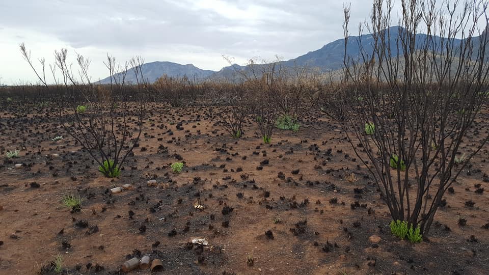
This 300 acre parcel of land that burned in late April is slowly regrowing. While it will take months for the black ash to wash away, I see new plants every time I walk through here (about four times a week). The dead prickly pear I thought was gone a month ago is now showing healthy new pads. More wildflowers are now open to be admired.

The diffused light made by the heavy cloud cover gave today's walk a clearer view for photographs, avoiding shadows that would normally be distracting.
I heard birds, I heard distant barking of neighborhood dogs, I heard the traffic on SR92. And yet there I was, completing my 2.6-mile loop in peace. I took a lot of photographs and came home to four panting dogs and a shirt full of flying insects: I had mistakenly walked right into a swarm of flying insects as I approached my truck. Bugs and mites, the bane of the monsoon season, but hell, the forest and wildlife nead this water.

Thursday, June 14, 2018
Carr Peak with Bill, Sadie and Zeke
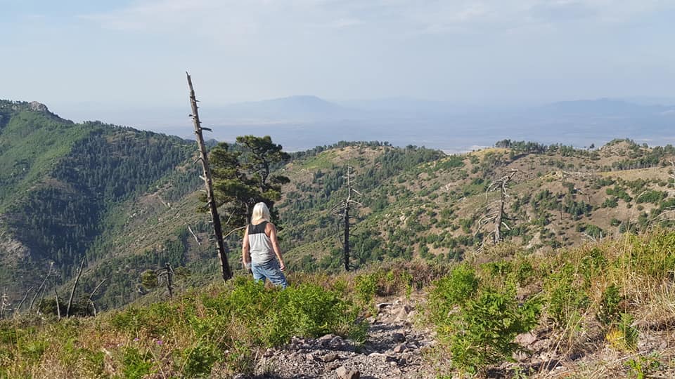
I did not hike up Carr Peak for May due to the drought. I was not expecting any new growth after two months of no rain. The April hike proved rather dull for flora. But I knew that I needed to hike up the peak for June. I expected today's hike to be no different. I wanted to hike up to the peak just to have "before" and "after" photographs with the incoming rain due tomorrow.
Both Bill and I were pleasantly surprised. He joined me at the last minute, as he wasn't initially excited about hiking up a hot, dry peak. I almost cancelled the hike because the predicted high today was 97F and I didn't want to hike in the heat. Granted, it's always ten degrees cooler on top, as well as cooler in the morning, but the lack of any forecasted clouds had me a bit concerned. Was this going to be more of a chore, rather than a hike? I could always do this hike next week when cooler temperatures are forecasted.
We met at 5am in the Perimeter parking area. We drove together in my truck, with both Sadie and Zeke excited about the hike. Do these dogs really enjoy hiking as much as I do?
We stopped a mile up the road to watch the sunrise. The cloud cover added to the color scheme, and there were reds that I don't normally see at sunrise. We watched the colors for a good 20 minutes.
 This view had us both invigorated. One thing about hiking with Bill is that he enjoys these acts of nature. He can easily post 220 photos after a hike, showing flowers, mushrooms, birds, grass blades, insects, all with the enthusiasm of a small child. Who gets up to watch a sunrise? He appreciates the little things in life.
We made it to the Sawmill trailhead by 5:40am. No one else was parked there. It was 6am when we got to the intersection with the Carr Peak trail. The sun was now behind clouds and it was a cool, pleasant hiking for the first half of this hike before the clouds disappeared and we faced clear skies.
 I felt good. I didn't have to stop once to gather my breath. Perhaps all those power hikes that Bill and I do are paying off! Even when the sun came out, we marched on forward.
 The biggest surprise for us both was the wildflowers. They appeared a few at a time at first, and I told Bill I was going to photograph every species we come across. By the end of the hike, we had spotted close to 20 different flowers, from sunflowers to blue salvias, Red Cardinals, verbena, firecracker penstemons. There were many others I couldn't quickly identify. I also noted that the vista from the peak in all directions was greener than it was in April. It didn't take much rain after all!

Bill wouldn't believe me when I told him that this 5.7-mile hike takes about 3.5 hours, including breaks. "No way!" he said. By the time we got to the peak, he realized that I was correct. He didn't take into consideration the many stops we made to photograph the flowers, or to stop and watch the birds (woodpeckers, titmouse, ravens, even a Western bluebird!) The birds were more vocal when the sun was behind the clouds. They quieted down when the sun came out in full blast.


Both Bill and I were pleasantly surprised. He joined me at the last minute, as he wasn't initially excited about hiking up a hot, dry peak. I almost cancelled the hike because the predicted high today was 97F and I didn't want to hike in the heat. Granted, it's always ten degrees cooler on top, as well as cooler in the morning, but the lack of any forecasted clouds had me a bit concerned. Was this going to be more of a chore, rather than a hike? I could always do this hike next week when cooler temperatures are forecasted.
We met at 5am in the Perimeter parking area. We drove together in my truck, with both Sadie and Zeke excited about the hike. Do these dogs really enjoy hiking as much as I do?
We stopped a mile up the road to watch the sunrise. The cloud cover added to the color scheme, and there were reds that I don't normally see at sunrise. We watched the colors for a good 20 minutes.

We made it to the Sawmill trailhead by 5:40am. No one else was parked there. It was 6am when we got to the intersection with the Carr Peak trail. The sun was now behind clouds and it was a cool, pleasant hiking for the first half of this hike before the clouds disappeared and we faced clear skies.


Bill wouldn't believe me when I told him that this 5.7-mile hike takes about 3.5 hours, including breaks. "No way!" he said. By the time we got to the peak, he realized that I was correct. He didn't take into consideration the many stops we made to photograph the flowers, or to stop and watch the birds (woodpeckers, titmouse, ravens, even a Western bluebird!) The birds were more vocal when the sun was behind the clouds. They quieted down when the sun came out in full blast.

We didn't come across anyone else until we were a mile from the finish. We had all this splendor to ourselves! I brought plenty of water for the dogs as there was none along the way. Both took it all in stride. If they needed a shade break, I stopped to give it to them.
The landscape's flora has changed since the 2011 fire (which was burning seven years ago this week, ugh). Firecracker penstemon dotted the hillsides then. Now we have various species of sunflowers. A few penstemon and salvias are evident higher up.

The last 100 feet, so above 9000' is where I see different flowers. This is the alpine region with its unique habitat of exposed wind and frost. We spotted four different flowers here.


We didn't stay at the peak for long. The dogs rested in the shade of the manzanitas and had their water. Bill and I took more photos. I spotted one ladybug. (Ladybugs gather on our high peaks in late July to mate, so this one came early) And then we went back down the way we came. My phone warned me that I only had 15% charge left, which surprised me since I started this hike with it fully charged. Luckily I had two phones to track the GPS.

We met a group of eight hikers going uphill as we were almost done. We were back at the cars in 3:35 hours, both feeling excited about having done this. Now I want to come back up here in a week to see of any changes (new growth) after this weekend's rain.
We saw the Thursday Carr Canyon Road walkers as we drove down to our parking lot. The dogs were barking loudly so I didn't stop to ask them if they were going out to eat after the walk. I dropped Bill off at his truck, then drove back up to talk to Steve and Rick, who were both still walking the course. Rick wasn't eating afterward, but both Steves were interested.
And this is how I ended up spending two more hours eating lunch. We ate at Taco Giro in town and didn't leave there until past noon. No wonder I never get enough done at home!

Two hours later the house got dark. I was in the guest bedroom writing an Amazon review when I noticed the lack of light. We normally have the full afternoon sun against our southern walls. That was from the dark clouds moving overhead. Oh my, the big storm forecasted for tomorrow came a day early!

And then it began to rain. And rain hard. The wind kicked in, it thundered. This is all from Hurricane (now a Tropical Storm) Bud (now Bud Lite, ha!) swirling up the eastern Pacific. Minnie went into hiding and the rest of the dogs lay in the bedroom. It was still raining when Kevin came home. Small pools of water gathered in the backyard.
When the rain stopped at 6:30pm, I once again ended the way I started today: with a refreshing walk and a colorful sun. I hiked over nine miles today and it didn't even feel exhausted.


Wednesday, June 13, 2018
Charleston Ghost Town
Hike: 3.2 miles
Elevation: 3992' -4026'
Significance: adobe ruins, old stampmill
Trail head access: east side of San Pedro River, 1/4 mile from bridge on Charleston Road.
Follow San Pedro River trail north until you reach wash, then turn west on wash to river. Cross river and look for adobe ruins.
 Steve had mentioned that he had wanted to explore the Charleston ghost town. He is a degreed geologist and is interested in Old West history.
Charleston was once a bustling mill town for Tombstone ten miles away, but the town quickly died when the mines in Tombstone flooded and closed down. By 1899 there was nothing left of the town as everyone had left to seek their fortune elsewhere. All that is left now are stone walls of the mill, and adobe ruins of Charleston, hidden by mature mesquite across the river on the opposite bank.
Elevation: 3992' -4026'
Significance: adobe ruins, old stampmill
Trail head access: east side of San Pedro River, 1/4 mile from bridge on Charleston Road.
Follow San Pedro River trail north until you reach wash, then turn west on wash to river. Cross river and look for adobe ruins.

Charleston was once a bustling mill town for Tombstone ten miles away, but the town quickly died when the mines in Tombstone flooded and closed down. By 1899 there was nothing left of the town as everyone had left to seek their fortune elsewhere. All that is left now are stone walls of the mill, and adobe ruins of Charleston, hidden by mature mesquite across the river on the opposite bank.
It's not easy to find the ruins. The secret is finding a safe path to get to these ruins, as there are no signs and no designated trail to get there. The land is under the care of the Bureau of Land Management. There is no fee to hike here.

Wednesday looked like a good day and we agreed to get together early for this hike. I hadn't been back there in almost a decade; it was time I walked through there again. I brought Zeke and Minnie on this hike. The river alone is a nice place for both man and dog. I've taken many solitary walks north along the river bank with Sammy and Sara years ago.

We met at 6am by the Fry's Foods in town and drove separately to the marked Millville parking area nine miles away, on the east side of the San Pedro River. It was still cool and overcast as we began our hike north on the San Pedro River trail before cutting sharply to the west via a wash. This wash took us to a popular railroad overpass that is now heavily spray-painted. We have to go through the tunnel
to get to the river which we had to cross to get to the Charleston ruins. The tunnel makes for a cool, refreshing rest break on hot days. The "art" always changes here.


The river was low here and we were able to ford across effortlessly. The river here during the monsoon can get high, so coming here before the forecasted rain this weekend was a good idea. The old ruins of Charleston are on the western banks of the river, but there are no signs indicating where to go. People interested in exploring Charleston will have to do some online research. We followed what looked like a game trail up the bluff. We had to climb up a steep grade to the western side. We quickly found the first adobe ruins.


The dogs had fun chasing each other. Zeke stayed with me, but Minnie and Trace seemed to be interested in each other. Trace has the energy of a young dog, and Minnie can't keep up with him, but she enjoyed running around and sniffing the area. We even came across an old toilet! Was this wooden bench really from the late 19th century?

The remaining ruins are now hidden by mature mesquites. It's hard to get a feel for how the homes were once laid out as one no longer has clear view of where the main streets were. Mesquites are fast growers and have strong, deep taproots. The trees weren't here when the town was active. None of the ruins is marked with the name of the original owner. We could see walls, door entrances and perhaps window openings. These adobe walls are slowly disappearing with each summer rain. Small depressions between several of the ruins were perhaps used for cold storage.

There is a wide path here among the ruins, which Steve thinks was once Main Street. Most of the homes for lower-income people were made of wood, and those structures are long gone.
I had no map of the old town and perhaps should have procured one to better help Steve get an idea of how big of an area the town once held. We walked the path northward but the path quickly ended and a smaller trail led into a small drainage or wash of rocks. Perhaps this was the old dumping area. One rock looked like it had petroglyphs on it.
I would need to do some homework. I'd like to come back here and do a more thorough study of the area.

We circled back to the river, the dogs had more fun there, and then we went back to the wide wash and walked toward the ruins of Millville, where the people in Charleston worked. This part of the area is well-marked. The trail branches out toward the old stampmill/petroglyphs and the main San Pedro trail meanders around the Charleston hills and continues north along the river. We concentrated on the ruins.

It was now warming up. While Trace has no difficulties in this heat, Minnie easily pants. I had the dogs rest under a bench (one of three provided by the BLM) while Steve read the informational plaques describing the old mill, the town, and the important residents at the time. It was getting warm now and we had no shade.
I took Steve to the high point of the old mill, from where one can see how the area was once laid out. The river's bed here surely has changed its path over the years. It's now wide here and covered with cottonwoods and ash, both which were not here during the town's heyday. The view southeast expands toward the Huachuca mountains, with the green canopy of the cottonwoods along the river marking the location of water.
Years ago Kevin and I walked around the hillside here, but even then we had to contend with the prickly shrubbery along the way: catclaw acacia being a big nuisance for anyone contemplating bushwacking around. Steve opted not to go any higher. We had lost any cloud cover now. We could see tailings down below but we ignored all that, walking back the way we came back to our cars. We had walked 3.2 miles in the 2.5 hours. It was now getting quite warm. There is more to see and discover at these ruins, but we'll save that for another day.
I suggested we eat at MyPlace in town, the popular diner for budget-minded people. I like this place! During the week the restaurant has $3.99 breakfast deals until 10am. It was 9:20am when we arrived, seated by a window table in the conference room on the west side, so that we could see the cars outside in case the dogs got restless. We both ordered the #8 special: a biscuit topped with sausage gravy, two eggs, and a sausage patty. We drank water to rehydrate. We sat in a side room, where every second Wednesday of the month the Women's Council of Realtors has its monthly meeting.
I got home after noon and here is when I realized I had gotten dehydrated. I was tired, low on energy. I didn't have the strength to go over my photographs and blog about our little exploratory hike. I ended up falling asleep early in the evening, totally forgetting about walking Sweetie and Sadie another mile to complete my daily four-mile quota. I only made it to 3.4 miles.
e

Wednesday looked like a good day and we agreed to get together early for this hike. I hadn't been back there in almost a decade; it was time I walked through there again. I brought Zeke and Minnie on this hike. The river alone is a nice place for both man and dog. I've taken many solitary walks north along the river bank with Sammy and Sara years ago.

We met at 6am by the Fry's Foods in town and drove separately to the marked Millville parking area nine miles away, on the east side of the San Pedro River. It was still cool and overcast as we began our hike north on the San Pedro River trail before cutting sharply to the west via a wash. This wash took us to a popular railroad overpass that is now heavily spray-painted. We have to go through the tunnel
to get to the river which we had to cross to get to the Charleston ruins. The tunnel makes for a cool, refreshing rest break on hot days. The "art" always changes here.


The dogs had fun chasing each other. Zeke stayed with me, but Minnie and Trace seemed to be interested in each other. Trace has the energy of a young dog, and Minnie can't keep up with him, but she enjoyed running around and sniffing the area. We even came across an old toilet! Was this wooden bench really from the late 19th century?

The remaining ruins are now hidden by mature mesquites. It's hard to get a feel for how the homes were once laid out as one no longer has clear view of where the main streets were. Mesquites are fast growers and have strong, deep taproots. The trees weren't here when the town was active. None of the ruins is marked with the name of the original owner. We could see walls, door entrances and perhaps window openings. These adobe walls are slowly disappearing with each summer rain. Small depressions between several of the ruins were perhaps used for cold storage.

There is a wide path here among the ruins, which Steve thinks was once Main Street. Most of the homes for lower-income people were made of wood, and those structures are long gone.
I had no map of the old town and perhaps should have procured one to better help Steve get an idea of how big of an area the town once held. We walked the path northward but the path quickly ended and a smaller trail led into a small drainage or wash of rocks. Perhaps this was the old dumping area. One rock looked like it had petroglyphs on it.
I would need to do some homework. I'd like to come back here and do a more thorough study of the area.

We circled back to the river, the dogs had more fun there, and then we went back to the wide wash and walked toward the ruins of Millville, where the people in Charleston worked. This part of the area is well-marked. The trail branches out toward the old stampmill/petroglyphs and the main San Pedro trail meanders around the Charleston hills and continues north along the river. We concentrated on the ruins.

It was now warming up. While Trace has no difficulties in this heat, Minnie easily pants. I had the dogs rest under a bench (one of three provided by the BLM) while Steve read the informational plaques describing the old mill, the town, and the important residents at the time. It was getting warm now and we had no shade.
I took Steve to the high point of the old mill, from where one can see how the area was once laid out. The river's bed here surely has changed its path over the years. It's now wide here and covered with cottonwoods and ash, both which were not here during the town's heyday. The view southeast expands toward the Huachuca mountains, with the green canopy of the cottonwoods along the river marking the location of water.
Years ago Kevin and I walked around the hillside here, but even then we had to contend with the prickly shrubbery along the way: catclaw acacia being a big nuisance for anyone contemplating bushwacking around. Steve opted not to go any higher. We had lost any cloud cover now. We could see tailings down below but we ignored all that, walking back the way we came back to our cars. We had walked 3.2 miles in the 2.5 hours. It was now getting quite warm. There is more to see and discover at these ruins, but we'll save that for another day.
I suggested we eat at MyPlace in town, the popular diner for budget-minded people. I like this place! During the week the restaurant has $3.99 breakfast deals until 10am. It was 9:20am when we arrived, seated by a window table in the conference room on the west side, so that we could see the cars outside in case the dogs got restless. We both ordered the #8 special: a biscuit topped with sausage gravy, two eggs, and a sausage patty. We drank water to rehydrate. We sat in a side room, where every second Wednesday of the month the Women's Council of Realtors has its monthly meeting.
I got home after noon and here is when I realized I had gotten dehydrated. I was tired, low on energy. I didn't have the strength to go over my photographs and blog about our little exploratory hike. I ended up falling asleep early in the evening, totally forgetting about walking Sweetie and Sadie another mile to complete my daily four-mile quota. I only made it to 3.4 miles.
e
Friday, June 8, 2018
Our first rain!
The morning started out simple enough. Steve came over to replace Kevin's front rotors and brake pads on his Honda Ridgeline and afterward we all had a late breakfast at the Country Kitchen. I was still exhausted from the lack of good sleep the night before and just tried to nap in the early afternoon. But then that bright sky slowly became overcast and by 2pm I thought I had heard thunder.
I went out into the backyard and saw dark clouds over the mountains. I also saw dry lightning. Excited about this unexpected weather (the forecast had no rain predicted, and humidity was at 13%) I grabbed my phone and climbed up on the roof to watch the mountains better. I hadn't been up there in a while.

Our palm tree swayed, birds chirped in the Italian pine tree next to our house and neighborhood dogs barked. This weather clearly got the wildlife excited. It even began to drizzle some. The foothills of Brown Canyon looked like they were even getting some rain.

Bill and I had planned on walking the Brown Canyon loop trail again, but I opted to cancel it. There's always more rain in the foothills than in the valley. Bill agreed.

It was still raining at 6pm. The dogs were restless so I decided to take them out to the burn area for a walk. If the rain got worse, I'd just turn around. Getting a little wet wouldn't bother me. It rained hard on my drive to the starting point, but then it subsided to a low drizzle. It drizzled for 40 minutes before the rain stopped entirely and the remaining minutes of sunlight resulted in a bright double rainbow before sunset.

Burned charcoal dominated the scents while in the burn area. But then that gave way to wet creosote. There were a few puddles along the path.
This was such an invigorating walk! I'm so looking forward to the monsoon season. We are predicted to have a wetter-than-normal season this year. Bring it on!
 I saw distant lightning to the south as I drove back home with four very happy dogs.
I went out into the backyard and saw dark clouds over the mountains. I also saw dry lightning. Excited about this unexpected weather (the forecast had no rain predicted, and humidity was at 13%) I grabbed my phone and climbed up on the roof to watch the mountains better. I hadn't been up there in a while.

Our palm tree swayed, birds chirped in the Italian pine tree next to our house and neighborhood dogs barked. This weather clearly got the wildlife excited. It even began to drizzle some. The foothills of Brown Canyon looked like they were even getting some rain.

Bill and I had planned on walking the Brown Canyon loop trail again, but I opted to cancel it. There's always more rain in the foothills than in the valley. Bill agreed.

It was still raining at 6pm. The dogs were restless so I decided to take them out to the burn area for a walk. If the rain got worse, I'd just turn around. Getting a little wet wouldn't bother me. It rained hard on my drive to the starting point, but then it subsided to a low drizzle. It drizzled for 40 minutes before the rain stopped entirely and the remaining minutes of sunlight resulted in a bright double rainbow before sunset.

Burned charcoal dominated the scents while in the burn area. But then that gave way to wet creosote. There were a few puddles along the path.
This was such an invigorating walk! I'm so looking forward to the monsoon season. We are predicted to have a wetter-than-normal season this year. Bring it on!

Subscribe to:
Posts (Atom)