Saturday, March 30, 2019

Bug Springs trail, Catalina Mtns north of Tucson

This was my big hike with the Huachuca Hiking Club.  A total of seven hikers showed up: SteveA, SteveS, Mel, Barry, Kent and Rod and I drove in two cars to the lower Bug Springs parking lot.  The lot was crowded with mountain bikers.  We had to make way for 13 more on our way up to the high point.  Some of those were coming down the trail like bats out of hell.  A few were pushing their bikes through the steep and rocky sections near the high point.

It was perfect weather for today's hike, even though Tucson's weather was forecasted to be "clear and 80F."  It was 56F according to my Honda when we started, and a constant cool breeze kept us cool.  High wind-swept cirrus clouds also diffused the sun.

The only disappointment was the lack of a wildflower boom.  There were plenty of brittlebush flowers as we drove up the Catalina Highway, but none on the trail.  We saw instead small clusters of purple flowers such as verbena.  I also spotted yellow monkeyflowers and a white cluster flower.


The Bug Springs trail is in a transitional zone.  You start at 4950" in a high desert with agaves and yuccas and finish at 6275' near Green mountain among the pine.  Along the  you have expansive views toward Tucson and the south and southeast, and as you get near the high point, even Mount Wrightson appears.  At the high point one can even see the Catalina Highway switchback up the mountain.


We started out strong.  Kent and SteveS quickly bypassed everyone and then had to wait 40 minutes for the rest of us. I came in fourth (but who's counting?).  I was just happy to have plenty of water for Zeke.  Cherry Creek was running nicely and the trail follows the creek for .8 miles before the trail juts back uphill for the finish.  The shaded creek, hoodoos, and vistas make this an allround challenging hike.  The decomposed granite surface in the higher elevation made for a few slick slides.  I was still wearing my New Balance sneakers from last week's California road trip.


The post hike meal today was at the Saguaro Corner restaurant, a spacious restaurant near the Saguaro National Park.  It offers 20 craft beers on tap, many which were IPAs.  I had two Glendale, CA Golden Road mango cart (4% ABV, 10 IBU) beers, which, according to the brewery's website, is a "light wheat ale bursting with lots of fresh mango flavor finishing crisp and refreshing" although neither Kent nor I thought the beer was very mango-y.  The low alcohol did make the beer refreshing and it went well with my chicken tacos.  While the conversation during the meal covered all the usual topics including Canada, Trump, and upcoming club hikes, we all wondered what "Bier de Garde" (strong French pale ale) or"Wee Heavy" (rich, malty Scottish ale) beer styles are.  So much for being beer snobs.


Thursday, March 28, 2019

Mattie the Maltipoo

No one ever came forward to claim the little dog.  All I got was two email from a traveling nurse in Salinas, CA who wrote me saying she has been traveling in the King City, CA area for ten years and in those ten years she has found six small white dogs no one ever claimed.  She ended up paying out of pocket to have the dogs medically vetted, spayed/neutered and adopted out, mostly to her own patients.  I'm sure the dog was just one more statistic to the abandoned animal count in California.

I named the matted dog Mattie.  She stayed in the guest bathroom during her stay, but I knew that was not ideal.  She needed space to run around, and she needed human contact.  The only contact she got from me was when I visited her, usually twice a day while brushing my teeth and other personal hygiene tasks.  I promised Kevin I would take her to the closest vet when I wasn't working, to have her checked for a chip.

It had been a hot four days back in Arizona.  I went from temperatures in the 60s to temperatures in the 80s.  I'm sure for the dog that was no fun, but at least the bathroom is on the north side of the house.  I bathed her a second time in the sink when I got home, then took her bundled in a towel to the Coronado Animal clinic off Glenn Street in Sierra Vista.  It just so happens that one of the vet techs there founded Rescue Adopt Volunteers (RAV), a small dog rescue.  She gets donations from the public.  She volunteered to take Mattie and promised to keep me up-to-date on her progress.  I gave her a generous donation, enough to cover her spay surgery.


Mattie is an affectionate, emotive little dog.  I can see why elderly people like the breed so much.

Sunday, March 24, 2019

Day Ten: Yuma's Telegraph Hill, and coming home

I missed my sunrise wake-up.  It was already past 7am.  The hike for today was walking up Telegraph Hill east of Yuma off a frontage road.  I saw the trail description on my Alltrails app, perhaps the most useful app I use when I travel because it references local trails in the area I'm in.  The trail was described as 5.5 miles long and strenuous.  I had to check it out.

The Telegraph Hill pass is just outside Yuma on the east.  I-8 meanders through this rocky pass as it snakes east-west.  Dry brown hills are on either side.  It's a very popular hike for Yumans, as I discovered, because at 8:30am more people were coming back from the hike when I was just starting.  The large parking lot was rather full.  Oh boy.  Would Mattie be ok in the car alone, with the windows open?

I parked the Honda against the rising sun.  I didn't think she would be able to jump out.  She was in the shade.  The morning air was cool and there was a refreshing breeze.  That breeze kept me cool on this hike as well.

I followed the crowd.  There are no trail markers here but the trail is obvious.  The first mile is a singletrack through low foothills, before the trail merges with a paved maintenance road at the 1.4-mile mark at the gate.  From the gate up it's very steep for that final mile.  Shade still cooled the route, but that shade was gone on the return hike.

People of all ages were doing this hike, from white-haired retirees to young families and uniformed Marines in full battle rattle.  I had to stop briefly a few times to catch my breath, but I was enjoying the physical challenge.  This may be a paved road but it kicks your butt!  There was a poster on the gate warning hikers of a Crocodile Monitor Lizard in the area, a lizard that was most likely once a pet and then released when it got too big.  There was no date on that poster.

For the first time all week, I took my sweater off.  It was 66F when I started the hike.


Most people just make it to the first radio tower.  Even here one can see the green agricultural fields outside Yuma, the endless rows of white RVs along the Colorado River, and the small homes of the field workers on the south side.   The hills here resemble piles of brown rocks.  I remember describing these as "god's dumping ground" when Tim and I first drove through here in 1986 on our way to Fort Huachuca with six-month-old baby Erin.  I'm now finally exploring these rocks!


The morning haze dampened the colors.  Arizona was clearly dryer than California, but there was an aroma here I didn't smell in California: the smell of damp creosote.  The creosote was already blooming.

I walked to the farthest radio tower, adding .8 miles r/t to the mileage.  It was a 5.5-mile hike I'm so glad I did!  I will do this hike again when in the area.

Little Mattie was napping when we got back to the Honda.  She jumped with joy at hearing my voice, the side window now even more snotty than before.  There were fewer cars now in the lot, but people were still starting the hike as the temperature slowly creeped up.  I sat in the Honda with the windows open, feeling quite comfortable since we were still in the shade.   It was now time to finish the drive.  I was ready.
***

There is nothing in Arizona for 90 miles as one travels east of Yuma on I-8.  All one sees are low, treeless hills with saguaros, cholla and creosote. Gila Bend is the first big town along the way, with a few restaurants and fast food joints.  To the south is the Organ Pipe National Park, a place I've yet to see, and a popular smuggling route for drug runners.  I normally just drive across this region, focused on my destination.  I didn't stop for a date shake.  I drove quietly while listening to the analysis of the Mueller Report which was released on Friday, and continuing news of the Christchurch mosque killings in New Zealand the Friday before.  Both topics were non-stop on all the news channels I listen to.  Even I got tired of the same old rhetoric.  It was time to shut that off and switch to classic rock while I reminisced about the great week that I had traveling through California, spending time with an old friend, and seeing my son Eric again. 

Wildflowers finally appeared as I neared Casa Grande.  I turned off I-8 and went south via I-10.  Now I saw more flowers, even poppies.  My one stop was at the Catalina Brewing Company, a small brewery off Ina Road, but due to construction off I-10 hard to get to.

I walked in and was greeted by New Jersey Gal Maria.  "Hi, are you a mountain biker?"  Did I look like a mountain biker, I thought, but then realized that mountain biking is this brewery's theme.  Anyone who comes in dressed like a mountain biker gets a 10% discount.  I certainly didn't look like a mountain biker.  I looked more like someone who had slept in her car with two dogs and who had sweated up a storm hiking a dry hill.  I hadn't even combed my hair yet.

I got the 10% military discount instead.  I can't complain!  And the wheat beers I tried were both very good. I stayed long enough to chat with Maria, saw mountain bikers come in with their colorful jerseys and helmets, thanked her and promised to come back, and resumed my drive home.  It was mid afternoon and for the first time this month, felt the temperature reach 80 degrees.  Spring was finally here.

I got home at 8pm.  I was too tired to walk the dogs, but promised them tomorrow instead.  Kevin was already asleep but I'm used to these quiet homecomings.  I spend several hours looking through Lost Dog ads in California, and even posted Found Dog ads on the same websites.  There was nothing for lost Maltese in King City.  It didn't look too promising for Little Mattie, who spent her first night in the guest bathroom.  I was too tired to set up the kennel.  She barked a few times but quickly settled in.

Saturday, March 23, 2019

Day Nine: Devil's Punchbowl and the Mormon Hills

The little dog ended up peeing twice in bed next to me.  Zeke slept on the floor by the door and avoided her, but neither dog got aggressive toward the other one.

I was out the door and on the road by 10am.  My goal was to get to Yuma and the Arizona border by the end of today.

It was still cool and overcast as I continued on CA-138 to I-10, driving the same route in reverse.  I had seen a sign for The Devil's Punchbowl east of Palmdale, and I made that my first stop.  The trailhead is eight miles south of CA-138.  It's in the Angeles National Forest but it's run by the BLM.  Admission is free.

I parked in the shade to keep the dog I named Mattie cool and walked in with Zeke.  The official parking area was overflowing and we had to park on the road.  The place was busy and I was curious to see why.

The Punchbowl is a tilted sedimentary rock formation at 4750' on the north end of the San Gabriel Mountains.  It's managed by Los Angeles County. There is a mile-long trail to the bottom of the bowl which then climbs up and back to the visitor's center.  Dogs are allowed here, and there were plenty of them.  People can also go off trail and climb the big rocks, or get lost in the big boulders.  I would have explored more but I made this a short, quick exploration.  There are other trails that lead south from the horse trail to go into the higher back country.  This would be an area I'd like to explore more!

A creek was running in the bottom of the bowl.  What a pretty area this is! Pinyon pine, juniper and desert chaparral provide shade.

I was only here 50 minutes and hiked under two miles.  Little Mattie was waiting for us when we got back to the Honda, jumping with joy against the window and leaving trails of snot on the window.  She certainly is a loving little dog, and she looks much better after last night's bath.

My next short stop was to the Mormon Rocks, east of the Punchbowl on CA-138.  I noticed these big boulders the last time I was here.  (What I didn't notice was all the trash in the parking lot!) There doesn't seem to be a designated trail to the top of these boulders.  People park across the street from the forest ranger station and explore.  By now I was tired, managed a short mile, and drove on.  It was early afternoon and I was getting hungry.

Once I got on I-10, the feeling that my spring break was coming to an end hit me.  Traffic in both directions on the interstate was back-to-back (but at least moving).  I stopped at a McD's for a quick meal, getting 20 chicken nuggets which went to the dogs.  Zeke likes those things and Mattie managed eating one.  She had vomitted twice on the drive toward Arizona but ate the nugget with ravenous enthusiasm.

I thought about stopping at Chiriaco summit but this time opted to make Yuma my destination, cutting southeast on CA86.  The hills here were finally looking dry.  Gone now were the lush green hills. I missed my turn-off to CA-111 which would have taken me to the eastern shore of this lake.  I could tell from the road that the lake was finally full of water.  I didn't stop to explore, though.  Traffic was going smoothly and I didn't want to spoil that. Traffic was smooth across the Imperial Valley all the way into Yuma.

I made it to Yuma after dark.  Now I was hungry, but wanted to walk some more and get my four miles in.  The historic downtown area has been revised since my last visit here in 2013 with Eric.  And there's even a brewpub in town, the Prison Hill Brewery, in honor of the Territorial prison in town that opened in 1876 and operated for 33 years. Only 3069 prisoners, including 29 women, served time here. (The prison is worth a visit.  Now a state park, it's been remodeled to resemble its old design, rebuilt as a museum to demonstrate injustice at the time.) The great-grandfather of the founder of this place served some time here for petty theft.  There are historic photographs of the old territorial prison.  I was impressed with this place.  At 8:30pm the place was busy!  I sat at the counter and had my two pints of wheat beer.  Both were quite good.  I'd have eaten here had I known about this place.  I shouted out with excitement when my bill for two beers was only $12.  People looked at me funny.  "No, really," I explained, "I was in California for this past week and you can't get a beer for under eight bucks!"

Yuma has morphed into a nice walking town.  I need to spend more time here on my next drive to California.  Kevin and I explored the town ten years ago, but we don't remember Yuma offering much for travelers then.  Now the riverside walking trail has been extended, old buildings torn down and new developments have taken over the small downtown area.  I explored the rivertrail with Minnie and Sadie a few years ago.  Walk north along the Colorado river (which here in Yuma resembles more a creek than a river to Midwestern standards) and you eventually come to agricultural fields.  The trail in town is well-lighted.  I walked around with Zeke for two plus miles to get my daily quota in, then drove to the east side of town to car camp.

There is an area off the Colorado River, Mittry Lake, that one can camp at for free. It's 12 miles north of Yuma on US95 and just south of the USMC Yuma Proving Grounds.  It's managed by the BLM. One can wake up to the sound of waterfowl and walk along the dirt road.  It's first come, first serve, but I figured the campsites were already crowded.  I was too tired to drive that far in the dark, but I will make sure I make this area my destination the next time I drive to California.  Yuma has become a wonderful destination for travelers as the town has plenty of good restaurants.  Gasoline is 80 cents cheaper a gallon than in California. It's a nicer stop than Quartzsite on I-10.

I slept soundly.  Mattie never came to the back of the car to snuggle with me.  That's OK as I didn't want to get peed on again, and Zeke cautiously slept on the driver's seat.

Friday, March 22, 2019

Day Eight: Los Padres Dam and then down US Hwy 101

I camped out on Franklin Street in Monterey, the steep road up to the Presidio of Monterey.  It was quiet until around 6:30am, when traffic rushed up the hill for morning PE with the troops.  I do not miss army PE.  It took another half hour for traffic to subside enough for me to drive up to the Presidio to shower at the gym. I got to see the sun rise from a parking lot overlooking the bay.

I didn't recognize anyone this time at the facility.  The last time (when I was here with Sadie in 2011), a woman I worked with on occasion was at the front desk of the gym.  She was there in 2000 when I left to move to New Jersey and was there in the early 2010s because she said she didn't make enough money to retire yet.   I don't know how anyone can live in California (especially along the coast) and live comfortably unless they were in software development, IT, or cyber security.

I walked around the upper PX minimall and area while Zeke stayed in the car.  The muledeer known to loiter on the presidio were grazing in the grass right off the parking lot and I didn't want him chasing them.  The Subway/ Papa John's eatery is still in the snack bar area of the PX .  Looks like more construction is going on behind the PX, and a new barracks named in honor of a soldier killed in Afghanistan is now part of new housing.  The rest of the presidio looks the same.  I drove around the presidio one last time before heading out the Taylor gate to Pacific Grove.  I wanted to have a bagel at the new Bagel Kitchen and walk around the old neighborhood.

The bagel shop had a consistent flow of customers while I sat against the side wall watching the employees and eating my blueberry bagel with strawberry cream cheese and sipping a decent cappuccino.  This little breakfast cost me $7.50.  An employee told me the Bagel Kitchen has been here for 2.5 years, buying the location when the owner of the former Bagel bakery sold his business.  The interior is roomy and brighter, the old couch in the front room replaced by a heavy wooden farm table.

I finally got on the road by noon.  I still had plenty of time to stop and take short hikes along the way.  This way I won't have to rush on Sunday.

I headed toward Carmel Valley, passing Garland Ranch park and turning south on Cachagua Road toward Los Padres Dam.  Nothing of this road looked familiar, not even Cachagua Community Park where I parked the Honda to walk the last 1.3 miles on a rutted road to the dam.

The dam is managed by the California Water agency, but hikers are allowed to go through the gate and head toward the dam where the trails begin.  There were only official vehicles parked in the trailhead parking area, but I figured people were busy working.  I would have the trail all to ourselves!

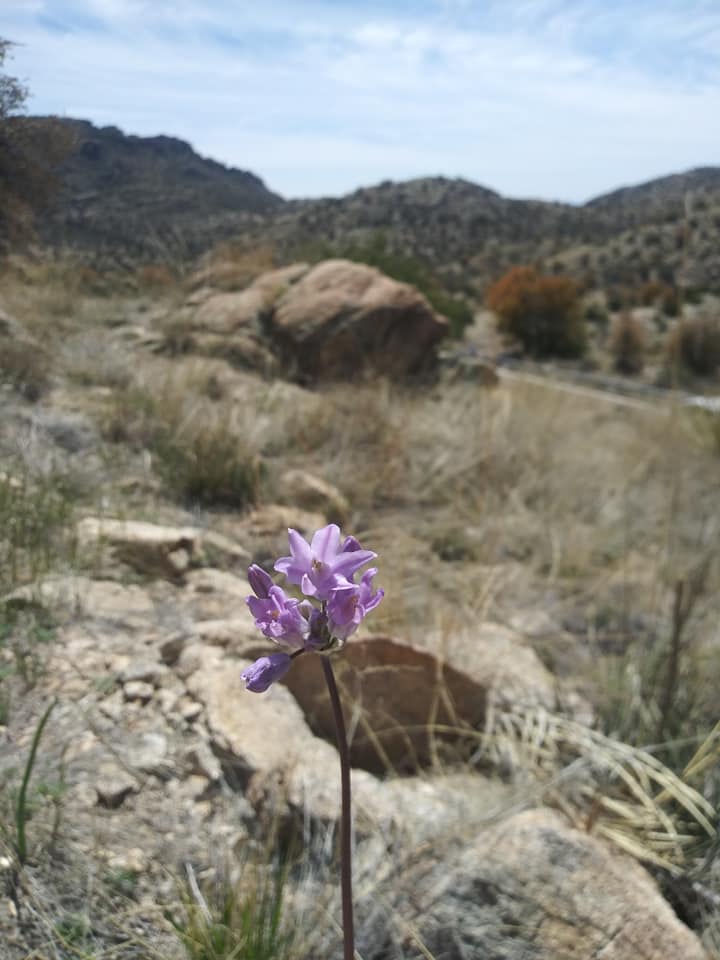
I was thus disappointed to see that the side of the dam where the trail begins was fenced off.  It looked like a landslide has completely destroyed the access road to the  Carmel River.  There was no mention of this on the Ventana Alliance website, which publishes trail updates from hikers.  The river is prone to flood and suffer repeated landslides. This is my second attempt to hike this trail in eight years.  When the river is calm, this is a beautiful lush trail to secluded backcountry.  It was one of the last hikes I did before moving from the area to New Jersey.


The dam looked to be at capacity.  Water was overflowing the spillway.  We walked down to the creek but didn't stay long.  At least we got a three-mile jaunt out of this endeavor.  The area is pretty,
but I would not want to be in the canyon during a heavy rain, as there were signs of recent landslides in the area.

I continued my drive on a county road going southeast. This is one of those narrow, scenic roads popular with bikers and cyclists.  Vineyards are hidden along this road, with stately mansions dotting hillsides.  A lot of wealth is in Carmel Valley.  This road eventually rejoins Carmel  Valley Road north of Greenfield and ends at US101. This is a small farming town and base to another pretty canyon, Arroyo Seco.  The cool weather and overcast skies did not look too promising, so I did not go to the park to see the canyon.  This will have to be on another visit in warmer weather.  I will always enjoy coming back to Monterey County.

Weather was warming up now that I was in the valley and away from the coastal area.  I stopped in King City for lunch at the Taco Bell and had to stop for a man chasing after what looked like two Maltese.  They were not his dogs.  He simply wanted to catch them and get them out of traffic.  Cars at the four-way stop sign all patiently waited for the dogs to run off the road and into the Taco Bell parking area.  I got out to help.  Both dogs looked badly matted.  I took one of Zeke's cans of wet food to lure the larger of the two dogs.  After a brief chase, the little dog collapsed, rolled over, and showed me her belly.  She let me pet her and pick her up.  She barked once in fear but didn't bite. No collar was on her and she was badly matted, with dried snot caked to the long hairs around her eyes.  The other dog ran off and the people who had been wanting to round the dogs up all went away.


The dog was also covered in fleas!  Lovely.  Employees from Taco Bell watching me told me I should just take the dog to the shelter.  Another employee said all shelters in Monterey are kill shelters.  I couldn't take her to a kill shelter.  She clearly had an owner at one time because she warmed up to me fast.  Zeke wasn't too happy losing his front seat to a matted, filthy dog, but he didn't protest.  He moved to the far back of the Honda and watched.

I ate a quick lunch and googled the King City shelter.  It's a small unmanned shelter one has to call to make an appointment.  I didn't have time for that.  My only regret is that I couldn't capture the other dog.  That other dog could have been the mother or a sibling, and now that dog would be even more stressed out losing that companion.

If this dog turned out to be a lost dog and someone claimed it, I'd just drive back to drop off the animal.  At least she was safe with me for a while.

I drove down to Paso Robles and stopped at the Firestone Walker Brewery right off US101.  That place is big!  The distribution center is also there.   This is the brewery that Eric and I both enjoyed very much when we stopped here in 2013.  The place was busy today as it was then.  This time I sat at the bar and enjoyed two wheat beers.

The little dog settled in nicely.  She stayed bundled up in my towel and dirty clothes the entire time, never wandering around the car or bothering Zeke.  I stopped one more time off Hwy 101 north of San Luis Obispo (SLO) at Cuesta Pass to get another mile in to make my four-mile quota, walking down the rutted Old Stage Coach Road to what looked like a former river bed.   This is very pretty country, and an area I've always considered the northern edge of Southern California.  I would have enjoyed staying here the night, but hiking here will have to be for another time, perhaps over my fall break when California is not so wet (but also when wildfires begin).  There are ridge hikes that start right off US101.

I had an hour of daylight.  I took CA166 south of SLO east toward I-5.  Staying on US101 would have taken me to the ocean, going too far west.  Gasoline is cheaper on I-5 than on US101.  I passed more luring trail heads like the Willow Springs trail, but couldn't stop.  I made it all the way to Palmdale and got a room at the Motel 6.  The first thing I did was bathe the little dog.  Her fur was oily and the water came out brown.  Good heavens!  But at least she was now flealess.  I cuddled with her to keep her warm, then fell asleep, only to wake up later when she peed next to me. Twice!

Thursday, March 21, 2019

Day Seven: Hiking trails of Fort Ord

I heard Eric slip out the front door at 7:20am.  I had wanted to talk to him before he left, but slept through it all.  I don't like improper good-byes.

I ended up spending a pleasant morning chatting with Margaret before heading out.  My plan was to get back to the Monterey Bay area early enough for a walk around Fort Ord's new mountainbike trails.  She texted Eric and arranged a quick lunch at the base's Burger King at 11:30am.  He got there right on time and we enjoyed a private talk for 30 minutes before he had to get back to work and I had to get on the road.  This gave me enough time for the 1300-mile drive back to Arizona.

He has 2.5 years of active duty left.  He's unsure if he's going to stay in, or get out and finish his college degree.  He's thinking of going to school in either Tempe or Tuscon.  He's not happy being an HVAC mechanic, since he wanted to join the Air Force as a Chinese linguist working in intelligence.  His dream sheet has Germany but he doubts he'll get it. (I was a Russian linguist with the Army).  Whatever he decides to do, I will support him.  I did warn him that wherever he goes after his service is over, I will continue to road trip to visit him.  I enjoy coming to California as much as I enjoyed flying to see my daughter in Virginia Beach.  (Her husband is getting out of the Navy in May and they are moving back to Northwest Indiana).

I was driving through Fairfield to get back on I-80 when Eric texted  at 12:49.  "Have you departed for Monterey?"
"Still in town, why?"
"OK.  Someone rammed into the Starbucks on base.  Just making sure you weren't inside ordering.  They smashed right through the counter."

The weird part was that I did consider stopping there for another cappuccino for my long drive back to Monterey, but opted to save time and skip the java.  Later Eric added that it was an elderly woman who lost control of her car and broke through the wall.  Six people were critically injured.  I normally sit in corners where the outlets are and would not have been injured directly, but I'm sure fallen debris would have gotten me.  Eric was sent there to assess HVAC damage.  This incident made me realize that we all need to stop whatever we are doing and thank our lucky stars for our fortunes.

https://fox40.com/2019/03/21/6-injured-after-car-crashes-into-starbucks-on-travis-afb/

Traffic was much smoother going south on I-80/US101 with few and short "slow downs."  There is also no $6 toll going this way. The bottleneck between San Jose and Gilroy is unavoidable.  That is where the highway goes from three to two lanes and traffic always backs up.  There were two regional parks in the Pendleton area; I will explore those next time.

I made it to Fort Ord by 3:30pm.  The old army fort is now deactivated, with most of the land going to neighboring towns of Marina and Seaside, with property to the University of California Monterey Bay and the Bureau of Land Management.  Most of the tank trails are now open to the public, but there are some areas still closed off for HAZMAT removal when the fort closed in 1994.  What is taking so long?!

I found a parking area off Gigling Road on Ord's southern side.  Other mountain bikers were parked here, so that told me this was a safe area to hike and bike in.  I ended up walking six miles in sandy predune habitat, up and down over rolling hills with just sporadic abandoned wooden shacks in the area.  The trails close a half hour before sunset, but there were still plenty of people out enjoying an after-work ride.

The BLM is still working on marking the trails.  Posts have already been installed at major intersections.  Trails with posts at crossings are open for use.  Closed-off trails are signed closed.  Once I figured this out, it was easy walking, down old dunes, wide paths, or under the shade of a Spanish-moss covered live oak.  I finished the loop by the old Silas B Hays Army Community building where Erin was born back in 1986.  The hospital is now a gated-in DoD building.

I finished the hike at sunset, driving toward Monterey via "Obama Way" (Broadway) in Seaside.  The walk tired me out and I was ready for two more beers at the Alvarado Brewing company in town.  I really like this place!  I didn't eat here this time, but discovered an outdoor dog-friendly patio on the west side of the building.  I kept Zeke in the car because the place was too crowded.  I got my credit card back and can now be relieved.

It's my last day in Monterey.  Tomorrow I will begin my return drive to Arizona.  I will stop at the Los Padres Dam in Carmel Valley on my way there.  I hiked there with Sadie years ago, but turned around when the trail was washed out.  The Carmel river experiences frequent flooding in that area.

Wednesday, March 20, 2019

Day Six: Lagoon Valley Regional Park, Vacaville

Rain was forecasted all day for the area.  Dark clouds lingered overhead as I got up to walk with Zeke to the nearby Starbucks.  It was 9am.  The walk there and back was a mere mile, so if it began to rain, at least we got a mile in.  Zeke didn't mind the traffic but he did mind being tied up outside the coffee shop while I was inside.


Shortly after we returned to the apartment, it began to rain hard.  And then the wind kicked in. Rain came and went for several vollies before I decided to risk getting caught in a downpour and drove five miles to the Pena Adobe/ Laguna Valley regional park right off I-80.   It was 11:30am. These are two parks in one. I had been here before two years ago with Zeke and Minnie, but this time there were few cars parked outside the park.  Looks like the city is now enforcing the no parking zone now.  Last time I was here, drivers could park outside the park gate and walk in.


I parked at the historic adobe house and walked the road to the radio tower road, a three-mile o/b road.  There was a colony of feral cats around the adobe house that were not pleased with Zeke's presence.  (These cats weren't here last time I visited, most like offspring from an abandoned cat) Wind was blowing hard here and it did begin to rain again, but this was more of a drizzle.  It was the harsh wind I didn't care for.

I stayed on the paved paths and avoided the muddy dirt trails.  More cows were grazing right off the path again and Zeke paid no attention to them.  I focused on the dark clouds moving in off the ocean.  There were a few brazen walkers coming down the hill as I was going up, but even I said "screw this shit!" and turned around with a half-mile to go to the radio tower.  By now I had made my four-mile quota for the day and was happy to call it quits and head back to the apartment.  Hiking in high winds is no fun.  And it's even less fun in the rain.

Park visitors stayed mostly along the lagoon and dog park.  Despite the windy weather, I am glad I got my walking in and didn't have to drive far to do it. I had now hiked just under five miles for the day.  The next time I visit the area, I'll hike all the trails and rack in nine miles.  I just love the Bay Area's many regional dog-friendly parks.


https://www.mapmyhike.com/workout/3439631329


I was back in the apartment by 1pm and talked with Margaret some more.  She let me use their washer and I did have a load to clean.  When Eric came through the door at 5pm he was ready to eat, and tonight's meal was at the Slanted Tree in town, a beer pub known for its burgers.  The place was busy and our only seats were at the counter, where 6'8" Tim served us.  The place serves mostly California IPAs.  They were out of the one Hefe beer, so I chose a porter.

The burgers were huge and delicious.  We all left stuffed and I was $85 poorer.   So glad we were there during happy hour, or else the beers would have been $8 each!

Tuesday, March 19, 2019

Day Five: Franklin Ridge Loop trail, East Bay

I left Monterey just before 6am.  I wanted to get out of town before stores opened.  That also meant I'd be hitting the Bay Area during rush hour.

My hike today was an unplanned hike in Martinez, an oil industrial town in the East Bay along the Carquinez Straight.   I pulled into town because I needed to get out and walk after the 3.5 hour drive in dense traffic. I found the Rankin trail by following signs to "Regional Park." I parked off the Carquinez Scenic Drive, walked up steep Foster Street and got on the Rankin Trail.  This trail continued uphill, past the cemetery, before joining the Franklin Ridge Loop and Bay area trail.   This was a 4.5-mile loop hike along a ridge that overlooked the water.  How verdant it was here!  This was like walking a Volksmarch in Germany.  Black cows grazed along the hillside to my north, where I spotted what looked like a small dairy farm.  I could hear the commuter trains and ships blasting their horns below and traffic speed by on the Benicia-Martinez bridge (I-680), but now I was all alone.  The open spaces in California always impress me because they provide the room for exercise and are away from the crowds.

Parts of the trail were still muddy from recent rains.  The ridge trail was exposed, but at two miles the trail then descended, then looped around a canyon creek where more shade provided some cooling.  Zeke ran down to the river just as another lone dog walker went past me.  Did he even see me behind the trees?

I enjoyed this walk.  It was still cool out, with the marine layer (fog) still in the higher hills.  The trail is well-marked, with more horse trails off the ridge trail that go down into other draws.  I had walked two hours and it was now late morning.  I was ready to continue my drive to Travis Air Force Base outside of Fairfield.

I was at a Taco Bell in Cordelia when I realized I was missing my credit card.  I had left it at the brew pub in Monterey and the employees have it.  I told them I'd be back Thursday and they said they'd keep it safe for me.  Luckily there is a branch of the Armed Forces Bank on Travis, where I withdrew enough money to last me two days.  I certainly didn't want my son to pay for our meals!

I showered at the base fitness center and had coffee at the Starbucks (an excuse to surf the net as well) for another two hours.  Eric wouldn't be getting off work till 4pm and I had time to spare.  I waited for him to call me back and he just told me to stop by his apartment and chat with Margaret, which is what I did.

Eric didn't get home till almost 6pm.  His supervisor had a last-minute meeting to discuss unit improvements and that held him up. We were all hungry by then.  We drove in separate cars (because Zeke rides with me) to Los Reyes restaurant in Vacaville.  Eric and I had eaten here before at my last visit to Travis AFB two years ago.  It is a nice Mexican restaurant in old town, off a creek.   I would have enjoyed a post-meal walk in town but Eric was tired so we just drove back to his place.  Within an hour he was in bed and I was up till past midnight in the living room on their couch.