Friday, March 30, 2018

Hog Canyon to El Pilar (Santa Rita foothills)

Distance: 2.7 miles
Elevation gain: 410'
Significance: spiral rock formations, watering holes
Trailhead: unmarked.  Take SR 82 west of Sonoita, turn on Hog Canyon road, a dirt road.  Stay to the left on FR 627.  Road takes as general southwest direction.  Pass corral with two barbed-wire gate 200' apart.  FR 627 is now FR4088.  Continue on this until you see another barbed wire fence and Mt Wrightson in front of you.  Park here and take trail down into Adobe Canyon.  Trail meets with northern turn-around of Adobe Canyon Road.

Rod led a hike a few years ago to El Pilar from Gardner Canyon Road.  I enjoyed that hike so much, I've been wanting to go back there via a shorter route.  Rod led this hike in January and today I finally repeated it.  Hog Canyon is the most direct trail to the water oasis.  Steve and I agreed to get together after Zeke's 9:15am appointment for a Lyme's test at the Sierra Animal Hospital.

Today Dr. Rufle was my DVM.  He's an older gentleman.  He told me that a blood panel would determine if Zeke has Lyme's disease.  The $181 blood test showed he did not.  That's a relief!  His liver tested borderline low, which Rufle said was also good.  My only concern is Zeke's weight of 63 pounds.  He weighed 60.3 two weeks ago, but perhaps there was a discrepancy between the two scales.

I made it to Steve's place by 10:30am.  We didn't get going right away, and we should have, because it only got warmer as the day went on.  The drive to west Sonoita takes 90 minutes, plus the four miles on dirt forest road once in Hog Canyon (off SR82).  I'm glad I photographed Rod's trip report from the last El Pilar hike, as I'd have forgotten turning on  FR627 and then FR4088.

Hog canyon is a popular quail hunting and ATV area.

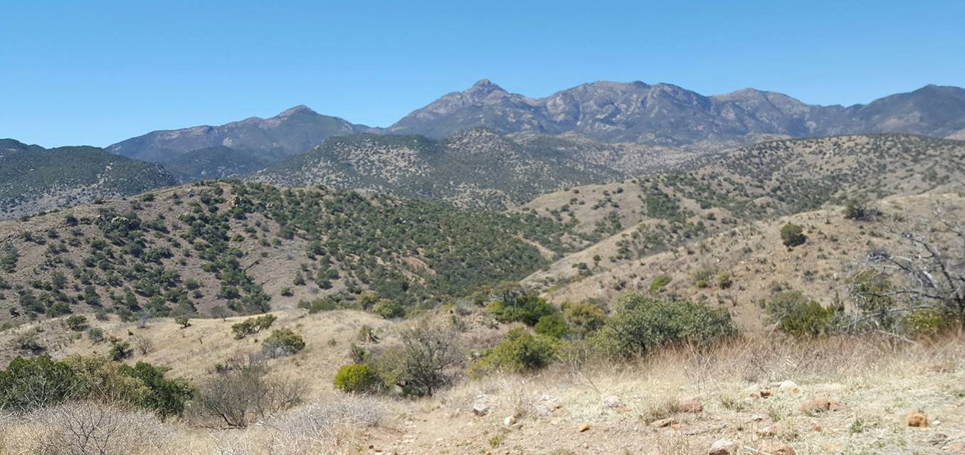
When we got out of the truck to start our immediate descent into the canyon at 12:30pm, Steve stood back and asked to stop to enjoy the view.  "This is quite beautiful."  Mount Wrightston stares right at you from this location at the unmarked trailhead.  With some rain comes more color and then this view is breathtaking.


The descent is exposed, loose rock and at times steep.  Despite the mere 2.7 miles we did today, it sure did feel longer.  The heat got us all, dogs included, right away.  Zeke didn't even want to get out of the truck, and once on the trail, ran to any shade he could find.

The trail descended to the northern end of Adobe canyon and the dirt road.  I could see the rock spirals unique to El Pilar so we walked toward it.  And I was right!  We got to the El Pilar ladder, with the shade and water for the dogs.  This was another great rest for us.  At one time this was a dam, one of several along Adobe creek.

We were alone here with our two dogs.  Both clearly enjoyed the water.  Hikers can climb up the ladder and walk the rocky creekbed farther, but we had to turn around here.  We had gone only one mile!

On the return hike, I saw a patch of fresh green elms in a side canyon and told Steve I wanted to explore that.  Those trees were the landmark for the El Pilar tanks, another water oasis.    Here again, we rested.  The only wildflowers on this hike were here.

Since we had the dogs and couldn't make a loop hike like the others in January did, we simply went back the way we came.  It made for a strange route.  On a cool, overcast day this would be a lovely hike, but we were both a little overheated from the exposed 75F temperature.  The fascinating, unusual rock formations here are quite intriguing.

Now I at least know how to get to these watering holes.  I will come back and explore it some more when it's not quite so hot.  Adobe creek farther north has deep watering holes were turtle hide out.


This hike took us 2:40 hours.  Elevation gain was just 410'.

We stopped again in the Copper Brothel Brewery.  We each had two beers but skipped a meal.  We both kept talking about how long it took us to walk the mere 2.7 miles.

On my way home I saw a near full moon rise.  The full moon is tomorrow.

Shortly after coming home I developed an intense headache that lasted well into next morning.  I'm sure I was severely dehydrated.


Thursday, March 29, 2018

Copper Canyon and a walk to the border (southern Huachucas)

Distance: 6.3 miles (1.4 miles to mine and back)
Elevation: 5938'-6632
Elevation gain: 1265'
Significance: abandoned mine; scenic walk to the international border.
Trailhead is two miles east of Montezuma Pass on FR 61.  Look for Copper Canyon sign.


School got out at noon for our Easter break.  I dropped off the recyclables (I always bring them with me to work on Thursdays as it's the only day I can make it to the nearby transfer station after school) and drove home to pick up the dogs for a hike in the Santa Rita foothills.  It was 1:15pm. Then I checked my text messages (which I don't do regularly enough) and realized that Nina was in town and was looking for some company over lunch at 1:30pm.  So back into town I went to have a quick lunch with her at Native Wings until she had to leave at 2:40pm for her dental appointment.  Claire was also there.  I hadn't seen her in almost two years. It was nice to catch up on old friends.

Having lunch with Nina and Claire was an unplanned, but welcomed distraction, but it also meant I had lost two hours of hiking.  I thus changed my plans from the Santa Ritas to the southern Huachucas and Copper Canyon. I had never been in this canyon.  I packed the dogs in the truck and off we went.  The 30 miles took 50 minutes, through the Coronado Memorial, up to Montezuma Pass and down the pass on FR61 to Copper Canyon.  Copper Canyon is the first road intersection west of the pass.  I parked the truck and we took the mining road uphill at 3:36pm.

The road is steep and rocky, but shaded by oaks and sycamores.  The old mine is 3/4 mile up the road.  Water flows out of this mine tunnel, and this water was a nice relief for the dogs as I packed only a pint of water. We explored the mine area, went above the tunnel to find more artifacts, with pretty views south into Mexico.  There has been recent erosion here, but I'm sure in the monsoon season this place would be teeming with birds and a small waterfall.   The road stops at the mine.  The terrain from here on north is too steep and overgrown so I walked back down.

Former USBP neighbors of ours had told me that Copper Canyon was a popular place for smugglers to pass through and to be careful hiking here.  This was the reason I never ventured here before.  When we first moved here in 2004, we'd find mounds of abandoned backpacks, rusty tuna cans, sun-bleached clothes. I saw none of that today. The water is what perhaps draws the smugglers into this narrow, steep canyon, but north of the mine is nearly impassable.


The canyon walk was barely 1.5 miles round trip.  While this took me 1:20 hours, I wasn't ready to go home just yet.  It was 4:30pm with enough daylight to walk down FR4781 to explore the border.  I had never seen Coronado Peak from the western side.

A truck camper from Oregon was parked across the road from me.  A dog inside barked at us but my dogs were calm.  They seemed to understand that their mission was to hike south on the road.  We passed a surveillance station, an old cattle corral, and continued on the road to the border.

Coronado Peak expands south here and one can see the massive rock slabs on its southwestern slope.  Mineral debris mark where water flows in the rainy season.  Half a mile from the border and I could see the old hedgehog fence.  The near full moon then popped over the ridgeline.  It was as if I had planned this.

Yaqui springs is just north of the border, high up a steep and narrow draw facing the southwest.  It's tempting to go up these rocks to explore, but is it safe, or even legal?  If that is part of the Coronado National Monument, then dogs are not allowed.

This is rugged terrain.  My first time exploring Coronado peak along its park boundary with Sara, Sammy and Sadie, I came across an armed USBP agent lying on the ground with his AR-15 aimed at the border.  He was watching drug smugglers move across the border.  That was a scary sight.  Sadie was around two years old then and we were on an "illegal" trail that started behind the park's restrooms by the parking area.

Fifty feet from the border I came across another white cross dedicated to a fallen border crosser.  The cross listed SONIA ALVARADO SORIANO, age 25, who died at that spot under an oak tree on August 29, 2007.  It seems so tragic to die just inside north of the border.  A nonprofit organization in Cochise County is erecting these white crosses wherever migrants die on their journey within the county.  This is the fourth cross I have come across in the last two, three years.


I rested on the border to let the dogs relax.  Minnie was panting by now.  The two miles to the border on the exposed road, despite the low sun, had exhausted her.  The dogs drank their water, rested, and we returned the way we came.   The walk north is just as beautiful as the walk south.  I seldom see the Huachucas from this perspective. Now the sun was even lower and the shadows cooler.  Suddenly Minnie wanted me to play fetch with her.

I made it back to the truck at 6:49pm.  The dogs drank more water before I made the drive back over the pass for a nice sun set.  What a beautiful drive this is any time of day.  To the south I could see the lights of Cananea, Sonora.


The dogs and I got a good work-out.  This turned out to be another great unplanned hike close by.  I could do a loop hike from Copper Canyon, using forest roads 5714 and 4781 for a comfortable six-mile hike.  The new surveillance stations along the border have cut down on the smuggling through this area.  There is no need for a wall here.  A wall would destroy the natural beauty of this place.
http://www.mapmyhike.com/workout/2791391951

Sunday, March 25, 2018

Along the AZT: hiking south from Gardner Canyon Road

Steve and I never did hike to El Pilar tanks.

I somehow missed the turnoff to the road that takes one into Hog Canyon from the north via Gardner Canyon Road in the Santa Rita foothills, so I immediately opted for plan B, which was to hike the AZT south for three miles and return the same way, making for a comfortable six-mile hike in the same area, across the alluvial plains and riparian habitats of the eastern Santa Rita foothills.   This is part of Passage 4, Temporal Gulch, of the Arizona Trail.  (There are 43 passages) Skies were overcast and it was in the upper 50s, but it never became windy as forecasted.

 
The hike started out rocky, down to the creek and then with an ascent up a few switchbacks to an oak-studded meadow, along the side of several hills as the trail followed a creek that parallels the Santa Rita Road.  We went through five cattle gates.  There were many horse droppings on the trail.

The 2005 Florida fire, which burned 36 square miles, destroyed old Douglas firs, caused a landslide that buried part of Cave creek, and destroyed so many of the oaks in the area we were walking in.  A sign warns hikers that one is entering a burn area.  Many of the old, burned trees along Santa Rita Road have been preserved for wildlife to use as shelter.


Several historical hydraulic features are along this stretch: pipes, a penstock, the Stetson Dam (which once was 10' high and 100') that collected much-needed water for gold extraction in the area and several other mining-related artifacts.  The Forest Service even has signs erected for the hiker to read up on the history.  This was a busy mining area early in the 20th century.

Despite recent rains, the area is very dry.  We didn't see any wildflowers.  The only plants in bloom were the manzanitas. The hillsides were dry and dominated by browns, greys and dark greens.  Many of the oak leaves were yellow.  Steve said that's how oaks shed their old leaves for new growth
 

We stopped at a campsite off Santa Rita Road and the creek, had some snacks and returned the way we came.  It was getting warm now and the dogs were panting.   We were lucky to have had mostly overcast skies for this hike, because the exposure on a hot, cloudless sky would have been more uncomfortable for us all.  Had we hiked 1/4 mile farther, we would have reached Tunnel Springs and begun the ascent up Walker Basin.  That will be for another day

We now were ready for the post-hike brewpub in Sonoita, the new Copper Brothel Brewery recently opened by a transplanted Colorado family.  Robert and Cheryl Jesser built this steel structure and daughter Samantha (Sammie) is the brewmaster.  She plans to have four to six beers ready in about six weeks.  Right now there are only guest beers from around Arizona on tap, most of which I have already tried.

The place was busy and we were told that food would take about 45 minutes.  Yikes.  Don't say that to two hungry hikers!  We ordered shredded beef nachos.  I had two beers, Steve had one, the Lefthanded Nitro Stout out of Colorado.  The woman next to us at the bar was impatiently waiting for her appetizers.  She had been waiting 40 minutes.  She ate her food and promptly left.

The people are still working on the kinks.  I plan on coming back to try their own beer.  The place has a large seating area, with a small outdoor area facing the south.

Saturday, March 24, 2018

Crazy, stormy weather


High winds were forecasted for today, but it didn't really begin to howl until late in the morning.  By then I was hunkered in bed, finishing another book review.  I kept telling Kevin I'd be leaving "soon" for the All About Animals event in town, an annual event hosted by the Greater Sierra Vista Kennel Club.  It was scheduled for 9am-3pm.  I missed it the previous two years, but was there for the first event which sponsored dog agility, working, herding, jumping events, dog adoptions, dog training, etc.  The best part for me the first time was talking with other dog owners and taking photos of humans and animals interacting.

I didn't leave the house until 12:45pm, in perhaps the windiest part of the day.  My truck was shaking as I drove north on SR92.  I saw a full-sized pickup lose three barrels of hay just south of Ramsey Canyon Road: wind had picked them up and threw them across the road.  Luckily the hay missed my truck!

Skies were looking dark to the east.  When I got to the Veteran's Memorial Park parking lot, cars were leaving.  I ended up catching about ten minutes of people holding on to tents, people tearing tents down, putting animals back in their crates and vehicles, and people holding on to their hats.  The various animal shelters were told by the county sheriff to shut down early because of the incoming storm.  The event was supposed to last until 3pm and it was practically over by 1pm.  I should have come three hours earlier! I caught several workers from the Huachuca City animal shelter where I volunteered over three years ago.  They had two older GSDs for adoption, Tom and Jerry, two older dogs that had been at the shelter for three weeks.  Both dogs looked uncomfortable in the undersized crates.

I stopped at the grocery store briefly. The rain began as I drove back home.  Poor Zeke was with me and hoping for some exercise.  I promised him a walk after the winds died down later.  My phone registered winds as strong as 37 mph.  By 3pm that had died down to 24, and by 4:30pm it was a tolerable 13mph with the rain having moved east toward El Paso.

That gave me just enough time to hike up Thompson Ridge, my three-mile r/t, 1056' elevation gain switchback.  The ridge sits at 6740.' I took all four dogs.  The road was surprisingly dry (no mud!) and the winds were minimal.  I had just enough time to do this hill without pushing it before sunset.

The overcast sky was ideal for the dogs, especially Minnie who easily tires in the heat.  I made it to the ridge in 40 minutes and then sat there for another five, taking photos and watching the storm clouds over the peaks.  Winds weren't too bad where I sat.  I didn't see another soul, but I didn't expect a normal person to want to venture up in weather like this.  Even the dogs seemed to enjoy the views, as they took turns gazing into the distance.

I know they enjoy these little hikes in the wilderness.  Perhaps my friends are right when they tell me that my dogs are lucky to have me as their mom because I take them places.  Hiking with them, therefore, was one goal I achieved today;  the day wasn't a total waste.  Weather tomorrow is supposed to be cool but sunny and Steve and I are going to do a foothills romp in the Santa Ritas.  That's another lovely area I enjoy walking around in.
The sky opened up nicely on the short drive back home and I got to see a beautiful color display toward the Dragoon Mountains from Hereford Road.

Ellen participated in the "Dawn to Dusk" bike ride in Tucson today and told me winds and rains never got as bad as they did in our little corner of the state.  Steve was also in Tucson looking at RVs with his friend Kel.  Hope they had a safe drive back to Sierra Vista.

Sunday, March 18, 2018

Vaccine clinic

I had driven 1440 miles to the California coast and back and hiked 48 miles over spring break.  It's hard to maintain that activity now that I'm back in school.  I feel great, though, and want to maintain my fitness level, perhaps hike up Thompson ridge on a weekly basis, do some speed walking, maybe attempt short runs.

Today was not a busy day, though.  I did my usual morning reviews, then took Sadie and Zeke to the twice-monthly vaccine clinic at Tractor Supply Company in Sierra Vista, contracted with PetVet out of California.  I like their services and prices.  Zeke was overdue on his 5 in 1 pack and both needed their rattlesnake vaccine.  This year I'm skipping the flu shot and instead had both tested for heartworm since I was in California for a few days.  Minnie and Sweetie will get their shots during the next clinic in mid April.

I got to the vaccine clinic at 2:30pm and was the last in line.  An older couple in front of me had their AKC Rough Collies, siblings Kacey and Maggie, 7-years-old, in for their annual shots.   That's a breed I've always enjoyed, but you don't see too many of them these days.  "The 1960s TV show 'Lassie' made the breed popular," said the elderly Mr. Healy as he cuddled with Kacey, "but they sure do shed!" His wife Ann, next to him, quietly nodded her head in agreement.

A young German Shepherd pup was in the front getting his shots, and as usual with the breed, it howled with dramatic flair.  Sadie barked back as the pup left with its mom.  A young dad with his two daughters came in to get their two shepherd-Husky pups vaccinated.  People came and left without much ado.

The crowd was well-behaved and quiet.  I even bought some vegetable plants to place in the ground when it warms up for real. I spent $187 on the dogs alone.

And at 5:30pm I took the dogs out for a 3.2-mile walk along the ATV trail off Avenida Saracino.  The Forest Service has now filled up the lower stockpond with water, which makes it easier for the dogs to get to.  Naturally, they wanted to dive into it as we walked past. I just wanted to get the walk done as quickly as possible.

Thus ended my spring break. Back to school tomorrow.

Saturday, March 17, 2018

Double peak bagging up Miller and Carr Peak with Ellen and Zeke

Distance: 13.9 miles
Elevation gain: 3207'
Significance: This is a challenging dayhike close to Sierra Vista. No need to drive far or spend money on parking permits.  Both peaks offer panoramic vistas.
__________________________________________________________


The Forest Service has opened Carr Canyon Road for the season. Today was Ellen's big 14-mile hike up Miller and Carr, an out-and-back hike along the Carr Peak and Crest Trails in the Huachucas.  We had done this route two years ago with her friend Adam.  Sadie and Zeke came along on that hike.  Today I only brought Zeke.

The cold blast that hit Los Angeles on Thursday, which was the reason I left a day early, arrived in southern Arizona overnight.  I could hear the winds howl.  It was 2am, I was wide awake, and I really didn't feel like hiking 14 miles today.  When the sun came up,I could see clouds racing across the peaks.  A heavy fog lingered over the mountains.

And yet we still did this.

Ellen and I met shortly after 7am to drive to the Sawmill trailhead across from the group campground on Carr Canyon Road.  I wore a dryweave shirt under my sweatshirt but quickly realized that wasn't going to keep me warm.  A black raincoat packed for the peak was put on before our hike.  We took off at 7:39am as clouds overhead blew by. Winds were gusting.
 

A mile into our hike we both questioned our sanity, but we trekked on.  We could see frost on the highest pines near Carr Peak, and Miller was still shrouded in fog .  (That frost was melted by the time we were on the return hike.) Hiking in fog on a summer day is refreshing; not so much in the winter when it's 50F and gusting. Parts of the upper trail were still moist from melted snow.  Despite feeling fatigued yesterday, I had energy today and didn't slow Ellen down.  She said I was averaging 2.3 miles an hour.


The northern slope sections of the trail were calm, which broke up the blasting winds.  Ellen lent me a beanie to keep my ears warm.  When we hit the Tub Springs at 4.2 miles, the winds felt calmer.  The surrounding trees protected us from the wind. We stayed there a bit to talk to an Arizona Trail hiker from Toledo, Ohio.  He was Frank, aka "Skink" who has until April 24th to finish the 880 mile section.  Last night was his first night  on the trail, and he told me how he was being followed by someone, but that someone moved back whenever he got close. Both were shining their headlamps on each other.  (I'd have yelled out in English to see if that was a USBP agent).  A man sleeping wrapped in a tarp was near the tub as well.  This southern section of the Arizona Trail is notorious for drug smugglers passing through at night.  I would never camp out here, even with a pack of dogs.

It was 10am and Frank was just getting ready to push on to Parker Canyon Lake 18 miles away.  We had to make way for two equestrians moving north on the Crest Trail.  Horses are not allowed in the Miller Peak Wilderness.  The horses left deep grooves in the wet soil.  These grooves are going to be dangerous for night hikers if they get their feet caught in one and stumble down the steep embankments.

We made it to Miller Peak shortly after noon. It was blustery here as we sat on the old foundation eating our lunch.  Zeke cuddled behind Ellen to keep warm.  He wasn't interested in eating his raw steak.  It was windy but there were no clouds overhead.  The trees below us all looked thirsty for a heavy rain.  I was glad to notice many new pines growing in the burn area.  The ridgeline is coming back with new growth!


At 12:36am we descended Miller Peak to return to Carr Peak.

Frank was long gone as we returned to the tub for another rest before continuing on to Carr Peak.  A yellow-eyed Junco seemed unbothered by our presence, as it circled around us pecking at the ground.
We got to Carr Peak just before 2pm.  Here is where we finally came across other day hikers.  Winds were calmer here, perhaps because they were broken up by the nearby brush.  We had another snack, took some photos, and descended this trail for the 3-mile finish.

 We got back to the car at  3:10pm.  This was a 7.5 hour hike with 13.9 miles, using Ellen's Garmin watch for data.  We were all tired, even Zeke.  We drove to Culver's in town for dinner.  Zeke rested all night long.  I gave the dogs that stayed at home a raincheck; I was too tired to go out and walk some more.