Saturday, April 29, 2017

Arizona Trail: Canelo Hills South from Harshaw Road to Gates Spring (12. miles r/t)


http://www.mapmyhike.com/workout/2159570207

The Canelo Hills north of Parker Canyon Lake to just south of Patagonia are perhaps one of the more scenic stretches of the Arizona Trail in extreme southern Arizona.  The rolling hills provide for a physical challenge without exhausting the body, yet provide scenic views and springs along the way.  The only living things you may share the trail with is cattle.  I like hiking here.  What keeps me from coming back more often is the 66 miles it takes to get here from Hereford.


I had hiked this stretch before with Sara and Sammy, perhaps after coming back from Iraq in 2008.  Back then I made it three miles into the hike but couldn't find the trail past a wide, shady wash.  Signage had gotten eroded and I turned back.  Today the trail was much easier to follow, up and down the hills, and in some places the original trail was improved to make traversing it easier.


I started at 1:27pm.  The parking area was empty.  After realizing I was on an illegal trail, I turned around and saw the official trail sign across Harshaw Road going northeast and up over some hills.  Then I remembered that that's the trail.  Sadie and Zeke were by my side.  I never met another soul on this hike.

The trail quickly ascends.  Starting elevation is 4086' but jumps to 4511' at the 1.5-mile mark.  Views into the artsy town of Patagona come to view, along with some architectural homes hidden by hillsides.  Red Mountain is the prominent mountain here south of town and its hilltop antennae shine in the sunlight.  It makes for a prominent landmark along this section, as well as another hill east of there with several protruding mines visible.  This mined hill was north of the AZT and glistened in a golden hue on my return hike several hours later.

The first thing I noticed across the entire landscape was how parched the flora was.  The dead grass was a dull brown, creating a mostly monochromatic landscape of shades of brown.  Even the hillside oaks looked parched, with many of the leaves yellow or brown from lack of water.  Trees along intermittent streams and washes fared slightly better, but the lack of any recent precipitation was obvious.  We need rain!

I had water with me, enough for the dogs and me.  Zeke quickly began panting again, though.  He trotted next to me looking fine, though, so we didn't stop until 3.7 miles into the hike when we crossed an ATV trail marked Canyon Road that went northwest.  I had no plans to turn around at a specific point; I based my hike today on remaining daylight.  All the mattered was that I return to the truck before dark.  It was already 3:43pm by this time.  I could hike until 4pm before turning around, I told myself.  Red Rock Canyon was five miles from the trailhead; I could reach that.

The landscape leveled out some once I crossed Canyon Road.  Red Rock Canyon came into view, with its red rock strata high enough to act as a landmark, but the hills looked farther away than posted.  My GPS was telling me I was past the five-mile mark and I was not in a red canyon.  So I continued on.  The varied landscape lured me farther along.  Trees were starting to green up some and the trail passed along a level flood zone with evidence of recent cow passings.  After a heavy rain, this would be even more inviting.  At one point, mesquites canopied the trail, providing shade for cattle and hikers.

More later


Monday, April 17, 2017

Miller Peak from Montezuma's Pass


My friend Steve is getting ready to head out to Texas for ten days and expressed his desire to hike up Miller Peak, a summit he hadn't bagged yet.  Since I was due a peak this month, decided to join him.  When he emailed me on Sunday saying he was able to hike on Monday, we agreed to meet at 6am at the parking lot to start this hike.

I was seven minutes late. I was too late to watch the sun rise from the parking lot. (Why did I think it would be a 15-minute drive to the trail head?  It's more like 25 minutes!)  "Nina has been rubbing off on you!" said Steve as I pulled up, referring to Nina's incessant habit of always being late.  It took another 12 minutes to get all my stuff ready before we took off at 6:19am.  Zeke seemed hesitant to get out of the truck and hiked slowly behind me the entire time.  This was a concern for me as he's normally exuberant and alert. Have I been pushing him too hard?  Does he have an injury or illness?

The only people at the trail head were Border Patrol agents.  For the entire  duration of this hike, we were the only ones on the trail.  That was fine with us.  As soon as we got to the trail we took our dogs off the leashes.  Trace flushed a few flocks of birds but Zeke heeled to me the entire time.  I stayed in front to take pictures, stopping to allow Steve to catch up with me.

Steve had researched the elevation of the trail and knew what he had volunteered for.  There is no easy way up to Miller Peak:  elevation gain is around 4000' no matter from what trail one starts at.  This southerly approach is the easier approach, but that's not much consolation while hiking up the grade.

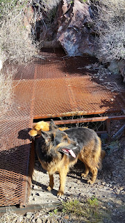
Steve started out strong.  He has been hiking regularly since returning from Texas last fall and I saw improvement in his pace since our joint hike up Carr Peak last October.  But he soon tired after the first mile. There are three abandoned and closed mines in the second half of the second mile that interested him.  There was no water in the spill drain by the third mine shaft, something that can provide water to a thirsty dog.

It's 1.8 miles from trail head to the Miller Peak Wilderness boundary and once we got to the wilderness boundary, we took plenty of stops to rest.  Zeke continued to look tired and didn't drink much.  What he didn't drink, Trace gladly finished for him.  But I soon experienced a leak on one of my half-gallon plastic bottles, perhaps a pinhole puncture   that made me loose a pint of precious water.  I wanted to make sure the dogs had enough water.  We stopped to pour what water I had left in Steve's containers.  That gave me access to a quart of water which I had to ration.  My pants and back were wet from the leak.


The trail's grade lessens in elevation gain once in the wilderness, but after a half mile of relatively level terrain, another ascent is felt.  "I thought you said this was level!" said Steve somewhat disapprovingly.  The ascent begins as the trail slowly gets ready to jump over to the western side of the ridge via several rocky switchbacks.  I learned fast to no longer add commentary to the trail.  What's level to me is not level to someone else.

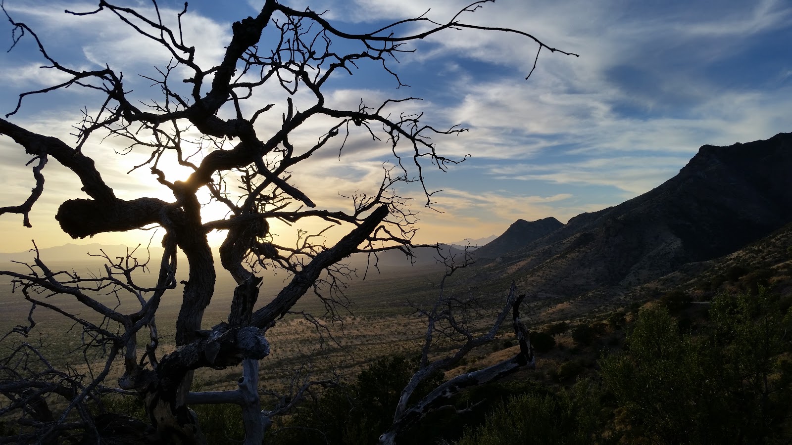
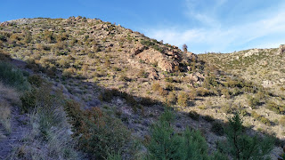
The southern Huachuca Crest Trail (part of the Arizona trail) suffered extensive damage during the June 2011 fire.  Sadly, no new Douglas firs are growing where once old growth stood.  The scrub oaks that have regrown since the fire are now suffering from drought again; so many leaves are turning yellow and dropping.  I see that color change even in the valley.  The winter rains helped only while it was raining and we've had a warm, dry spell since early March.  We only saw four kinds of wildflowers, too:  red cardinal, purple lupine, small white cluster flowers and small yellow prostate flowers near the peak.  Dry weather prevents flowers from blooming and the mountains looked dry.

The morning sun was still low enough to provide some shade once we were on the western ridge.  We stopped a lot, averaging a mile an hour.  Zeke rested in shade whenever he could.  He drank some but let Trace take his snacks.

Once we made it to Lutz saddle we had a mile to go before going on the spur trail to the summit.  Steve was determined to bag that peak.  Lutz saddle suffered minimal damage during the fire and thus is one of the few shaded areas left with mountain grasses swaying in the wind.  We rested again here, among visible signs of border crosser camp sites: empty cans of albacore tuna "en aciete" were near a rock fire ring; I took those back with me on the return hike.


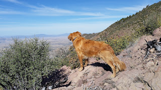
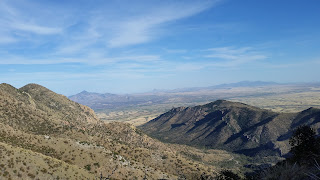
We stopped to look at the eastern view.  I pointed out well-known landmarks:  Lutz canyon and the steep trail to the top, old mining sites with what looks like overgrown mining trails no longer listed on current forest maps. And, as expected, the trail takes another steep ascent in that last mile as it passes through a half-mile rocky cliff, with its natural stone steps and loose rocks that can twist even the hardiest of ankles.  The views to the west from here are spectacular and that makes dredging up this trail worth it.  Here's where I like to linger, too, along a narrow stretch of unburned old growth pines.  The burned section reappears again at the turn-off to the .5-mile spur trail to the summit.


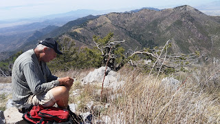
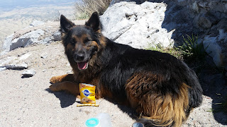
We made it to the peak at 12:20pm; a six-hour ascent.  We were all tired.  There was no shade for us to sit under.  The only tree that survived the 2011 fire, an alligator juniper, had insects flying around its tiny blossoms.  We ended up staying long enough for a few photos, a water break for the dogs, and didn't have our lunch until we got back to shade 1/3 mile from the top.  By now Zeke and Trace were showing signs of fatigue.  I discovered that I had left my lunch, a McDonald's HotN'Spicy chicken sandwich, in the truck.  All I had was a bag of trail mix.  The full exposure to the sun made the cooler temperatures negligible.


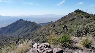
Both Steve and I knew we couldn't linger very long if we wanted to get back to our vehicles before sunset. The descent felt no faster than the ascent!  What worried me now was facing the western slopes in that hot afternoon sun.  My thighs were starting to feel tight.  We rested again in Lutz meadow before bracing ourselves for the two miles of exposed ridgeline interrupted with a narrow patch of oldgrowth.  I told Steve I would walk as fast as I could through this section but wait for him whenever he got too far behind (= out of sight).  He kept up well.  Steve later told me I don't hike really all that fast, but only that I hike in front of him.

We got some relief once we were back on the eastern slopes, with the sun now off of us, but we weren't going any faster.  Dog and human were tired! We made it to our last rest stop, right outside the wilderness boundary, at 4:30pm.  That gave us two hours of day light for the last two miles.  We barely made it.  But once we did, we were all relieved.  USBP agents were getting ready for their evening shift.  Again our vehicles were the only non-government vehicles in the lot.  I chatted with one agent while waiting for Steve and Trace.  I asked him what he thought about a wall along the border here, as promised by Trump. "By wall he means our advanced technology, not an actual physical wall" replied the agent.  Really?  He also said that the illegals who cross over along the border near Montezuma Pass are from Guatemala and Honduras.  "The Mexicans cross over along the San Pedro River."

We ended up having a meal at the Golden Corral.  It was just before 8pm and the dinner rush had subsided. We stayed there an hour celebrating our accomplishment.  I'm glad I bagged Miller Peak with Steve, but it's a peak I probably won't be doing again until this winter.  My leg muscles were challenged today.


Monday, April 10, 2017

Tombstone rail road trail

I had time today to pay Chip a visit, the widowed husband of my late friend Carol.  I had not seen him since before Thanksgiving.  Attempts to call him earlier this week always resulted in the connection getting cut off, so I drove to Tombstone to see if he was OK; the phone connection had always been adequate in the past. Today I arrived unannounced, something I prefer not to do.

It was after 3pm when I arrived, with Sadie and Zeke in my van. I had planned on taking them along the old rail road trail after the visit, an easy hike from town.  Both dogs waited patiently in the van for me to drive off, but Chip said it would be OK to let the dogs out and sit with us while we chatted in the car port under the shade.  Chip's three small dogs barked incessantly the entire time from the front yard while Sadie and Zeke were quiet.  Sadie sniffed around the area but Zeke sat right next to me.

"Those are well-behaved dogs" complimented Chip.
"Yes, they are," I replied.  That's the reason these two dogs travel the most with me.

Chip looked much better today than in previous visits.  His white beard is filled out, the bags under his eyes are less pronounced, and he no longer sports a frail physique.  He is more at ease again now that his DUI case from last fall was dismissed when the toxicology report came back revealing the only drugs in his system were the prescription drugs for his various ailments.

This was the first time we both were able to talk about Carol without either of us getting choked up. We are making progress.

I stayed until 5pm.  The dogs were getting restless and the small dogs were not able to relax.  On my way back home I decided to walk the old rail road trail near the Post Office, the same trail that EricT had used as a hike with the original MeetUp group.  It had been so long since I walked it, I couldn't remember where the starting point was.  I thought it was south of the post office.  It's actually just north of it, on Bruce and Haskell streets and travels generally in a northeasterly direction on what once was the rail road.

I started the hike at 5:28pm.  It was sunny and hot.  I made a few wrong turns and had to climb up a hill before I could see the actual trail.  It's farther north than I remember, and closer to SR80 than I thought. Once on the trail it was easy walking, albeit somewhat boring walking because the trail runs straight without any change in the scenery.  Thornybush line the trail on either side.  There were others out exploring these town trails, which show proof that ATVers and horses come here quite often.  I was just out to exercise the dogs and get some miles in.  My thoughts carried me through the monotony.  I wanted to get to the old rail road trestle and the dry creekbed of Tombstone Gulch before turning around.  My thoughts wdere interrupted a few times when Zeke spotted several groups of deer to chase.  There were plenty of deer out tonight.

It's a three-mile walk on the old rail road trail to the Gulch.  I got there as the sun was ready to set.  This is where the trail gets scenic as it meanders down into the Gulch.  A old spilldam is nearby.  The trestle is badly eroded but the trail continues on the other side.  Some day I'll explore this side of the trail.  For today, though, I had to turn around while there was still some light.  I didn't want coyotes to think my dogs were easy targets for a meal.

In some ways today's hike was in memory of all the great hikes I had with the people I met through MeetUp: Nina, Claire, Robert, EricT, SusanM, HollyW and HollyO, Bill and many more.  We hardly seem to have time anymore to get together.  HollyO is now in Alaska, HollyW is back to working parttime, EricT now lives in northern Arizona, Claire is now working and can't take off time to hike during the week, and Robert tries to avoid me.  And soon Nina is moving to a new home in Vail, AZ, where trails near Tucson would be easier for her to reach.

The dogs enjoyed their walk even though they didn't have any water to drink.  I was getting thirsty, too. There was water in the van, though, so I wasn't worried of the dogs suffering from thirst for long.  With the cooler evening temperatures it was easier to continue hiking without feeling thirsty or having the low sun in my eyes.  There were other people from the nearby Best Western Motel off SR80 walking the desert trails, perhaps to catch the sunset or moon rise. I could hear coyotes howl to my West.

I sped up my pace so that I wouldn't be out in the dark, but then I saw the moon.  It looked full to me.  Was this the full moon for the month?  Did I get my dates wrong again?  I have a full moon hike scheduled for the 12th.

The 5.6-mile walk took us 1:53 hours.  It was dark when I finally made it back to the van.  The dogs drank with gusto from the ice water I had in the water bowl for them and I stopped at the Family Dollar store in town for some iced tea.  The walk alone tonight was a nice way to enjoy some solitude and mull over recent happenings both in my life and for the nation.  This year promises to be a year of changes for us all.

Driving Charleston Road back to Sierra Vista, with its round hills and curves, always reminds me of Carol in her last year.  I'll never overcome that sadness of losing her and knowing she was in such pain in her final days.
http://www.mapmyhike.com/workout/2118133793

Saturday, April 1, 2017

The Arizona Trail: from Box Camp Road south to Greaterville

It's so nice being able to wake up at 6am to sunshine.  The strong winds from the last 36 hours had passed.

Today's hike was along the Arizona Trail heading south on Box Camp Road to Greaterville Road in the Santa Rita foothills.  Ample parking was right off Box Camp Road. The trail followed an old mining trail for the first two miles before branching off and going along a ridge as a single track.

I took Sadie and Zeke and drove in my van to the trailhead, where others from the hiking club were getting ready to hike the trail south.  This was a large group:  SteveA, SteveS, Rod, Paul, Mel, Jody, PatS, JimA, MaryAnne, ColeM.  I am glad I managed to meet them early, as the route SteveA took included some shortcuts that I otherwise would not have figured out.  The terrain was rolling hills and we gained 1063 feet in elevation as we hiked between 5135' to 5750'.  This would have been a lovely hike after a rain, allowing water to run off rocky canyons.  Instead, it was a dry hike with little wildflowers and little shade at first.

Weather today was perfect for hiking, too.  While it was a mere 49F at the start, it did warm up and stayed mostly sunny for most of this hike.  In the end, 4:30 hours later, it had warmed up to only 59F with a heavy overcast.  I wore a base layer shirt under my hiking blouse, and a thin cotton jacket over that.

I started out with the slower people at first but then switched to the faster group, maintaining my distance from the others so that the dogs wouldn't be in the way.  There was no running water today and I had to stop to give the dogs theirs, sitting in the shade of an oak tree overlooking the Santa Rita foothills.  The group took its lunch break at the 3.7 mile mark, on a high point that revealed remnants of an old fire that had burned the older trees.  This area has recovered well since.

This area at one time saw a lot of traffic but today we were the only ones.  SteveA was the official hike leader and he decided to make this hike a loop hike rather than an out-and-back.  I prefer loop hikes myself, even though out-and-back hikes offer a different viewpoint from the same landscape and one often sees twice as much.

It took us 4.3 miles  to reach Greaterville Road (FSR 165).  From here the AZT turns left (east) but we turned right (west) along the well-graded road at a stock pond which both dogs took advantage of.  There were several mining claims staked along the road.  An ATVer sped by and waved at us; he was the only person we came across.

Now off the official AZT, we were in ATV heaven.  Had we stayed on the AZT we would have reached Kentucky Camp in four more miles, so now I have a gap I must fulfill.  The roads in all directions showed recent evidence of ATVs and were roads, not trails.  Some intersections were not marked at all, but my GPS app showed us eventually paralleling the AZT to the west.  Mount Wrightson came into full view.  This was very pretty terrain, but again the trees showed stress from drought.  It's hard to believe that despite our winter rains, that the trees everywhere look drought-stricken.

At the 5.5-mile mark we went back north on FSR 229.  A sign at the intersection said "Locked Gate Ahead" but that gate was nothing more than a cattle gate that wasn't even locked.  Melendez Pass was to our northeast; we could see a cluster of microwave dishes to our west. The gate was easily traversed.  The road was more rutted here as it hugged a narrow canyon and a stream.  This area would have been very lush after some rain, but today all the drainages were dry.  The dogs were panting for more water.  There was no water at the Ezenburg tank, but the dogs did find a flooded mine shaft with stagnant water they luckily were too afraid to jump into.  There was a large running water tank farther north with a smaller cattle tank that I helped Zeke jump into.  While the mines in this canyon were all abandoned, the use of cattle was everywhere.  FSR229 was very scenic, but I was also glad to see us back at the AZT at the 7.8-mile mark. By the time we got back to our vehicles, I was feeling drained!  The dogs were tired, too, and both stretched out in the back and didn't say a word all the way home.

I stopped at Safeway to get them some raw meats. I stopped at Culver's for a cheeseburger platter and more custard.  I'm really liking some of their daily flavors and right now I'm on a "Just Drummy" obsession: vanilla custard with swirls of chocolate syrup, peanuts and broken sugar wafers.

The other dogs never bothered me for their own hike around Oak Estates.  I'll leave that for tomorrow. Weather will start warming up again.