Saturday, November 30, 2019

Franklin Mountain State Park (El Paso, TX)

https://tpwd.texas.gov/state-parks/franklin-mountains/map
https://tpwd.texas.gov/publications/pwdpubs/media/park_maps/pwd_mp_p4501_124d.pdf

Franklin Mountain State Park (FMSP) is the largest urban park within city limits, according to its website, but it doesn't feel urban.  The Tom May unit of the park is on the outskirts of the city along the Woodrow Bean TransMountain Drive, (aka the TransMountain Freeway; TX375).   The mountain range north of ElPaso is part of the FMSP, and there are trails off the Freeway one can access, but hikers must still pay the $5 day use fee.

I hadn't been to this park in over ten years, when Sadie was a pup.  Weather was breezy and overcast, ideal for trekking on these mostly treeless, rocky peaks.  What held me back was having Minnie with me.  What to do? My only option was to hike a few short trails, with breaks inbetween to check in on Minnie. She spends most of her time sleeping and snoring now, so staying in a warm car is ideal for her.

The park opens at 8am and closes at 5pm in the winter.  And when the park says it closes, the rangers aren't kidding. "Closes" means the front gate is locked and any late returness are S.O.L.  Anyone still in the park after hours will be locked in, including those in the campground.  There are signs all over the park reminding visitors that the "Park closes at 5pm. "  The signs should also mention that the gates lock as well.

I entered the park at 9am.  There was a line of cars, rather surprising for how cold it was.  I was bundled in both my thick Hoosier sweater and my Marmot rain coat.  I wasn't sure which trails I would explore.  I just wanted to check things out first and then make a decision.

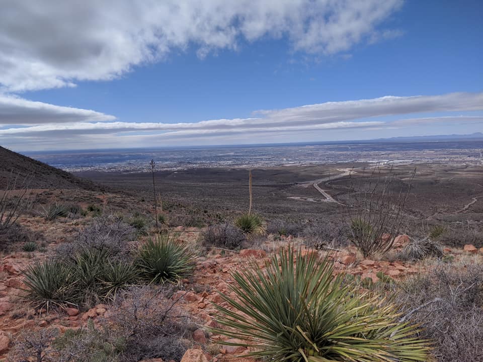
My first stop was along the Upper Sunset Trail.  The trail lives up to its name, with expansive views of the valley to the west.  The trail follows the ridgeline for a mile, making for a nice two-mile exposed hike.  The only trouble is, the sun sets after park closure.  Walking in from the TransMountain Highway is the only option, but there are better options for views.  Just chose a trail that goes higher into the peaks! https://www.theoutbound.com/texas/hiking/hike-the-upper-sunset-trail-at-franklin-mountains-sp

The dogs sniffed around and Minnie seemed very curious about the smells.  But both dogs were offleash at that moment, and I didn't want to fall wrath of any pissed off Texas park ranger.  Minnie was limping anyway, another sign to give her a break and rest in the warm car.  It was only 50F and grey overcast.

I saw a line of people hike up a steep trail a few miles away.  Curious to what trail that was, I drove over to that trailhead.  These people were hiking up the even shorter Aztec Cave Trail, a 0.70-mile rocky path to three holes in the rock.  I wouldn't call them caves, but they did a good job keeping the wind out.  This is a popular trail for both dogs and humans, and all dogs were obediently on leash.  One dog and dog owner I met and chatted to was Johnny and his Malinoi-GSD dog "Bugs."  Bugs was in training for a service dog

Elevation gain is only 400'.  I didn't find this "moderate" rated trail hard at all.  What was annoying were the many large rocks at the start.  These large rocks seem to be at all the trailheads, as if they were blasted from the mountainside and rolled downhill to prevent further erosion. This mountain range was once heavily mined for tin, the only dedicated tin mines in the country, so the many rocks make sense.

Hiking up to the caves took a half hour.  Then I rested in the caves to get away from the wind, and to chat with several others coming up.  People of all ages were coming up this morning, from young children to elderly parents. I rested some more to give the slower people descending some space, and then it was our turn to scramble downhill.  I met Johnny and Bugs going up for a second time.  "I lost one of my gloves!" said Johnny, but his second climb to the caves proved futile; he never found his lost glove.

Minnie was resting comfortably in the back of the Homda, taking up as usual half the area.  That dog loves to stretch out while she sleeps.  I guess stretching out helps her snore louder.  She didn't seem bothered by our absence.

Not wanting to leave the park just yet, I opted for more exploring at the West Cottonwood Trailhead.  This is one hike I did with Sadie back in 2009 and a great summer hike.  From this parking lot one can access multiple trails, including Mundy's Gap and the Tin Mines hike.  The parking lot was getting crowded.  I knew I couldn't hike all the way to Mundy's Gap, that prominent switchback up the mountain.  Instead, I chose the much shorter (and more gentler) Agave Loop trail, a two-mile loop with decent views of the valley.  If the first half mile hadn't been slowed down by the rocks on the trail, this would have been a very enjoyable loop.  the only people I encountered on this loop were rock climbers scaling Sneed's Cory
http://www.rockclimbing.com/routes/North_America/United_States/Texas/West_Texas/Franklin_Mountains_State_Park/

Today's visit to FMSP was only a taste of what the park has to offer.  I could have explored some more, but I also wanted to get more mileage on my drive home.  I will have to come back for a dedicated weekend of hiking to hike the higher, longer trails.  Perhaps I will come back over the three-day MLK weekend in January and bag Franklin Mountain  (7192'), a seven-mile out-and-back trail with expansive views of Juarez (and then finish off a day's hiking at a local brewpub!).

The rest of the day was anticlimactic.  I stopped at the Spotted Dog Brewpub in Las Cruces, 27 miles from the FMSP, and had some very good beers.  This brewpub is one of the three top breweries I probed on this mini-roadtrip.  The other good one was a few miles from the Spotted Dog, the Ice Brewing Company.

http://www.spotteddogbrewery.com/about-us
The Spotted Dog is in an old gas station/garage at 2920 Avenida de Mesilla.  It has a front patio and a side patio, both dog friendly.  It was cold out, 58F, so both dogs rested in the Honda in the back parking lot, under the shade of a large mesquite tree.  I walked in and was immediately impressed with the line-up of wheat beers, ales, and stouts.  All four beers in my flight were well-rounded, and in the end I ordered a Cerveza (5.4% ABV) with my massive chicken grande burrito.  That burrito, served over double-fried fries, is enough for two meals, the server warned me, and she was not joking!  I would rate this meal as one of my top three on this road trip.  Nevermind the endless buckets of peanuts!

I chatted with a local older man, Alan, who stood at the counter the entire time I was there.  He told me some stories about the owners and brewers.  The brewery has been opened since 2014.  One of the first brewers is now brewing for Ice Brewing, another very good brewery three miles away that I visited next.  This brewery has a much bigger and spacious tap room and also offers varied beers.  Both breweries are rated as the top two best breweries in Las Cruces, and I will concur with that rating.  I will definitely be back!

Friday, November 29, 2019

El Paso Mission Trail

It was another cold, foggy morning.  The fog and the oil refinery smoke prevented the sun from rising.  I thought it would be nice to see the sun rise over the Monahans sand dunes, but the sun never appeared  The day simply went from dark grey to light day.  There was thus no reason to linger in the state park.  It officially didn't open until 8:30am but I was out of there at 7:30am.  For three more hours I drove with my winter jacket on, stopping at rest areas and picnic areas to walk around and stretch my legs.


The morning was cold and foggy until I got to just west of Kent, TX, where I-10 and I-20 merge.  The terrain here starts rising and becomes hilly, and that is where the fog finally lifted and the warmth returned.  Finally!  I was also relieved to get out of the Texas stinkhole. I was now officially in West Texas, the Mountain Trail Region of jagged, treeless peaks and arid climate.
https://texasmountaintrail.com/about


My destination for today was El Paso.  I wanted to drive the Mission trail and walk around the compounds, then get into town and explore some brewpubs.  The many short stops and short walks were  fine with Minnie, but she would have tired from longer walks anywhere.

The far western part of Texas is dry and Chihuahuan desert, much like southeastern Arizona.  But unlike Arizona, most of the land is private ranch land, so when there is something public like a rest area, it's aways worthwhile to take a break and take in some history.

The Pyote rest area off I-10 is also a museum to the Rattlesnake bomber than was flown over the area during World War II.  I've been to a few other Texas interstate rest areas that are little museums with free wi-fi.  I took my time to read up on the B-17 bomber.


There is no other trace of the B-17's presence here other than this rest area.  I walked around the place, and walked around two more smaller picnic areas just to take in the desert smells.  How much I appreciate the smell of sage and creosote after spending the night surrounded by sulphuric gasses.


The picnic areas are dominated by truckers who use them as rest stops.  They tend to be trashy and loud.  A few in far west Texas have short trails one can hike to get a better view of the land.

Van Horn, TX is only 80 miles east of El Paso. I drove through the town without stopping to eat, wanting an early start on the Mission trail.  I took a phone call from my cousin Hank who let me know that Carol is back in the hospital again.   She was making progress on losing water weight, but the fluids are coming back.  But more on her later.

There is such a feeling of abandonment and desolation in west Texas.  I got off the interstate at Fabens to drive near the border on TX20. This was once a major route of travel between Mexico and the United States.  TX20 eventually takes one to the missions of Elizario, Soccorro and Ysleta, but there is a lot of old stuff along the way falling in disrepair.  That also includes road kill: skunks, coyotes, dogs and cats.


.


The three missions outside of El Paso are seven miles apart.  All three are still active churches,  I am not a church goer, but I do appreciate churches for the history, however violent it has been in the Americas, This violence has shaped this continent.

Due to the traffic and the many people, I kept the dogs in the car while I walked through all three missions complexes.  Each one is around 0.40 miles around. The congestion of modernity has spoiled the aura of the place. Instead of the gallop of horses and the whines of men, it's now car horns and hydraulic truck brakes.  Trucks and RVs now have to squeeze around the narrow roads as they enter El Paso from the southeast. http://visitelpasomissiontrail.com/explore/missions.html

Each mission is unique architecturally.  San Elizario has steps and a central square, along with an old theatre and soccer field. This is my favorite of the three missons because it is located away from traffic.  The other two are right off busy streets.

Socorro has a plain symmetrical facade

Ysleta has a silver-painted dome. The Tiguans still use this as their primary church.  A Pueblan tribe, they left New Mexico in 1680 after the Pueblan revolt.  This is the smallest church of the three, it also is the oldest (1689) , although its plaza is rather spacious.  The mission is surrounded by busy streets and is within the Tigua Reservation.  I would have enjoyed a quieter place, but then again this is not my place of worship.

I had to let the people enjoy their personal church.  It was early afternoon and now I wanted to try some beer.  The Blazing Tree was the first one to show up on my Google search, a small macrobrewery on the east side of town north of I-10.  Winds were blowing hard now, and dust hazed the air well into Juarez across the border when I walked in, still an hour left of Happy Hour and its $3.50 beers.

The Blazing Tree is worth a visit.  It's a small place.  It's dog friendly, but I kept the dogs resting in the car under shade.  The counter seats ten, and there are three more tables that can seat six each.  The place was already getting crowded with early postwork drinkers.  I sampled a "roasty, dry" pecan porter  (5.3% ABV) that lived up to its name, then joined the exhuberant general manager, Rick, who took willing customers to see the small brewing room.  There wasn't much to that room, but I appreciated Rick's passion for his work.  My beer tender was "Rick II," an older man who knows his beer.  I also tried the top selling Peanut Butter Brown Ale (5% ABV) that is enhanced with peanut oil.


I stayed long enough to try the two beers, then left for a second brewpub in downtown, the El Paso Brewing. It was early evening and the place was still filling up.  I sat at the counter  and tried the Mexican Vienna (!!!) Lager and then a Sun Helles.  I ordered a hamburger but it tasted like a frozen patty thrown on the grill.  Then, when I got the bill, noticed that I was charged 25 cents for a one-ounce sample of the Lager AND that the tip included the taxes!  Tips are always net taxes, so I took offense to the subtle way the establishment wants its customers paid.  Customers are not responsible for tipping on taxes.  The taxes go to the government. The beer and ambiance were fine, but this practice spoiled it for me to come back.

I will say the street the brewpub is on was quiet even at midnight.  In fact, all of downtown was quiet.  The plaza was decorated in holiday lights, but construction on several streets turned me off.  I went straight to a Motel 6 on the West Side of town, in preparation for tomorrow's hike in Franklin State Park.


Thursday, November 28, 2019

Silver Falls rest area, Big Springs

It wasn't a traditional Thanksgiving for me, but I knew that coming out to Texas to see Eric.  It was windy and wet when I got up, but not as stormy as expected.  Looks like the brunt of the rain hit north in Oklahoma.

We met for breakfast at a Denny's near my hotel.  The place was busy!  So was the Whataburger hamburger joint next door to my hotel, and I drove past three more very busy Whataburgers before the day was over for me.  (Whataburger originated in Corpus Christi  in 1950
https://stories.whataburger.com/since-1950 ) We ate our breakfast but didn't talk much; Eric too busy on his phone and I rather anxious about the upcoming drive in the wind.  All I know is that he can't wait to get out of the Air Force so that he can work on his passion, writing.

"Do you have a blog, a portfolio?" I asked him.
"No."
Well, that's a good start...

I dropped him off at the airport by 9:30am and I drove off.  There was nothing else to keep me in Wichita Falls, and a slight sadness overcame me, knowing I'll most likely never come to this town again.  Well, the town has some great restaurants and a very good brewery, so there's something for the wayward traveler, but my time in Wichita Falls has come to an end.

I drove west on US82 toward Lubbock, driving past a few familiar places like the Backporch Taphouse and Sam's Club.  Everything was closed.  Traffic was light, but the wind picked up once I was on the open, flat plains of north Texas and its many (damp) cotton fields and cattle ranches.  My next goal was stopping at the Silver Falls rest area, perhaps one of the nicest rest areas for explorers as it's along White Creek and a waterfall, with stone walls and a picnic area across the creek that encourages people to explore the area.  It's just east of Crosbyton, and the Crosbyton city website lists Silver Falls as a "park." It's worth a stop. The stone walls were built in the 1930s by the Civilian Conservation Corps.  I first discovered this rest area on my first drive to Wichita Falls in 2015.  I always enjoy stopping here with the dogs so that they can enjoy the creek

http://www.cityofcrosbyton.org/site/city/silver-falls-park/


The trail and banks along the creek were very muddy from the rain, but we made it to the falls.  The trail to the falls and back is only a half-mile, as the property all around the rest area is private property.  Minnie dove into the water right away, not even giving me a chance to find a stick to throw to her.  I stopped here with her in mind, though, and this was her chance to get some exercise in.  We were on Minnie Time! I had to be careful not to slip into the creek.


I let the dogs frolic in the water for a half hour, then resumed my drive on US82, past desolate small towns and lots of historical markers.  

There are now over 16,000 historical markers across Texas, according to the Texas Historical Commission's website. I like to stop and read the markers, but sometimes there are multiple markers at one street corner.  Texans think anything that happens in Texas is worth mentioning.  I enjoy reading about battlesites and pioneer settlements, but sometimes a marker designates the location of a building that once stood on the ground but not anymore, or the plaque is about a town founder whose descendants may still be in the area.  No one can argue that nothing happened in Texas.  Its state history is rather colorful (and contentious).


It's a pretty drive on US82 west toward Lubbock, but fog got dense at times.  Roads converged from all directions, then disappeared into the fading horizon.  I enjoy the many stone buildings still standing, and painted advertisements on buildings from long-ago products once sold in those buildings. I never saw one person in any of the towns, even when I got to Lubbock.  I should have driven straight to Big Springs, but instead wasted a good hour looking for an open restaurant.  When I found an open eatery, it was --surprise!-- a Whataburger with a very long line of cars in the drive-through.


Fog got dense again south of Lubbock on US87, now driving south toward I-20.  Flat cotton fields, wind turbines, sheep farms and more cattle dotted the landscape.  I even spotted a flock of cranes resting in a spent cotton field.


The closer I got to I-20, the more the air smelled of oil refineries.  I was now in the Permian Basin, one of the most oil-rich regions in the Lower 48.  Oil derricks and gas burn-offs dominate the horizons, and it's the one area in Texas I don't mind driving through at night because there's nothing scenic here (because of the refineries).  I wanted to get to Big Springs before it got too dark.  The burning gas helps keep the temperatures higher here than the surrounding plains, but the fog also accentuates the smell. Big Springs, TX smells like Whiting, IN!
https://tpwd.texas.gov/state-parks/big-spring/park_history
https://tpwd.texas.gov/state-parks/big-spring/nature


Big Springs was once a Comanche gathering place.  I'm not sure where the springs are now. The one redeeming thing about Big Springs is its state park.  I first discovered this area in 2005 while driving to South Carolina with dog Sara to see my daughter Erin. The park is a three-mile loop drive above a 200' limestone luff dotted with scrub oaks and prickly pear, from which one can see the burning gas from above.   It's a nice deviation from a long drive, although there isn't much else to do here.


I got to the park with just 30 minutes of good day light, and Minnie let me know she was not feeling up to a walk.  I took her back to the car and powerwalked with Zeke to the scenic overlook, then cut across the park via the nature trail.  I managed two miles before it got too dark.  Three other people had the same plan as I do: to walk the road before dark. There is no entrance fee for this small park, but the city still closes the road at sunset.  Luckily the parking lot is outside the gate.

My day was now coming to a close.  And what did I do?  I had my Thanksgiving Day dinner at a Whataburger in town, ordering a chicken sandwich with fries! I was thankful to all the hard-working service personnel working to feed travelers like me. Then I drove another 100 miles west and spent the night in Monahans, just to get away from the stink of Odessa and Midland.


Wednesday, November 27, 2019

Wichita Bluffs

The last mild weather was today, but it was still chilly when I took the dogs to the last section of the Circle Trail I will be finishing while in town, the Wichita Bluffs Nature Area off Loop 11.  This is a totally exposed section along the Wichita River and the Bluffs .  Parking area is right off the road.  This is the most recently-finished section of the Circle Trail.  Homes near the bluff reveal that this is the upscale part of town.

Minnie was feeling stiff this morning, so we took it slowly.  The 10-foot wide concrete path follows the Wichita River for the first half mile, before the trail ascends up the bluffs, with various spurs on the mesa where one can rest on a bench and enjoy the view.  Most of the trees are now naked, but I'm sure in the spring and early fall, views from the top are lovely.  It was too cold today to stop and rest on the benches.

I made sure I stopped at the river to throw a stick for her.  Despite the cold water, she dove right in, totally unphased.  This is what she wanted to do: swim!   The river here is clean and silty, with no visible trash below the water line.

It took us 1:50 hours to walk this section totalling 3.5 miles.  I'm glad I got to do this section of the Circle Trail.  Once the trail here is landscaped with grass along the concrete path, this will be perhaps the nicest section for birding. I'm sure the area pops with wildflowers in the spring, too.  Today the vistas were shades of brown and grey.

Eric and I had a lunch date at 11am and I was only 20 minutes late. It warmed up to 48F by mid day and the dogs were comfortable in the car.  We had a filling lunch at Luigi's right outside the base, where we were waited on by a server-in-training, a nervous young blond named Austin whom I reassured was "doing just fine." We then watched the newest Tom Hanks movie "It's a Beautiful Day in the Neighborhood."   We both thought the movie was just OK.  Hanks plays the iconic children's show host Mr. Fred Rogers, whose kids' show ran from 1968-2001.  (Rogers died of cancer in 2003 at age 74.) The movie is more about the investigative reporter Tom Junod who interviews Rogers in 1998 and how meeting Rogers helped Junod make amends with his difficult father (played by Chris Cooper) who had left the family when the mother was dying of cancer.

I was a little disappointed that Eric didn't want to do anything with the dogs along the river afterwards.  We were both feeling full from the lunch hours ago, so we didn't go out anywhere else for a snack. Granted, it was cold and windy, but even just a few minutes of tossing a stick for Minnie would have made that old dog's day.  He showed no interest in wanting to spend any more time with me, so  I ended up dropping him off back at his guest quarters, then let the dogs out by the Pet Area near the fitness trail and base lodging I was on Monday night.  The sky was now getting overcast and windy, and even I didn't want to do anything else on base.  There is too much construction on base with the main entrance getting modernized and traffic detoured.  Everything I had planned on doing while in town, I managed to do now.  I stopped by Sam's Club to stock up on various Texas beers (I really like the seasonal Shiner "Holiday Cheer," a brown ale blended with nuances of peach and pecans). It was now time to relax in my hotel room while the storm approached northern Texas, and get ready for the holiday and the long drive back to Arizona.  I'm going to miss the warmth and comfort of the hotel room!

Tuesday, November 26, 2019

Exploring Wichita Falls and the Circle Trail

Today was Eric's last day in school.  I didn't want to be in his way and made this a day of solo exploration with the dogs along sections of the Circle Trail . Weather was in the mid 60s and breezy.  The trees in the historic old town were still dropping their leaves.

The downtown has seen a revitalization since my last visit here in 2015. Modern restaurants, two coffee shops and a few good diners and a brewery are all new, bringing customers to this forgotten part of WF.  After a quick walk in the small historic section, and a stop for a cup of pumpkin latte at the Odd Duck coffee shop, we started our walk at 10:24am at the convention center.  A small ten-lot parking lot for trail users is right here.

I continued walking the Circle Trail from where I left off yesterday, just past the mile marker and the waterfall to Williams Park by the water sanitation center. The Circle Trail here follows the Wichita River, but here the river is badly trashed, with styrofoam, beer bottles and cans and plastics along the shore.  It also smells of affluent. The floodline from earlier this past May is still visible.  A lot of dog owners also don't clean up after their dogs. It's a shame, as this is a shaded part, with old sandstone bridges ferrying traffic above.  Families with strollers, joggers, and a few cyclists passed me on this route.  Whenever there was a s break in the treeline, I'd take the dogs down to the water.  Minnie looked forward to every dip in the river I granted her.  She had a blast.  Zeke just stayed on the banks and pretended to want to play fetch.

My cellphone died after only a half-mile, so I didn't get to record the best part of the walk.  The first four miles of the Circle Trail is through the poorest part of town (evident only when I drove the streets parallel to the trail to record the distance).  Minnie slowed me down quite a bit, but the fact that she did a good five miles today shows her dedication.  The river motivated her!  We turned around at the gazebo just before the water sanitation center, then walked back the way we came.  The Circle trail moves away from the Wichita River and continues through Williams Park for a mile, before it resumes its river course along the dredged canal, Holliday Creek, on the southeast side of town.  This section is now totally exposed.

Zeke and I walked 2.4 miles here by ourselves, leaving Minnie to rest in the car.  The cool breeze and overcast sky were ideal for a break.  It looked like rain, but it held out long enough for Zeke and me to get a few more miles in before I took a beer break at the Wichita Brewing company in downtown.  The place doesn't open until 3pm and I timed our arrival just right.

I was quite surprised by this brewery.  It's very nice inside and offers plenty of beer on tap! Only service dogs are allowed inside, but the dogs were tired and appreciated a rest while I sampled some of the wheats.    I appreciate brewers that brew more than just IPAs or sours. The brick building is an old corner department store, with plenty of space inside. The line-up the brewery has, both of flagship and seasonal beers, (even a few "experimentals") is impressive.  I sat at the counter and asked one of the beer tenders, Eric, lots of questions.  It wasn't very busy but I gave him plenty to do. 

With waning light now engulfing me, I drove around the southwestern part of town along US277 and Kemp Boulevard, where the Sikes Senter Mall is and many more eateries.  Eric and I were in the mall last time, but this time I avoided it. I noticed more chirping blackbirds in the trees.  What is up with blackbirds and Texas? I finished dinner at Heff's Burgers, another Texas franchise, and tapped the evening off with two more miles along the Circle Trail just east of the Lake Wichita Park.  I took Minnie on this stretch again, walking the breezy spillway in the dark, but with no one else around.   I'm glad of that, as I had the dogs off leash here.  I had done seven miles along the nicer sections of the Circle Trail by the time I was done for the day.  I avoided the sections that veer away from any water.  It was an exhausting day for the dogs, but without this Circle Trail in town to explore, I would have been bored and probably would have sat in a brewery and had more beer instead. I can do that at home!

The Circle Trail will be 24 miles once it's completed, but articles I found online say the locals are against funding any more sections.  What a shame, as people need an excuse to get out and exercise.  I sure took advantage of what I could of the trail while in town, and got to see the city a bit more intimately.  I wouldn't have brought Minnie on this road trip had the river not been available.

http://www.wichitafallstx.gov/864/Maps
http://www.wichitafallstx.gov/86/Circle-Trail?nid=86

Monday, November 25, 2019

Wichita Falls' Lucy Park

I pushed myself to make it to Wichita Falls (WF) within 24 hours of leaving the house.  I saw the sun rise over a flat horizon south of the cow town of Rody.  I was too exhausted to sleep and stayed awake with morning traffic once I got into WF.

WF is a town of many road mergings and it all confuses me.  Once a railroad town, it's now home to Sheppard Air Force Base. US Highways 277, 281 intersect in town.  I-44 ends here.  There are many access roads to these main roads.  Even though this is my third time in WF, I still get confused without reliable GPS.  Driving in and around torn require one's complete attention.

I stopped at a McD's for breakfast.  I tried the biscuits and gravy and it was pretty good!  Each dog got a sausage biscuit as well to hold them over.  I stopped at a Sam's Club briefly, then headed out to Lucy Park, and even that is confusing to get to.  I had been here before with Eric and the dogs, just to get some exercise in.  It's a spacious 178-acre park with picnic tables, disc golf,  and a 10-foot-wide concrete path. http://www.wichitafallstx.gov/69/Lucy-Park

The park is centrally located and borders the Wichita River.  It's within walking distance from the historic part of town. A five-mile loop starts and ends here, following the river.  The rest of the completed Circle Trail loop around the inner city.  Twenty-two of the 24 miles are completed. I hope to do the entire loop while I am here, but will have to break it down into several days for Minnie's sake.  Its many oaks and maples provide for shade, at least here in Lucy Park.  Many other sections of the Circle Trail are exposed and away from any water.  I will skip those parts.

The park was busy for a Monday.  I walked the dogs to the falls after which the town was named.  The current 54-foot waterfall is man-made.from 1989. The original falls were destroyed in a massive flood in the 19th century and are a half-mile away .  The falls look nice when the water is running, but when the water is turned off as it was the last time I was here visiting Eric, it is rater boring as then the water pipes become obvious.


We managed 2.6 miles out and back on the trail, with plenty of stops to throw sticks in the river.  This took me two hours and I still had plenty of time before Eric was free to meet up with me.  (The class he is attending ends at 4pm)  I checked out the Backporch Taphouse (good beer selection, but far too expensive; a pint goes for $7.50!) and my server there recommended the Half Pint Taproom in downtown, and that is where Eric and I had our dinner at 7pm.  I only had one beer, but the big disappointment was the brickoven pizza which many reviews raved about.  The crust was too thin, soggy and greasy, but the ambiance was nice.  The Half Pint Taproom is a nice place to meet up with friends and chat by a fire pit, or inside on couches.

We didn't spend much time together as he has one more early class tomorrow.   He seemed preoccupied and wouldn't talk much.  All I know is that he has just under two more years left in the Air Force and wants to get out.  "Everyone is bitching about it [the duty]" he explained, without further detail.

I dropped him off at his lodging at 8:30pm, then walked the dogs one more time for 2.5 miles on the nearby Wind Creek fitness/disc golf trail on base.  There was no moon and thus dark, perhaps the only way I can get away with walking the dogs at night.    We finished off with the sounds of Taps playing at 10pm before returning to the hotel.

Sunday, November 24, 2019

Road trip to Wichita Falls, TX

Did a walk with all four dogs at sunrise.  Sadie and Sweetie won't get walked for a week now.  I'm just minutes from leaving for the 850-mile drive to Wichita Falls. (WF)   Zeke and Minnie are going with me.

I have good weather for the drive there.  Rain isn't forecasted for Arizona and Texas until Wednesday.  We'll have a wet Thanksgiving Day again, just like in 2015 when I last drove to WF to see Eric when he was last in WF for his initial HVAC training.

I love road trips, but I hate the leaving part.  I tend to delay my departure by cleaning the kitchen.  Well, enough cleaning.  Zeke and Minnie are patiently waiting for me in the Honda.

I finally drove off at 10:05, just as NPR news finished up.  I drove along the border, taking AZ80 from Bisbee east to Douglas and into New Mexico, then taking NM9 across the state to ElPaso.  This stretch of treeless low-elevation mountains and open cattle range is heavily patrolled by the US Border Patrol

I made it to ElPaso at 3pm, but then heavy traffic slowed me down.  A detour along the Mission Trail came too late, as the setting sun was threatening darkness before I had a chance to see the last mission, the Elizario chapel and its many chirping blackbirds in the plaza.  I will have to come back when there's more light.

My first big meal came in Van Horn, a lonely cattle town off I-10.  This town has seen better days, with several older buildings now bordered up and listed for sale.  Fifteen years ago, when Kevin and I first drove through town on our way to Arizona, we chatted with a very passionate anti-Busher who ran the Trading Post.  He basically owned a junk shop.  That shop is now for sale and has been for sale for several years.  The town's one famous landmark is the family-owned Chuy's Restaurant.

Chuy's Restaurant was made famous by Oakland Raiders coach and then sports announcer John Madden, who drove in a bus (his "Madden Cruiser") instead of flying to his games.  Chuy's allegedly was one of his favorite restaurants and he became friends with the family after his first stop in 1987 .  A padded wooden chair still bears his name, and 1980s newspaper articles and black-white photos of Raider players and NFL team banners adorn the walls.  I must admit the decor is quite unusual for a Mexican restaurant.  Instead of loud mariachi music, this place plays sports on their one wall TV. A "John Madden special" (chicken picado) of chicken breast and seasoned rice is still on the menu, but I had the more simpler flat chicken enchiladas with green chili.  That filled the spot!  I was the only customer when I walked in at 7:30pm and no one else came in while I ate.  My server told me that a large group had just left.  Opening hours are until 10pm on Sunday, which seems late for a small town, and the server was cleaning up as if she was closing for the night.  This was a very enjoyable meal, and it beats a warmed-over burrito at the Love's truck stop nearby.

https://thetexasbucketlist.com/2017/09/the-texas-bucket-list-chuys-madden-haul-of-fame-in-van-horn/

I drove through the oil refinery towns of the Permian Basin late at night, getting through Midland and Odessa as fast as I could.  I normally prefer daytime driving, but the smells of these towns gives me headaches.  It's like being back in Northwest Indiana's steel mills and refineries off Lake Michigan.  I never stopped for the night.  Instead, I'd pull over for 30 minutes to rest while listening to my latest audio book "Edison" by Edmund Morris, his last great book before he died this past March.   The bluetooth connection between my phone and the Honda's speakers works very well.  I never did listen to local news once I got to Wichita Falls.   I listened to so much of the audio book, that I accidentally shut down the car battery three times!  This is why I never road trip without a battery charger.

Friday, November 22, 2019

Cold morning

I took another sunrise walk with the dogs.  There were still clouds shrouding the mountains at dawn,  thus filtering out the first sun rays, making it look as if sideways beams were bouncing off of San Jose peak.  It was a mere 39F at the 6:56am sunrise, and my hands were cold!


The cold didn't seem to bother the dogs, though.  Minnie, especially, frolicked along.  We made it to the ruins  and back for a brisk 1.85 miles.  The reservoir didn't get filled with water, but the dogs ran down to it to inspect it.  They came back muddy, so that is a good sign.

The sun never lighted up the Huachucas, but I could see the snow above 65oo'.  Fog lay low in the foothills and along the river.


I enjoyed watching the clouds play with the light.  While the colors weren't dramatic, the lighting sure was.  When it was all over, the peaks cleared and the snow revealed itself.  I should try to get up there tomorrow before I head out to Wichita Falls on Sunday.


I treated Kevin to a filling breakfast at the nearby Chuckwagon Restaurant.  The building had been vacant for a few years before the Maudlin family bought it and opened it up again this past April.  It's run by the entire family, with brothers waiting tables, a nephew cooking, and a few nieces also waiting tables.  JR was our waiter today, a jolly, big-bellied and Stetson-studded man in suspenders. His brother Bobby was in the kitchen, and that prompted me to comment about the Ewing clan of the Dallas TV show of the 1980s.  "I'm the original JR!" replied JR.  He grabbed a chair to sit down with us while taking our order.  "I got two bad knees!" he explained.

One of my favorite breakfasts is Biscuits and Gravy (because it's so filling) and the order with a side of homefries filled me up just right.  Kevin had his two eggs over medium, bacon, and sourdough toast and said the eggs were perfect.

Clouds had gotten thicker and lower over the mountains in that time, almost shrouding the range entirely.  My hands and feet had been cold all day, so I decided not to venture up Carr Reef.  I took the dogs down the river again to check on its flow.  The entire pack came along.

I was quite surprised to see the river flowing normally again.  Gone was the muddy flow from yesterday.  All four dogs ran down to the water to splash around.  The only difference today is that the river smelled clean again.  Gone was the stagnant, boggy smell from before the storm.  I let Minnie get her aquatics in for a bit before completing another 2.25 miles around the field.  It was a very calm time along the water.  There weren't as many birds this time, but it was mild (53F) and windless. The flooded horse fields from yesterday are also drying up slowly.  Life is returning to normal.