By late Friday afternoon, I had arrived at Organ Pipe Cactus National Monument with Sadie and Zeke. It was a near five-hour drive to far central-south Arizona, a region I had never been to before. AZ86 and then AZ85 were the two main roads, taking AZ86 from I-19 just south of Tucson and through the Tohono O'odham reservation. It's a two-lane shoulderless road for the entire distance, interrupted frequently with cracked pavement. The park shares 32 miles of international border with Mexico. Route 2 in Mexico straddles the border. A lot of truck traffic passes through. AZ85, which bisects the park, is also a major route for American tourists on their way to Puerto Penasco, or Rocky Point, another place I've never been.
For two days I hiked, drove around, walked the dogs and then chilled both nights at the Twin Peaks Campground near the Kris Eggle Visitor center. I came with no distinctive plans but to "explore." Eggle was a park ranger who was killed August 9th, 2002 by drug runners in the park. The park was known as one of the most dangerous national parks because of the drug and human smuggling activity at the time. Its proximity to the border allows illegal activity to continue. This is why I had never been there. I took advantage of the current no-fee national park policy right now, implemented by Director of the Interior David Bernhardt, to encourage people to "social distance" safely during the coronavirus outbreak, in any of the national parks. The National Parks Service has not stated how long this no-fee policy will last.
https://thehill.com/policy/energy-environment/488281-national-park-service-waives-entrance-fees-during-coronavirus
I really lucked out with this park and the weather both days. I had mostly sunny skies and a breeze on Saturday and cloudy skies Friday and Sunday. I was also lucky to get a spot in the campsite both nights, as the park service has switched to a reservation system and you must reserve at least 24 hours in advance. January through March are the busiest times in this park. I had no reservations and was a drive-up so I took what was open for the taking. (Reserved spots were noted by the entrance kiosk by name and site number, which was unmanned when I drove up Friday night.)
I didn't know what to expect once I got to the park. Would there be too many snowbirds taking over the campsite? (No). Would there be any nice trails to hike? (Yes!). Would it get too hot for the dogs who must stay in the car because dogs are not allowed on the trails except the campground perimeter trail? (No). I had thought about Sedona all week and then ended up here! Life is full of surprises.
I had two full days of activities. And while I did not see everything, most of that had to do with the southern part of the park being closed for border wall construction. There was A LOT of that along the border.
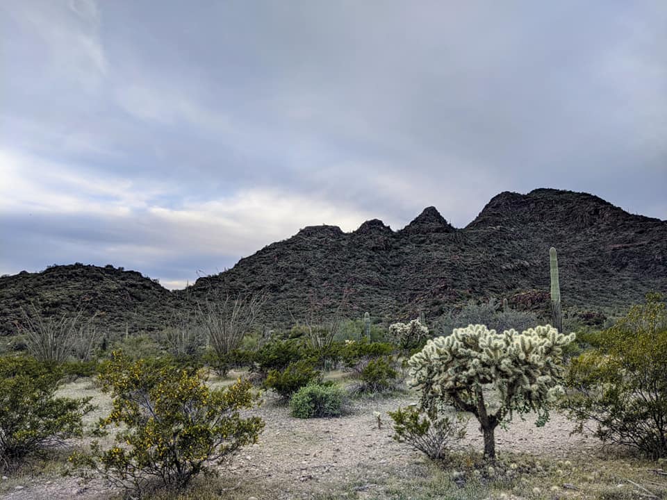
The park is divided into two main mountain ranges, the northern and central Puerto Blanco range where all the mining took place, and the taller and craggier Ajo range on the western side. Neither range has any running streams. This is the only region in the United States where the Organ Pipe Cactus grows. Thus the park name. But so much else grows here besides that cactus.
My first stop once in the park was along the North Puerto Blanco Road to Pinkley Peak. The sky was overcast and it was beginning to get chilly. My first impression of the park was not so much the Organ Pipe Cacti, but at how many saguaros there are here. Yes, there are organ pipe cacti, but saguaros dominate, along with creosote, cholla, palo verde trees, ocotillo, sage and white ratany (a shrub that pioneers used to brew tea). The hillsides are mostly rhyolite or volcanic rock, and there's plenty of ore in the ground from the silver mining days.

I walked the dogs on the dog-friendly Twin Peaks campground perimeter trail that first night, a 1.2-mile loop with views toward the Sensia valley to the south. At night the border lights from the Lukeville border station five miles to the south shone, but otherwise it was quiet. There were plenty of unoccupied campsites, too. Were people afraid to travel because of the coronavirus? Those who were there, from young families to young adults and the silver-hair crowd, all kept to themselves at their camps sites.

Saturday was my busy day. I got up before sunrise and hiked toward the Victoria Mine near the campsite. It was in the upper 40s and I was chilled, making me walk fast. I didn't quite make it all the way because of the dogs (didn't want them alone in the car for too long), but I did get a good impression of the area. This is a 4.4-mile r/t hike. I only made it 3.5 miles. The campsite is near a large mining complex that once mined for silver. One could create an eight-mile loop hike here. The trail to Victoria mine is relatively flat and traverses through fragrant creosote and all the other flora of the area. The sunrise on Saturday was beautiful. A dense mist lingered at the base of the mountains, and that mist dissipated when the sun rose. As soon as I got back to the dogs, we took off for the drive to Quitobaquito pond, a small pond right on the border.

There is a lot of border wall construction right now. The old metal picket fence is only to deter vehicles. People are able to jump over that easily, and according to park rangers, a taller wall here is much needed. I do agree with that. But why so tall, and why clear so much vegetation?


Quitobaquito Pond is on the far southwestern part of the park. It's not very big at all, but the trees and water appear like an oasis in an otherwise arid surroundings. Water fowl like egrets and mallards call this pond home. Susan had mentioned it, so I had to see it. The walk to and around the pond was a mere 0.4 miles, so I added to that walk by taking the dogs on a one-mile walk on the road. That wasn't a smart idea, because shortly after I got to the pond, the convoy of construction vehicles (lots of water trucks) came barreling by.


I wanted to drive the Ajo Mountain Road in the afternoon. After the short visit to the pond, I stopped at the Sensita Basin mining complex where I did a quick walk to the Miltion Mine (1.6 one-way) and later the Sensita Basin Loop, a flattish triangle. The basin is in the middle of all the mines in the area: Milton, Baker, Victoria and an easy leg stretcher. It was still mild and breezy and the dogs were shaded. Sadie didn't mind waiting for me in the car.


I saw few people on the mine trails. I discovered later that most people, especially the younger ones, head out to the Ajo range and hike either the Arch Canyon trail (1.6 mile), or the Estes Bull Ranch trail (3.2) This is a shame, as one can create longer hikes around the old mining complex and see some history.

I had now spent all morning near the South Puerto Blanco Road area. I was glad to get away from the border road and the chaos there.
All visitor centers in the national parks are temporary closed during this coronavirus pandemic, but they are still manned by rangers who stand outside at a distance. Rangers had a small display of pamphlets outside the building and gladly took questions. They were a friendly bunch, despite dealing with that afternoon sun. And to my surprise, there was wifi available in and around the building! That's a first for a national park. (One ranger told me it's because they cater to so many snowbirds who camp at the campground for two weeks at a time). I filled up my water and then took off for the Ajo Mountain Road drive, a 21-mile loop that takes at least three hours. I'm so glad I added this to my activities, as here is where the wildflowers came to prominence, although nothing like the display I had two years ago outside Joshua Tree National Park.
The drive starts with a gentle grade that meanders around the mountains. No water was flowing anywhere, but flowers were popping up here that I hadn't seen elsewhere in the park.


There are a few rest areas along the way to pull over, but the big prize along the drive is in Arch's Canyon and the Estes Bull Ranch trails, more than half way through the drive,


Here one can climb into the mountains and even stand on an arch, although the trail to the top eluded me. This also had the most cars in the parking area, and lots of people of all ages on the trail. I turned around near the end and was surprised by a pissy rattler, my first one for the season. If I had known that the Ajo range was full of nice vistas, I would have skipped the mine trails and gone to this area earlier in the day. I had no energy for the Estes Bull Ranch trail. I had already hiked a cumulative nine miles by then and I was losing energy. I could easily spend an entire day exploring the Ajo range.
I returned to the visitor's center, again filled up with water and washed up, and watched two smokey grey Phainopepla flit around the building. These birds are native to this region and to Mexico.

I stayed at the center just long enough to read email, post on Facebook (but I avoided the news) and then returned to the campsite to hike the Desert View trail, a 1.5-mile loop with a view from a hill nearby. This trail is also accessible from the campsite. I was the last one on the trail before dark. Sunset was colorful again.

My big meal of the day was chicken alfredo, a dish Kevin got for me from Applebee's. All the food I had while in the park was brought from home, so my expenses were minimal. The only inconvenience was getting stared at by the dogs while eating the meal. The dogs ended up getting the chicken breast while I got all the pasta. It was a fair deal.

I took advantage of the solar-powered shower Saturday night. The water never got warm, but it felt so good to be clean for a while. I was very impressed with the camp's cleanliness. I occupied #179, one of a few more unclaimed spots for the night. It was another quiet night. I had done so much hiking today, that I slept soundly. And this time Sadie let me sleep in my spot.
It takes two, three days to see and do everything worth seeing in the park. The southeastern part of the park is closed due to the wall construction so that eliminates some of the historic ranches. I had to cut a few hikes short because I didn't want the dogs in the car for more than two hours at a time. If there is one regret, it's that I couldn't get to Dripping Springs, the only natural water source in the park. It's on the north end of the park on the North Puerto Blanco dirt road that the sign says requires high clearance. My Honda is not a high-clearance vehicle. What I did do though is get up early Sunday to walk the dogs along the North Puerto Blanco road, the first spot I went to Friday afternoon. It was chilly at first, but it warmed up into the 60s when we got done with the four-mile walk 90 minutes later. I only saw one other driver in the area.

This northern section doesn't seem to get as many visitors as the Ajo range does. One lone runner, a woman training for a marathon, ran out and back while I was out walking. I do miss being able to run.


The dogs got four miles in. They are allowed to walk on any of the roads in the park. Sadie seems to be tired of these walks; she initially didn't want to get out of the Honda, but she did well in the end and I rewarded them both with treats once I got back to Tucson Sunday afternoon. The four miles also calmed them down, as both dogs napped peacefully the rest of the day.

My last hurrah in the park was a quick 1.6-mile r/t to the Red Tank Tinaja, a rock depression near the mining complex that I'm sure was used for water for the mines. It was a flat, fast hike on an old mining road that I finished off at a water station set up by the Humane Borders Alliance, volunteers who drive around the border filling up water tanks for border crossers. I drove past at least three such water stations. They are marked by blue flags and blue tanks.


And with that my adventure at the park was over. I got to do a little bit of everything here, from watch birds, photograph flowers, walk around a few mines, and hike up hillsides. It was time to head back home. At 10am I headed north and existed the park to spend a few hours in Ajo, AZ. This was my first visit there.
https://www.nationalparkstraveler.org/2020/02/border-patrol-turns-explosives-build-wall-organ-pipe-cactus-national-monument
No comments:
Post a Comment