The alarm got us up at 5:05. By 5:20am we were on our way to the trailhead, which turned out to be 150 miles away.
I didn't hit congested traffic until I got on CA210. I made it to Azusa, the trailhead town, at 7:15 and stopped at a Mexican bakery for coffee and a small cake. A heavy marine layer fogged out the peaks. I remember that marine layer all too well while living in Pacific Grove, CA from 1996-2000.
It was the only place open that was on the route. The route was the scenic San Gabriel Canyon Road. My one dilemma was the ranger station was closed but I lucked out getting a $5 Day Pass from a maintenance man at the Camp Williams Cafe. He opened the cafe for me to allow me to buy a pass. I could now park legally at the trailhead.
There were a few cars in the lot, but no one else on the trail. I saw anglers in and near the water, a few abandoned sites, but the trail itself was barren. At 9:20am we were on the trail, with partly cloudy skies and cool. A perfect day for a hike. This is a long hike but not a strenuous hike as the elevation gain is minimal.
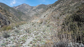
The trail follows the East Fork of the San Gabriel River, along the old road that Nature has reclaimed. The road was built in 1936 but two years later a massive flood took out the road a mile south of the bridge and it was never rebuilt. Parts of the road are still visible in parts, but it's mostly a double track trail now, lined with plenty of agave. According to one man I met on the trail, more flooding occured last winter and now hikers have to walk the riverbed; after heavy rain I would not want to be on this trail.
d
The trail is not marked, although I did see a 3 and a 4-mile marker post. It was slow going at first because I stayed close to the river for the dogs' sake, but the trail is mostly on the right bank and high. (I discovered that on the return trail). There are five river crossings. The water never got too high for me to use poles.
It took me 2.5 hours to reach the old bridge. It's still standing, although it leans noticeably. We made it down to the river and had a lunch. I munched on tangerines and the dogs each had a can of food. I enjoyed watching them frolic in the water. It was at the bridge where I chatted briefly with two couples, but otherwise I was alone with the dogs and the sound of rushing water.
The hike out and back came to 10.4 miles and took me 5:55 hours. We were all tired when we got back to the van. I sat behind the wheel and drank two teas. I didn't want to leave the mountains just yet.
I drove into Los Angeles after the hike, taking I-10 and using my Waze app to find the trailhead for the Runyan Canyon Park off North Fuller Avenue. This park is lauded as one of the largest dog parks in the country. While I had to have the dogs on leash while walking to the park, once inside and past the "off leash area," both dogs were happily off leash. Big and little dogs were running around. I don't worry about Zeke, but Sadie can get aggressive around small dogs.
There were people, kids and dogs everywhere! The main trails goes up and around a long ridgeline, but after the 10-miler I was a little too tired for another 3.3-mile walk. I could see a line of people on the high western ridge. I took the East Ridge Trail that took me high enough, with a view over the city and the Hollywood sign. The overcast skies made this walk enjoyable, but the exposure on a hot day would be harsh on a dog. There are water fountains now for dogs and people. I would definitely come back to this park on my next LA visit.
More later; I'll add details later this week.


No comments:
Post a Comment