I like stopping in Joplin. The town has every big restaurant chain and plenty of local diners to chose from. It also has a pretty section of Route 66. But today I just stopped at McDonald's because I like their cappuccinos. I had plenty of leftovers from my time in IN to consume for the rest of the day.
It was considerably colder in the morning. Winter was back. The drive-through lane at McDonald's snaked around the building. I needed my lowfat milk cappuccino flavored with hazelnut syrup. NPR news talked about the assassination by drone of Iranian QUDS military commander Quassim Sulaimi, commander of the elite Quds forces and mastermind of recent terrorist attacks in Syria and Iraq. While he did focus on ISIS troops, Trump said he needed to be dealt with because he was planning a big attack on American forces. Killing him, said Trump, saved American lives. I'm normally a news hound and can listen to NPR all day long. After hearing this news, I opted to resume listening to audio books. My choice today was David McCullough's "Truman."
My plan for today was to tour eastern Oklahoma's Route 66 and to hike around Turkey Mountain in Tulsa, an urban park I discovered in July. Driving on the designated Route 66 also takes one off the Tollroad on I-44, perhaps one of the worst tollroads besides New Jersey's Turnpike. Tolls don't seem to go toward maintaining either highway.
What Oklahoma lacks in beauty it more than makes up in roadside attractions. Its 374 miles of Route 66 is the longest stretch of intact Route 66 of any of the eight states it travels through. I wanted to see parts of that route that I hadn't seen in previous drives through. Most of the attractions are of old gas stations and old gas pumps that remain as living museums, but there are also old man-made attractions that were meant to lure people in cars to get to them and spend money. Most of the road between towns is now frontage road off I-40, and Oklahoma has the longest stretch of intact Route 66. Some sections are worthwhile. A few have fallen along the roadside, some get modernized, and a few are worthy of a stop to enjoy and walk around.
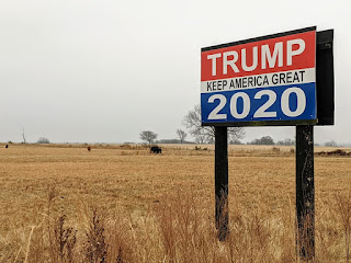
Route 66 originally was nine feet wide, just large enough for a car of the 1920s. This old section outside of Affton was completed in 1922. It is now known as the "Ribbon Road" or "Sidewalk Highway" as only cars can traverse it now safely. The marker stands off the road facing US 59/69 north of Miami, OK. The road is now a little-used farm road. Two large Trump signs are a few miles south of that marker on the busier highway. I'm sure the cows are pleased. By now it was light enough to see detail.
Traffic on US 59/69 was now picking up. My first stop was in Miami to see the new Mural park. Party lights hung across the walls made the bright colors even stronger. Stores were still closed and parking was plentiful on a back road. Zeke and I took a brief (and very chilly!) walk around the block. The bright mural stands out among the much older buildings. I' sure the public area once was the location of a building that got demolished, as it's now a walk-through area to the public parking lot. There are other murals in Miami, but this one depicting a masked dog, stands out. It was this mural that made me stop in town.
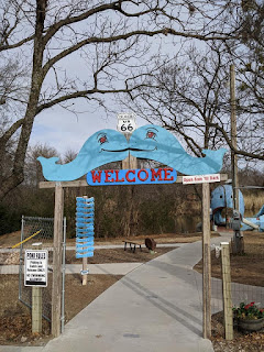
I still had 88 miles to go to reach Tulsa and traffic was building up. I was looking for the Blue Whale of Catoosa, a giant cement structure I saw on my last drive through the area but didn't explore because it was still too dark. This giant blue whale was built in the 1970s by a local man for his grandkids to play in, so it's not part of the original Route 66 history, but like many roadside oddities along the way in Oklahoma, has become a roadside attraction. It was 8:33a when I stopped here, walked a short trail that began by the whale and then went into the woods, but then realized it ended on private property. This was a short 0.6-mile leg stretcher, and I can see why people would want to stop here to grab a bite to eat at the snack shop (that wasn't open yet) and relax by the pond while resting at a picnic table before resuming the drive across the state.
I enjoyed the short walk with Zeke, but noted how trashed the woods were. I saw trash all along my route today: plastic bottles, plastic wrappers, beer cans and bottles.
My next stop was Turkey Mountain Urban Park in Tulsa. I discovered this park on my last drive through the state, but got there in the early evening and only walked part of the paved trail. My experience during my first visit here was a positive one and wanted to experience the park during the day. There is ample parking here and Tulsa police do patrol the area.
I got to the main parking area off S Ellwood Avenue I was at back in July and took the first dirt trail heading north. This was the trailhead of the Blue and Yellow trails. The Yellow trail is marked at 3,7 miles long, the Blue trail a mere 1.4 miles. I wanted the longer distance by hiking the 5.7-mile long Pink Trail, but ended up doing a variation of the Yellow trail when I realized both trails were crowded with groups of people. The Pink trail is a half-mile farther north off Ellwood Avenue. There are also many unmarked trails on this hill, so I got off the Yellow trail and got back on the paved trail that followed the Arkansas river. This trail is part of the River Parks Authority of Tulsa and goes into downtown Tulsa. I will explore this section on my next drive.
The Arkansas river looked like it was drying up. It was flowing much stronger in July. Sand banks were visible in parts of the river. The paved trail was busy with joggers and cyclists and went past a waste water treatment facility before going under I-44 into town. This is where I got off the trail, found an unmarked trail that took me back up Turkey mountain, and resumed my hike on the Yellow Trail.
The Yellow Trail is popular with mountain bikers. The eastern part of the trail follows a ridgeline along the mountain, with views of the river, before it turns sharply back south. Many more unmarked trails traverse the marked trail, allowing me to get off the trail to make way for the mountain bikers and others walking with the dogs.
We ended hiking 4.5 miles here, a decent distance on a road trip, and spent almost two hours in the park. I enjoyed the park and would stop by here again. There are so few options for hikers in Oklahoma along the Route 66 corridor, but this park deserves its merit. Maybe next time I'll actually go into downtown Tulsa. It was now noon, and my lunch was left over deepdish pizza I had taken with me from Indiana. My next goal was Amarillo, 365 miles away and traffic was getting denser.
I was now less interested in Route 66 things, although there are some nice dinners around the OKC area, such as Weatherford, El Reno and Elk City, but I'v been to the attractions there. It was after 3pm when I got to the west side of OKC, getting stuck in traffic as I got on I-40. I got to Amaraillo at 8:30pm, too tired for anything to do and just settled down for the night. I didn't even stop in a brewpub.


No comments:
Post a Comment