I take my cans to Desert Metal Recycling in Tucson, but that's in the center-south of town, 20 miles west of the Catalina Highway. (I got $15.43 for the cans and two iron roters) There has to be a closer place on the east side of town, where the best hiking trails are.
Weather was in the 60s with overcast skies. I was still dressed for alpine mountain trekking with three tops and two bottoms; clearly overkill for the milder weather in Tucson.

We stopped first at Agua Caliente Regional Park on the east side, off Snyder Avenue in a foothills neighborhood. I had heard some nice things about the place from Chuck the hiking photographer, but outside of the California palms along a natural pond, there's not many hiking options there. There is a mile-long paved trail that takes one out to two retentions ponds. All the natural trails that lead one into the neighborhoods are closed off for rehabilitation, with no trespassing signs posted. This is to keep hikers from wandering around the upscale neighborhood. (It has nothing to do with rehabilitation efforts because it's all cholla, mesquite, and palo verde trees that grow abundantly in the low desert around Tucson). Outside of the water fowl around the pond, and the impressive mature mesquite trees with their gnarled branches, there isn't much else to enjoy here. The park is developed, with a large parking area, flush toilets and water fountains, and nice for a day picnic for a casual walk with children or the elderly, but it's not enough for me who needs to be physically challenged. At least I got to see the little park for once.


I then suggested driving up the Catalina Highway to hike a low-elevation trail. There are many trails off this road that I still haven't hiked. Steve had never been up there (!!!) and I have been wanting to explore the Prison Camp area (the Gordon Hirabayashi Recreation area), where prisoners building the Catalina highway were housed in the 1930s and where the US government interned Japanese-American citizens during WWII. Nothing remains of the camp besides a few stone walls, but there are several historical signs explaining the history of the camp, so it's not entirely wiped out of our regional history. The Hirabayashi story is quite embarrassing now, but it happened and the incident should be a reminder of our (racist) unjust policies toward the Japanese during the war. I'm sure if the Japanese-Americans had brewed as much beer as the German-Americans did here in the late 1930s and early 1940s, we would not have forced them all into prison camps. But I digress...
This was the first time I have stopped at the Hirabayashi rec area. I always see cars parked here as I continue my drive up the mountain for more higher-elevation trails. Now I finally take some time to explore this lower elevation trail that is popular with the locals. Once we parked the Honda and began the trail, we discovered why it's so popular: the scenery is beautiful! I regretted spending time at the Agua Caliente park when we could have had more time exploring this trail. We didn't get started until 2:50pm, allowing us just two good hours of daylight. The trail to the reservoir follows a natural drainage on a wide, sandy surface. The grade is very easy for most hikers. There are cement foundations where once buildings stood along the trail, adding to the mystery of the past.

We were on the Arizona Trail going northwest, with a starting elevation of 4977' (according to my GPS app), following signs to the Sycamore Reservoir two miles downhill. That sounded like a doable distance, and it is when there's time, but once we hiked up the wide trail to the Shreve Saddle at 4941' and saw the descent down into Bear Canyon to where the reservoir is, we opted to turn around. We didn't have enough natural daylight to do this hike safely. It would get cold once the sun dipped behind the mountains.


We made Shreve Saddle our resting point and turn-around, sitting on an old cement foundation looking out toward the canyon. We could see the trail descend downhill, along the craggy hills around it. A gate at the saddle closed off traffic to "rubber-tired vehicles" on an abandoned road going down to the reservoir, but this abandoned road is clearly still used by hikers who want to explore off trail, and something I would do. Next time I come here, I'll hike this trail down to the reservoir, and take the official trail going back uphill.

The reservoir was used to supply water to the old prison camp, but all that's left now is a dry drainage ditch with a few rusted metal pieces scattered in the overgrown ditch. What had this place looked like in its heyday? We were the only people around and the dogs enjoyed their freedom to explore. Trace did the frantic exploring while Zeke walked behind me smelling my body odor.

The sun was now beginning its descent. A golden hue wrapped the peaks around us, telling me we didn't have much daylight if we were to stay at the saddle. We hiked back to the parking area, walked around the ruins of the camp, read the history of the place, and then began the drive down the mountain. A lone camper is all that remained in the campground as we drove off.


Traffic on the road was steady. People were coming uphill to watch the sunset. I've witnessed a few spectacular sunsets off this road, with the lights of Tucson to the south, but would Steve have the patience to wait for the color show? We really didn't have to wait for long, though, as the waning sun dipped below the clouds for one last lightshow. Saguaros danced in the golden hues.


The colors became more intense in the next ten minutes after resuming our drive, blinding us both. We had dinner at the In N' Out burger joint off Kolb and Speedway, where I tried an "animalized" version of the cheese burger (grilled onions and Thousand Island sauce) but kept my fries plain while Steve went all out animal on both burger and fries.

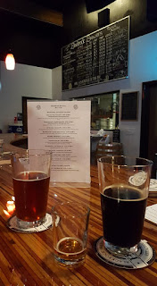
We saved the best for last. I treated Steve to a round of beers at the Black Rock Brewing company (BRB) off S. Pantano. Even after my third visit here, the place is not easy to find. In March 2019 the brewery will be open for two years. The place is never busy when I drop by, but it does have a steady stream of customers who sit at the counter. Sabrina was our server, a petite blonde pony-tailed young gal. Several new beers were on the menu.
I had a pint of the Vanilla Infused Porter, then tried the seasonal Punkin Spice Porter (sweet, nicely spiced, but a bit too carbonated), and tasted the Peach Ale and a few IPAs. Steve liked the IPAs. The Baja Sol IPA won the Gold Medal at the 2018 Baja Brew Fest and it is quite tasty. By the end of the visit he told me that the beers that he tried tonight were the best he's had in Tucson. Sounds like repeat visits to the BRB are in our future!
https://hikearizona.com/decoder.php?ZTN=454
https://www.alltrails.com/trail/us/arizona/sycamore-reservoir-trail
https://encyclopedia.densho.org/Hirabayashi_v._United_States/

https://hikearizona.com/decoder.php?ZTN=454
https://www.alltrails.com/trail/us/arizona/sycamore-reservoir-trail
https://encyclopedia.densho.org/Hirabayashi_v._United_States/
Lighting damages 75-100 palm trees in Agua Caliente Park, 092822
https://www.kold.com/2022/09/28/lightning-caused-fire-agua-caliente-park-under-control/
https://www.kold.com/2022/09/28/lightning-caused-fire-agua-caliente-park-under-control/
No comments:
Post a Comment