
Tinker Canyon is a narrow canyon on Fort Huachuca that borders Brown Canyon to the north. I had never been in this canyon and was delighted to see this hike offered as a hike by the hiking club's fast hiker, JimA.
But I slept horribly the night before, waking up at 1:30am and never getting back to sleep. By 4:30am I was getting tired again but never fell asleep. I knew I could not hike safely in a tired state and opted not to meet the group at the designated 7:30am meetup.

Instead, I followed the group an hour later and did my own hike, hoping I'd run into them along a ridgeline. I had followed the driving directions. A herd of proghorn antelope were in the middle of Garden Canyon Road on my way to the trailhead, which got the dogs barking. I stopped to photograph them. The herd ran off to the safety of the nearby field, looking back at me and wondering why the truck was barking at them.

The trailhead was the Tinker Pond Land Navigation course near the post aerostat. The post had conducted a control burn a few weeks ago and I could still smell the chemicals used to burn the grass. Even while on active duty and assigned to Fort Huachuca, I had never done land navigation training here; it was always on the northern site closer to Black Canyon.
I was hoping either Zeke or Minnie would be able to sniff out where the hiking group had gone, but to no avail. They seemed more interested in sniffing out the area. All the trails here were wide firebreaks and I took the main one going in a southwesterly direction uphill through a gentle slope. Burned hills were on either side of me. If it hadn't been for the smell, this would have been a nice hike. The hills around me had craggy tops.
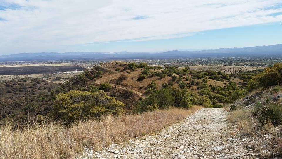
I wanted to find Tinker Pond. I'd heard of the pond but had never been to it. Where was it? Even as the road gained in elevation, I couldn't see any semblance of a pond. At 1.7 miles into the canyon I was now deep enough to be away from the burned area and hidden from view. I could have continued going higher and deeper into the canyon, but opted to cut south and take a ridgeline (the Sheelite Ridgeline, according to my GPS) that borders with Brown Canyon. From here one can see into Brown, see the Brown Canyon Ranch house and Sierra Vista. It gives a new perspective of Brown from this vantage point. It also reveals an old rusty barbed wire as post boundary; not a very secure border in these times. Part of the barbed wire fence was cut open and surely that was done by border crossers coming up from the Brown Ranch House. Who else would take a steep slope up into military property?

I spotted a water gathering tank below and went down from here to explore. This was "Site Boston." I also spotted a "Gobblers Guzzler," a small water fountain placed here by the Forest Service to provide water for the wild turkey that roam through. Although I had my own water for the dogs, I let them drink from this source. Zeke even placed his paws in the water. The burned spots still felt warm to the touch (but were not hot). Nearby was a rusty old car chassis laden with bullet holes.


I gave Sadie her ice cubes and sat in the shade of the cars. She likes munching on ice. Thirty minutes later the rest of the group came by. Rod, SteveS, SteveA, Mell, JimA, ColeM, Jody, Stephanie and Kent were in this group. I looked at Rod's GPS: I had turned south and back along the perimeter one firebreak too soon. Tinker Pond was just the next intersection higher in the canyon. ARG!
This would be a lovely hike once the green grass grows back and the smell dissipates. I want to do this hike again soon as it's remote and scenic.

http://www.mapmyhike.com/workout/2083654109
No comments:
Post a Comment